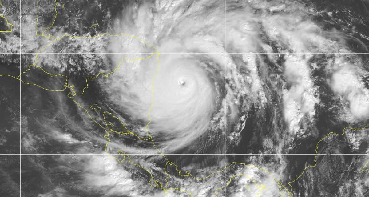
Hurricane Iota on November 16, 2020 at Category 5, the strongest hurricane of the 2020 season and latest category five hurricane to hit Nicaragua. Iota reach 160 MPH winds and a minimum central pressure of 917 mb (27 inches of mecury.)
NOAA GOES 16 Satellite Photo
Record Breaking Hurricane Season Most Active—Fifth Most Costly
A La Niña in the southeast Pacific Ocean drove the most active Atlantic Hurricane Season on record and the fifth costliest. The season totaled 31 tropical or subtropical cyclones of which 30 developed into named storms. It became only the second season (2005 was the first) on record to exhaust the list of names and delve into the Greek letter naming system. Of thirty named storms, 27 set new records for the earliest storm beginning with Cristobal on June 1. The 2020 hurricane season was the fifth consecutive above average season.
Thirteen storms developed into hurricanes and of those, six were major hurricanes of category 3 to 5. Hurricane Iota reached Category 5. 2020 also featured 10 storms with rapid intensification.
Following Cristobal, one storm after another set new records for earliest formation. Prior to Cristobal, Cindy was the earliest “C” named storm which formed on June 20, 2017. Cristobal set other records, including the first storm to retain tropical characteristics all the way to Wisconsin and across the Great Lakes to the Hudson Bay in Canada before it dissipated on June 13.
With the record breaking 2020 Atlantic Hurricane Season in the books, it is tempting to take a break and a big gulp of air. For now, the danger has passed. However, with the 2021 hurricane season only four months away, the now is the time to prepare. Organize supplies. Secure a source of backup power. Make a plan and be ready to put it into action.

Pre-Season Tropical Storms Set the Stage
The hurricane season officially starts on June 1 and ends on November 30, but tropical cyclones can form in any month. In 2020, Tropical Storm Arthur formed on May 16 with peak winds of 60 MPH as it passed east of North Carolina. Eleven days later, Tropical Storm Bertha developed near South Carolina and made landfall at Isle of Palms, SC causing local flash floods and spawning a small tornado that caused moderate damage. TS Cristobal formed just three days after Bertha dissipated.
Seven more tropical storms followed Cristobal until July 23 with the formation of Hanna out of Depression Eight. Hanna became the first hurricane of the season on July 25. Hurricane Hanna was the first storm of the season to highlight the realities of a disaster during the global Coronavirus Pandemic. The hurricane brought flooding, storm surge, torrential rain, tornadoes, and widespread power outages to South Texas. The hurricane was blamed for at least five deaths by drowning in flood waters or rip currents.
Tropical Storms Dolly and Edouard followed on June 22 and July 4 as Depression Five and Six. Neither storm posed a significant risk to land, although Bermuda posted gale warnings for Tropical Storm Edouard.
Fay followed on July 6 and formed off the Georgia coast. It made landfall near Atlantic City, New Jersey. Six people drowned in rip currents and storm surge caused by Tropical Storm Fay. Damage estimates to the East Coast exceeded 350 million dollars.
Tropical Depression Seven formed out of a tropical wave over the central tropical Atlantic. On July 22 the NHC designated the system Tropical Storm Gonzalo. Peak sustained winds reached 65 MPH. The system lost strength and eventually made landfall on the island of Trinidad as a weak tropical storm and degenerated into a low before it made landfall again in Venezuela.

Hurricane Hanna Hit Texas Twice
Tropical Depression Eight formed over the Gulf of Mexico on July 23. The next day, National Hurricane Center forecasters upgraded the storm to Tropical Storm Hanna as it moved almost straight west across the Gulf. On the twenty-fifth, Hanna had become a hurricane. It continued to intensify with peak winds of 90 MPH just before landfall on Padre Island, Texas. It then made a second landfall two hours later at Kenedy County at the same strength.

Tropical Storm Hanna bears down on Padre Island, Texas prior to becoming a hurricane. NOAA GOES 16 Satellite Image.
Hurricane Isaias Swept the East Coast
The rate at which storms formed over the Atlantic Basin during the 2020 Hurricane Season was impressive. On the same day that Hanna formed over the Gulf of Mexico, forecasters were also tracking a tropical wave coming off the coast of Africa with a high potential for development. It gradually organized over the next seven days into Tropical Storm Isaias. Isaias first made landfall on the Dominican Republic on July 31. Within hours after leaving the island nation, Isaias strengthened into a hurricane with 80 MPH sustained winds. The storm made a second landfall on North Andros in the Bahamas and weakened into a tropical storm.
As Hurricane Isaias turned north along Florida and then Georgia and forward motion increased, wind shear prevented development. Just before landfall on North Carolina, wind shear decreased as the Hurricane Isaias intensified to Category 2.
It weakened slowly as it crossed South Carolina into New England where it finally transitioned to an extra-tropical cyclone near the Canadian border. Isaias spawned a tornado outbreak with 109 warnings in 12 states, 39 of which touched down. Fifteen people were killed in the United States, three in the Dominican Republic and Puerto Rico. Initial damage estimates exceeded 4.5 billion dollars. Hurricane Isaias was the costliest hurricane to hit the Northeast since Hurricane Sandy.

Hurricane Hanna Over the Bahamas as it Turns North for the East Coast. NOAA GOES 16 Satallite Image
Kyle and Josephine
Tropical Depression Ten formed off Africa on July 29, but failed to organize and dissipated on August 2. Tropical Storm Kyle and Tropical Storm Josephine were the next two storms to shatter previous records for early formation.
Tropical Storm Josephine came out of Depression Eleven over the Central Tropical Atlantic. At first, wind shear and dry air prevented development for two days. On August 13, the NHC named it Tropical Depression Josephine. By the 16th, Josephine weakened to a depression and the cyclone dissipated later that day.
Warm water east of the Outer Banks allowed a system of low pressure to rapidly organize into Tropical Storm Kyle and move east northeast. Upper level winds forced the system into an elongated shape and it lost its circulation. Kyle was absorbed by European Extratropical Storm Ellen and helped bring hurricane-force wind to the Ireland and the United Kingdom.

Tropical Storm Kyle off the Outer Banks eventually merged with another system to bring hurricane force winds to Ireland and the United Kingdom. NOAA Satellite Image.
Major Hurricane Laura and Hurricane Marco
Two storms, Hurricane Marco and Hurricane Laura, formed on August 20 and appeared ready to converge on Louisiana. Initially, Marco appeared a more significant threat. However, Marco lost intensity while Hurricane Laura gained strength over the Leeward islands. Once Laura became a hurricane on August 25, it rapidly intensified to Category 4 within a day. The National Hurricane Center clocked sustained winds at 150 MPH, the strongest hurricane on record to landfall in Louisiana.
Marco became a hurricane on August 22, but strong wind shear caused the system to weaken. Marco made landfall near the Mississippi river as a tropical storm with 40 MPH winds on the twenty-fourth. Three days later, Laura made landfall near Cameron, Louisiana.
Major Hurricane Laura was blamed for at least 77 deaths including four in the Dominican Republic, 31 in Haiti, and 42 in the United States, making Laura the deadliest U.S. hurricane of 2020.
Marco and Laura were the second and third storms to make a Louisiana landfall in 2020. Laura caused nearly 20 billion dollars of damage.
Did you know that a whole house generator keeps the power on for days or even weeks after a hurricane? The generator runs on natural gas or propane. Finding gasoline isn’t a problem. Unlike a portable, a whole home generator powers heating and cooling in addition to the rest of the house.

Nana and Omar, Paulette and Rene
The end of August saw Tropical Depression Fifteen formed off the southeast coast of the United States. The depression struggled in a region of high wind shear, but eventually strengthened into Tropical Storm Omar on September 1. By September 5, it degenerated to a Low and dissipated.
While Omar struggled, another system in the Caribbean developed into Tropical Storm Nana on September 1 in a region of moderate wind shear. The shear later subsided and Nana intensified to a hurricane on September 3 before making landfall at Belize.
Hurricane Nana crossed Central America to the Pacific Ocean where its remnants formed into Tropical Storm Julio.
Hurricane Paulette formed on September 7 and meandered around the Atlantic until September 23. It made landfall on Bermuda on September 14 with 90 MPH winds. Peak strength came after it left the island when it reached 105 MPH. Paulette downed trees and wrecked power lines throughout Bermuda.
Paulette was blamed for one death in New Jersey when a man drowned while swimming in heavy surf conditions.
Tropical Storm Rene formed from a tropical wave moving off Africa east of the Cabo Verde Islands on September 7. The system organized into a tropical depression that day and made landfall as Tropical Storm Rene twelve hours later on September 8. The storm lost strength and continued as a depression until September 14.
Hurricane Paulette is followed by Tropical Storm Rene over the Tropical Atlantic Ocean. Paulette impacted Bermuda, Rene dissipated after making landfall on the Cabo Verde Islands. NOAA Satellite Image.
Hurricane Sally
An area of convection formed over The Bahamas on September 10 and organized into Depression Nineteen before it crossed the southern tip of Florida on September 12. In the Gulf of Mexico, it strengthened and organized into Tropical Storm Sally shortly after leaving Florida. A period of rapid intensification organized the storm into a category 2 hurricane with 90 MPH winds.
Increasing shear weakened the system to a tropical storm as it headed north. Near the coast, Sally again intensified and developed a well-defined eye as it once again gained category 2 strength. Hurricane Sally made land fall at Gulf Shores, Alabama with 105 MPH wind. Eastern Alabama and western Florida were hardest hit with wind damage, storm surge, and flooding from over 24 inches of rain. Eight people were killed. Damage estimates reached 6.25 Billion Dollars.
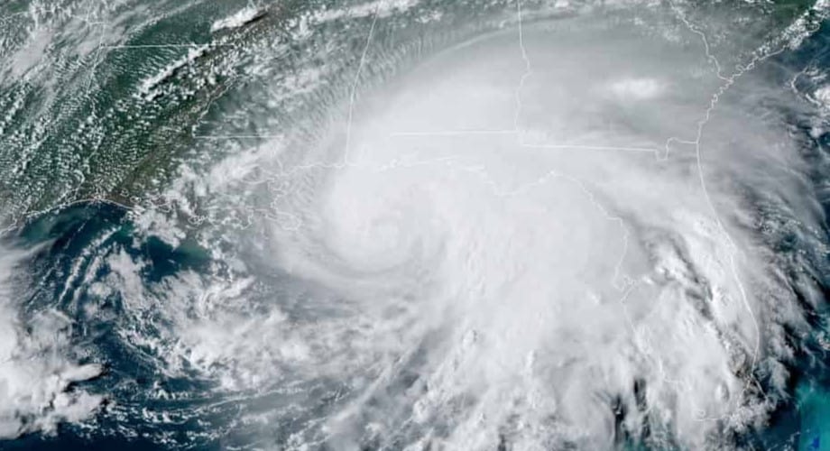
Hurricane Sally as it Nears Gulf Shores, Alabama at Category 2 with 105 MPH Sustained Wind. Sally Killed 8 People.
NOAA Satellite Image.
Six Active Storms
Most seasons may generate one or two and occasionally three cyclones over the Atlantic Basin. The 2020 Hurricane Season often had multiple systems present at one time.
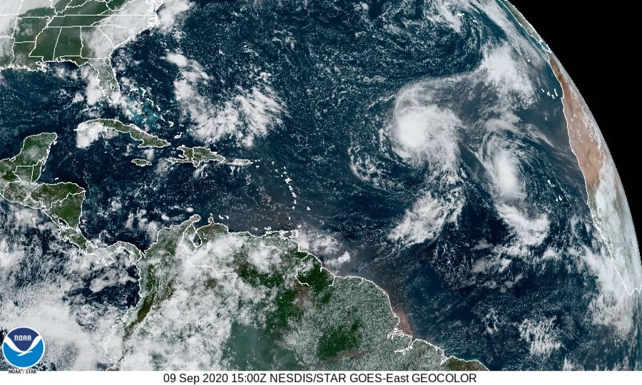
While the depression that would become Hurricane Sally crossed Florida, six tropical cyclones and systems with tropical characteristics were present in the Atlantic Basin. Tropical Storm Sally just east of Florida. Tropical Storm Paulette headed for Bermuda. Rene, once a tropical storm, had lost strength but was still an active depression. Tropical Depression Twenty (Later Hurricane Teddy) West of Cape Verde. A tropical wave near the Cape Verde Islands would later become Tropical Storm Vicky. Another system south of Louisiana would later become Tropical Storm Beta.
The season peak occurs on September 10. In 2020, the peak stretched out over two weeks. The NHC names storms in the order of that depressions form. This can make it appear that names are sometimes assigned out of alphabetical order. For instance, Tropical Storm Vicky was named before Hurricane Teddy.

Six systems over the Gulf of Mexico and Tropical Atlantic. From left to right. The yellow area becomes Tropical Storm Beta on September 17. The orange zone became Hurricane Sally. Next are Tropical Storms Paulette and Rene. Paulette intensified to a hurricane. The red zone beneath Paulette and Rene will become Hurricane Teddy. The orange zone above develops into Wilfred on the 18th.
NHC Center 2-Day Outlook for September 11, 2020
Hurricane Teddy
Depression Twenty strengthened into Tropical Storm Teddy on September 14. Teddy was the next storm to undergo rapid intensification and became a category 2 hurricane on the same day. It lost some strength as it passed through an area of wind shear but remained a category 1 hurricane. The shear subsided and Teddy rapidly intensified to a Category 4 hurricane as it crossed the Atlantic on a northwest track.
On the twentieth, it weakened to category 2 after at least two eyewall changes. Further weakening occurred as it began to merge with another system in the North Atlantic. By September 23, Hurricane Teddy had become an extra-tropical cyclone with category 1 winds, but the wind field had expanded with hurricane force winds 150 miles from the storm center and tropical storm force winds extending 550 miles from the center—up to 1100 miles from one side of the storm to the other.
The cyclone made landfall in Novia Scotia on September 22 with sustained winds of 65 MPH. Teddy caused high surf conditions and rip currents from the Caribbean to Bermuda and all along the United States East Coast. Three people drowned in the rip currents.

This NHA Outlook Graphic on September 18 shows how quickly the season moved from storm to storm. On the far left, Depression Twenty-Two surprised forecasters as the area with a low chance of development was found to have closed circulation. This became Tropical Storm Beta within hours. Barely visible on the far upper right is Tropical Storm Alpha which made landfall in Lisbon, Portugal, a very unusual location for cyclones to form. The yellow area to the right of TS Wilfred dissipated without forming a cyclone. The Yellow zone to the north of Wilfred is the remnants of Hurricane Paulette and would reform into a tropical storm on September 21st. NHC 2-Day graphical outlook for September 18.
Season Peak Exhausts Storm Name List
The season peak around September 10 continued with more storms. Tropical Storm Vicky formed out of a tropical wave near the Cape Verde islands on September 14. Vicky took an east by northeast track and lost strength by September 17. Vicky caused one death by drowning in the floods on the Cabo Verde Islands.
On September 10, forecasters expected no development from another low-pressure system in the southern Gulf of Mexico due to interaction with Hurricane Sally in the Gulf at the same time. However, as Sally moved north and the low moved south, a hurricane hunter aircraft verified closed circulation and the NHC designated the system Depression Twenty-Two on September 17. The next day, Twenty-Two organized into Tropical Storm Beta. It then meandered north before turning west. Beta made landfall on September 22 on the Matagorda Peninsula, Texas. Beta causes extensive flooding in Houston area. Beta was blamed for one drowning death.
Wilfred was the last name on the list assigned to the 2020 Season. Forecasters watched another system ready to move off the coast of Africa on September 13. The system had gale-force winds and a low-level center on the 17th and was designated Tropical Storm Teddy. It remained weak due to wind shear and wind interaction from Hurricane Teddy. The low latitude also prevented substantial development. By the 21th, Wilfred degenerated to a trough.
Sub-tropical storm Alpha formed a few hundred miles north of the Azores, an unusual location for tropical cyclones to form. The National Hurricane Center and Meteo France tracked the system as it moved southeast. It gradually organized despite conditions normally not conducive to development. It became better defined on the 18th just before landfall near Lisbon, Portugal. A woman died when her roof collapsed. Alpha caused extensive flooding and wind damage and spawned two tornadoes. A train derailed in Spain and lightning caused a forest fire.
A week after Alpha hit Portugal, Tropical Storm Gamma formed on October 2 in the Caribbean Sea following another system on October 1 that would eventually become Hurricane Delta. Gamma would hit the Yucatán Peninsula on October 3 after thousands of evacuations. The tropical storm produced heavy rain, flash flooding, and mudslides in addition to seven fatalities.

Major Hurricane Delta weakened over the Yukatan Peninsula and tracked north to Louisiana as a Category 3 Hurricane with 100 MPH Winds.
NOAA GOES Satellite Image.
Major Hurricane Delta
NHC forecasters began monitoring a tropical wave east of the Lesser Antilles on October 1 and labeled it potential tropical cyclone twenty-six. By the fifth, it had organized into Depression Twenty-Six. South of Jamaica on the same day, it began to rapidly intensify and became Tropical Storm Delta. Twelve hours later it was a hurricane. The next day, a Hurricane Hunter aircraft found it had grown to a Category 4 hurricane with sustained winds of 130 MPH.
The storm had intensified at an incredible rate over 27 hours from tropical depression to a major hurricane.
After weakening slightly, Major Hurricane Delta made landfall on the Yucatán Peninsula on the seventh and emerged over the Gulf of Mexico as a category 1 hurricane. Another period of intensification followed to become a major hurricane, but weakened slightly before making landfall at Creole, Louisiana with 100 MPH as the fourth named storm of 2020 to hit Louisiana.
Hurricane Epsilon

Epsilon formed out of a non-tropical low south of Bermuda that eventually became Tropical Depression Twenty-Seven and later Tropical Storm Epsilon. Hurricane Epsilon was another storm that underwent rapid intensification. It turned north toward Bermuda and strengthened to a category 3 hurricane, the fourth of the season.
Epsilon surprised forecasters. It intensified over cool sea temperatures and in an area of moderate wind shear. It was also the farthest east a cyclone underwent rapid intensification so late in the season.
The cyclone weakened slowly as it moved north and passed 190 miles from Bermuda. It produced waves up to 100 feet on the coast of Ireland and large swells across the northern Caribbean. Early tropical storm warnings issued for Bermuda were canceled.
Three Hurricanes Punctuate the 2020 Hurricane Season Finale
Depression Twenty-Eight strengthened into Tropical Storm Zeta on October 25. Fighting wind shear, Zeta strengthened into a hurricane by the next day when it crossed the Yucatán Peninsula and weakened to a tropical storm. Zeta rapidly intensified on the 27th and reached peak winds of 110 MPH as it made landfall at Cocodrie, Louisiana.
Hurricane Zeta was the fifth and final cyclone to hit Louisiana in 2020. It retained tropical storm strength all the way to Virginia before transitioning to a post-tropical storm. Seven people lost their lives and power outages affected 2.6 million utility customers. it disrupted early voting in several states. As a final parting shot, it left snow on New England as it moved over the Atlantic.
Depression Twenty-Nine formed over the eastern Caribbean Sea on October 31. Rapid intensification made it Tropical Storm Eta on November 1 and Major Hurricane Eta on November 2, reaching category 4 strength the same day with peak intensity of 150 MPH. It would make landfall on Nicaragua on November 3 and weaken again to a tropical storm. A shift in track took it back to the Caribbean Sea, then a northerly track over Cuba on November 8. It strengthened to a hurricane before another landfall at Cedar Key, Florida on November 12.
Eta caused more than 200 fatalities in Central America, the deadliest 2020 Atlantic hurricane. Two weeks later Major Hurricane Iota would impact relief efforts and take more lives.
Tropical Storm Theta formed off the coast of Africa on November 10 and dissipated on November 15 without threatening land. It reached a peak strength of 70 MPH sustained winds and a central pressure of 989mb.
Depression Thirty-One formed in the central Caribbean on November 13 and strengthened to Tropical Storm Iota the same day. Iota rapidly intensified on November 14 and reached hurricane strength the next morning. It was a category 3 on the 16th and Major Hurricane Iota at Category 5 with 160 MPH winds on November 15.
Just before it reached the coast of Nicaragua, it lost enough strength to hit at category 4 just a few miles south of the Hurricane Eta Landfall.
Iota caused another 61 deaths and devastated the local infrastructure, still under repair from Hurricane Eta just two weeks earlier.
Iota was the last and strongest tropical cyclone of the 2020 Hurricane Season.

Record Breaking Hurricane Season
The 2020 Hurricane Season produced thirty-one tropical depressions, 13 hurricanes, 6 major hurricanes, and 18 tropical storms. It caused over 51 billion dollars in damage and took more than 430 lives in the United States, Mexico, Central America, and the Caribbean. It was the most active on record and the fifth consecutive above average activity season beginning in 2016.
All the storms beginning with Cristobal were the earliest named or numbered storm on record. Cristobal was the earliest “C”-Named or third storm of the season. The season produced two major hurricanes in November, another first.
The global pandemic presented new challenges with a shortage of shelter space. Some states set up COVID-19 testing centers to facilitate shelter safety.
2021 Hurricane Season Discussion
Early forecasts by Tropical Storm Risk and Colorado State University put the 2021 Hurricane Season number of named storms at 15-16, hurricanes at 7-8, and major hurricanes at 4. The 2020 season produced double the named storms, nearly the double the number of hurricanes, and fifty percent more major hurricanes than originally predicted. Throughout the season, all the major tropical weather predictions increased with each new forecast until the NOAA issued its final prediction on August 6. CSU, TSR, and NOAA all fell short by at least seven named storms.
Forecasters make long-range predictions based on computer models using the latest science. Weather models use information provided by other models to produce a percentage chance for each potential outcome. The first 2021 discussion on December 10 issued by Colorado State University Tropical Meteorology Project is an example where different models produce an estimated percent chance of a particular outcome using AMO and the Chance of El Niño to produce an estimated ACE and the percent chance of the ACE under those conditions. On other worlds, if the AMO is very strong, and an El Niño does not form, there is a 25 percent chance for an ACE of 170.
We can then use historical data to estimate the number of storms based on various ACE scenarios.
|
AMO* |
Chance of El Niño |
ACE** |
Percent Chance |
|
Very strong |
No El Niño |
170 |
25 |
|
Above Average |
No El Niño |
130 |
35 |
|
Above Average |
El Niño |
80 |
20 |
|
Below Average |
No El Niño |
80 |
10 |
|
Below Average |
El Niño |
50 |
10 |
*Atlantic Multi-Decadal Oscillation: A mode of natural variability that occurs in the North Atlantic Ocean and evidencing itself in fluctuations in sea surface temperature and sea level pressure fields. The AMO is likely related to fluctuations in the strength of the oceanic thermohaline circulation. Although several definitions of the AMO are currently used in the literature, we define the AMO based on North Atlantic sea surface temperatures from 50-60°N, 50-10°W and sea level pressure from 0-50°N, 70-10°W ~CSU Tropical Meteorology Project
**Accumulated Cyclone Energy: A measure of a named storm’s potential for wind and storm surge destruction defined as the sum of the square of a named storm’s maximum wind speed (in 104 knots2) for each 6-hour period of its existence. The 1981-20 10 average value of this parameter is 106 for the Atlantic basin. ~CSU Tropical Meteorology Project
Two big factors are the state of the El Niño Southern Oscillation (ENSO) and the Atlantic Multi-Decadal Oscillation. Five above average seasons leads to a high confidence that the AMO will remain in a positive phase conducive to tropical cyclone formation. The current phase of ENSO is a La Nina’, but that could change. At this time of year, various models rarely agree on the forecasted state of ENSO. An El Niño decreases the number of hurricanes in the Atlantic while a La Nina increases the number of hurricanes. A neutral ENSO (neither a La Nina or El Niño) may indicate average Atlantic Hurricane Season activity.
As seen in the table above, there is an 80 percent chance for an Above Average 2021 Atlantic Hurricane Season.
Accumulated Cyclone Energy shows how many storms may occur.
2021 Hurricane Season Forecast
|
ACE |
Named Storms |
Hurricanes |
Major Hurricanes |
|
170 |
14-17 |
9-11 |
4-5 |
|
130 |
12-15 |
6-8 |
2-3 |
|
80 |
8-11 |
3-5 |
1-2 |
|
50 |
5-7 |
2-3 |
0-1 |
In 2021, the Global Pandemic will likely continue to affect how local, state, and federal agencies respond to disasters and provide emergency shelter.


