Hurricane Isaias Over the Turks and Caicos Tracking Toward the Bahamas and Florida
Hurricane Isaias
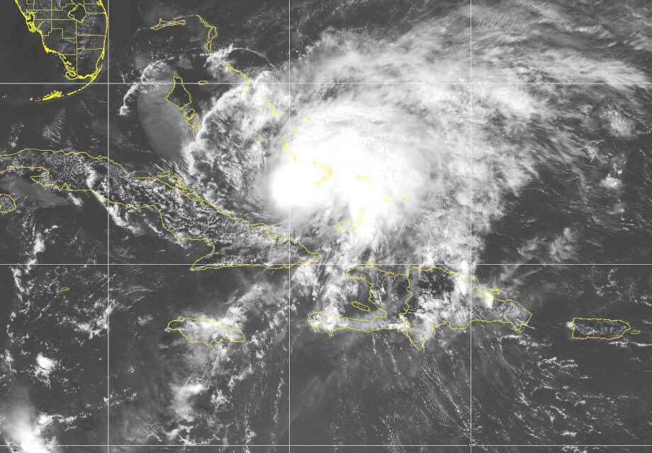
The tropical wave off the coast of Africa was expected to form a tropical cyclone, but it took longer than expected. The fast-moving system finally got organized after reaching the Lessor Antilles. As Depression 9 moved west it toward Dominica, it finally pulled itself together into a tropical storm. Now Hurricane Isaias will cross the Bahamas as a category 1 hurricane and begin to affect Florida’s East Coast Tonight through Saturday, then Georgia with a good chance for landfall in North Carolina on Monday on Oak Island near Southport. Isaias will leave land behind near Norfolk, Virginia and head toward Massachusetts
Storm tracking beyond three days become less reliable. A possible second landfall around Buzzard’s Bay, Massachusetts is five days away. Isaias’ track could change before, especially while it is over North Carolina and Virginia. Regardless, the entire East Coast should Prepare Homes and Property for Hurricane Isaias. Florida residents should rush to prepare for strong winds and up to four inches of heavy rain. Low-lying areas along the coast could have storm surge, especially northeastern Florida.
Water up to 90 degrees lies in Isaias’ path and helps the storm maintain strength or grow stronger. However, wind shear will limit how much it can develop. The Hurricane has a small chance of reaching category 2 strength with 95 to 110 MPH winds.

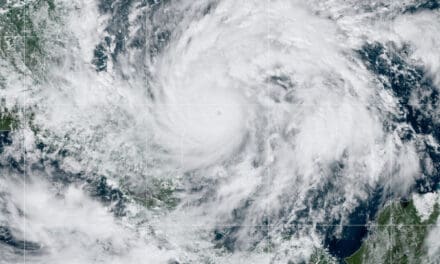
Forecast Track on July 31, 2020 with Watches and Warnings
Key Messages from National Hurricane Center
11:00 AM EDT on July 31, 2020
Heavy Rain: Expect Isaias to produce heavy rains of up to 10 inches over the Bahamas with most areas receiving four to six inches. Life-threatening flash floods and mudslides are possible across the Dominican Republic, Northern Haiti, Turks and Caicos, and the Bahamas.
Tropical Storm conditions will develop heavy rain in South and East Central Florida late tonight and the eastern Carolina’s on Monday and Tuesday. Flash flooding and urban flooding are possible, and some river flooding as well. Two to four inches for most of the Florida East Coast with up to six inches possible in the West Palm Beach area and further north. Up to six inches is also expected for portions of North Carolina where the hurricane makes landfall.
Hurricane Conditions and Dangerous Storm Surge are expected in the Bahamas today and Hurricane Warnings are in effect. Rush to finish preparations.
Tropical Storm Warnings are in effect for South and East Central Florida. Hurricane and Storm Surge Warnings may be issued later today for South and East Central Florida. Storm Surge levels depend on the timing of the storm and are greatest during high tide.
Hazards: Strong Wind, Heavy Rain, and Storm Surge beginning late this weekend for the Northeastern Florida Coast spreading north along the East Coast through early next week. Impacts are in the current forecast from Florida through Massachusetts. Isaias will cause scattered power outages along the coast of Florida and widespread power outages in the Carolinas and Virginia as it makes landfall. More outages are possible in Massachusetts.

Infrared Satellite Image of Hurricane Isaias on July 30, 2020
Preparing for Hurricane Isaias
Hurricane Isaias is a dangerous storm that could reach category two before it makes landfall in North Carolina. Everyone along the East Coast should prepare for this storm even if their area only expects tropical storm conditions.
- Fill Vehicle Gas Tanks now. Check stores of gasoline for portable generators. Start and run your portable generator for fifteen minutes so it’s ready when you need it. Standby Generator owners should check maintenance supplies like spark plugs, filters, and oil.
- Download and Install the FEMA Mobile App for all emergency warnings. Set alerts for your local area. Text PREPARE to 4FEMA to receive preparedness tips from the agency. Follow local government on social media for important updates and instructions.
- Prepare your home by storing anything outdoors that is not permanently fastened down. BBQ grills, patio furniture. Play equipment and toys. Cover windows with plywood and fasten with lag bolts or lag screws. Reinforce Garage Doors and wide Patio Doors if they are designed for a hurricane.
- Evacuate if ordered. Let family members know where you are going. Don’t forget your pets and don’t leave them behind. Any evacuation plan should include your pets.
- Move your Hurricane Preparedness Kit and Supplies to your designated safe room, preferably an interior room without windows. Make everyone comfortable including pets. If you evacuate, take your kit and supplies with you.
Hurricane Isaias will be the second hurricane to make landfall in the United States this year. Other storms are on the horizon. Everyone living along the East or Gulf Coast should prepare for more hurricanes. The season peak is a few weeks away and more storms will head for the United States Coast.


