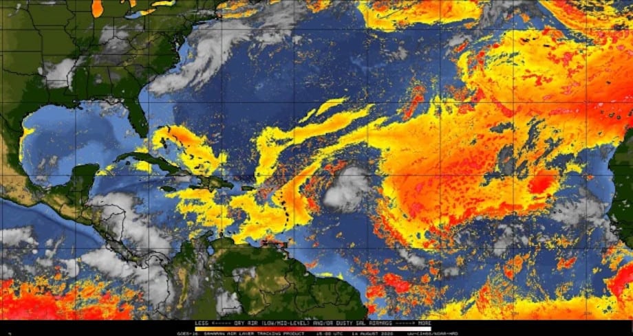
A GOES East Satellite Image shows the dry, dusty air surrounding Tropical Storm Josephine as orange, yellow, and red hues.
Image via NOAA GOES East August 14, 2020
Josephine Breaks Previous Record as Earliest `J’ Storm
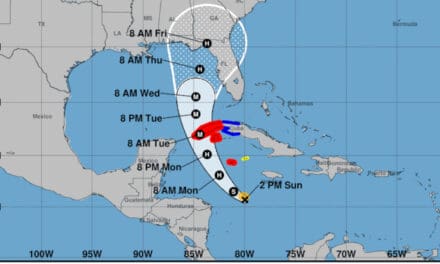
The record for the earliest J-named storm goes back to August 22, 2005, when Jose broke the previous record. Tropical Storm Josephine broke the record by nine days when it formed Thursday morning on August 13, 2020, after struggling to organize over east tropical Atlantic. Friday morning the cyclone had moved to within 600 miles of the Leeward Islands as it moved to the northwest at 16 MPH with 40 MPH sustained winds. Forecasts for the weekend include gusty winds and downpours as Josephine sweeps by. The current storm track indicates no landfall anywhere on the Leeward Islands or in the Caribbean.
Josephine has some opportunity to strengthen over warm ocean water through Friday. Increasing wind shear and dry air will limit further development and the storm should begin to gradually weaken. The storm will pass north of the islands on a northwest course before it begins a turn to the north. By Monday, forecasters expect Josephine to weaken to a depression as it takes aim on Bermuda and possibly dissipate.
Standby Generators for Power Outages
Leeward Islands include Antigua, Guadeloupe, Dominica, Martinique, Saint Lucia, Barbados, The Virgin Islands, Saint Kitts, and Nevis.
A low-pressure area off the coast of North Carolina has some opportunity to develop into a depression or tropical storm. If the system remains south of an approaching area of strong vertical shear through Saturday, it could form a sub-tropical system before it moves over colder water late on Sunday.
Spinning up to fly Tropical Storm #Josephine. ✈️⛈🌪🌊
— Hurricane Hunters (@53rdWRS) August 14, 2020
(U.S. Air Force photo by Maj. Jeremy DeHart)#ReserveReady #ReserveResilient #WeatherReady #WC130J #SuperHercules @NOAA_HurrHunter @NHC_Atlantic pic.twitter.com/ERNObf7GP2
Season Peaks from Late August Through October
The Atlantic Hurricane Season starts June 1 and ends on November 30. The season begins to peak in late August and early September before it gradually declines through the end of October. An average year includes 12 named storms by the end of November. Forecasters expect a very active to extremely active season. Still four weeks away from the peak, the season has already produced 10 named storms. Expect more activity as the end of August and beginning of September approaches.
September 10th is the official season peak.
In the weeks ahead, projections show a very active Atlantic Ocean. Very warm water provides the energy for tropical systems to form. A decrease in vertical wind shear—different wind speeds at different altitudes—keeps low pressure areas together and allows them to organize into cyclones. The dry, dusty air from the Sahara Desert should dissipate as low pressure moves into the development region. All these factors combined with an active African Monsoon provide an environment ripe for Tropical Cyclone Development.
In Stock Generators Ship in 1-2 Days
The first three months of the six-month hurricane season have already produced almost half the average number of storms with the season’s peak still a month away.
invest #96L spinning east of VA Beach this morning. pic.twitter.com/HpGxzX39lj
— Jim Cantore (@JimCantore) August 14, 2020
Dangerous Record Temperatures Plague the West
Meanwhile, a dangerously hot heat wave will envelop the western United Stages with temperatures up to 30 degrees above normal. In Phoenix AZ, 2020 will go down as the hottest summer on record with the most days over 110 degrees. The average daily high temperature so far is 108 degrees.
Excessive heat watches in effect for Washington and Utah. Excessive Heat warnings in effect for for Arizona, California, Nevada, and Oregon. The region affected by heat warnings and watches expects triple digit temperatures. Death Valley may remain above 100 degrees for over 72 hours.
2017 Had a Heat Wave Similar to 2020
Intense heat can affect commercial air travel. Some airlines may impose baggage and weight restrictions in cities with excessive heat warnings. Travelers affected by the heat warning should expect delays.
Hot air and lack of rain may raise fire danger to explosive levels.
The heat wave should last into the middle of next week.
A dangerous, long-lasting heat wave is about to unfold over the western United States with temperatures expected to soar as much as 30 degrees F above normal from Arizona through Washington: https://t.co/WrWzpVBCiL pic.twitter.com/nEG06BHozC
— AccuWeather (@breakingweather) August 14, 2020


