
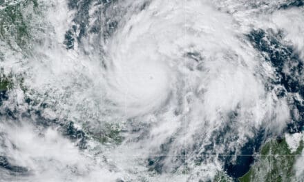
Tropical Storm Gonzalo 1200 miles east of the Windward Islands on July 23, 2020.
NOAA GOES East Satellite Image
Hurricane Watch in Effect—Warnings Expected
Tropical Depression 7 organized and strengthened into Tropical Storm Gonzalo yesterday morning (July 22) 1200 miles east of the Southern Windward Islands. The National Hurricane Center expects Gonzalo to further strengthen into the first hurricane of the 2020 Atlantic Hurricane Season and issued the first hurricane watches for St. Vincent and Barbados. More warnings and watches are likely. Gonzalo will reach the windward islands on Saturday, July 25. After passing over the islands, forecasters expect some gradual weakening while the storm encounters moderate wind shear and dry air.
Hurricane Preparedness Planning and Preparation
By Monday the 27th, Gonzalo will arrive in middle Caribbean Sea as a Tropical Storm with 45 MPH sustained winds. If the storm’s path takes it northwest into the Gulf and wind shear decreases, Gonzalo could strengthen into a hurricane. Too much uncertainly remains on the final path and where any impacts on the U.S. Gulf Coast might take place.
Gonzalo is the seventh named storm of the Atlantic Hurricane Season and shatters previous records for the earliest named “G” storm in history. The 2020 Hurricane Season continues to break records set in 2005.

Depression 8 Heads for Texas—May Strengthen to Tropical Storm Hanna
Tropical Storm Watches were issued for most of the Texas Gulf Coast as Tropical Depression Eight continued to strengthen. The depression will probably strengthen to a tropical storm sometime Friday morning (July 24) and reach the Texas Gulf Coast on Saturday July 24th. The NHC will name the storm “Hanna”, the eighth storm of the hurricane season and the earliest “H” named storm on record. Hanna will continue to set new records. Hurricane Harvey in 2005 was previously the earliest “H” named storm.
Impacts include flash floods, inland flooding, power outages, and wind damage.
Additional development beyond a tropical storm is not likely due mainly to lack of time. The system will reach land and begin to weaken. As a Tropical Storm, Hanna will bring 50 MPH winds and torrential rainfall. Forecasters expect Corpus Christi to receive up to eight inches of rain with locally heavier amounts up to 12 inches, according to Accuweather. Houston up to four inches, and similar amounts in Austin and San Antonio. Expect lessor impacts of 1-2 inches inland and along the Gulf Coast east to the Florida Panhandle.
Governor Abbot warned residents to prepare for flash floods and inland flooding.

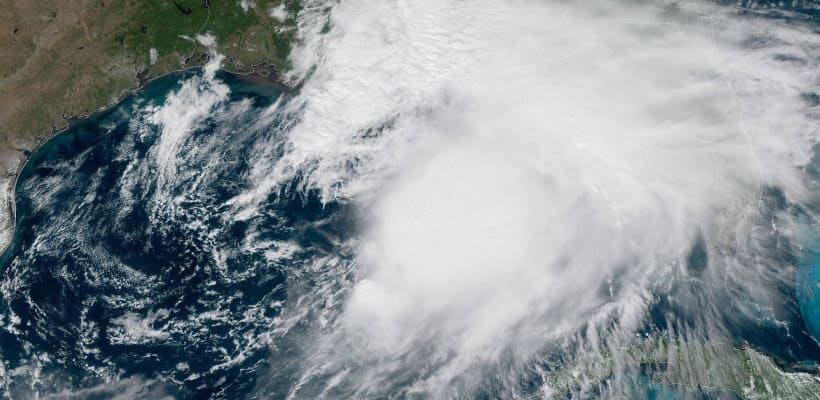
Major Hurricane Douglas Takes Aim on Hawaii
The First Hurricane of the Eastern Pacific Ocean intensified over a few hours to category 2. By Thursday morning, the rapid intensification turned Douglas into a power category 3 Major Hurricane with a well-defined eye as seen in the satellite image. Douglas is about 1300 miles east-southeast of Hawaii and moves north-northwest at about 20 MPH.
Automatic Standby Generators for Power Outages
Warm water and low wind shear will allow the storm to maintain major hurricane strength with 120 MPH winds through Friday morning. Gradual weakening is expected thereafter. Douglas will reach Hawaii late on Sunday or early Monday (July 27) as a Category 1 Hurricane. Actual impacts on Hawaii are too early to forecast. Residents should monitor the storm which could bring flash floods, damaging winds, and power outages.

2020 Atlantic Hurricane Season Forecast Summary
As in all hurricane seasons, coastal residents are reminded that it only takes one hurricane making landfall to make it an active season for them. They should prepare the same for every season, regardless of how much activity is predicted.
The Colorado State University Tropical Meteorology Project issues projections and forecasts beginning in December of every year. Other forecasters and agencies often give similar forecasts. Long-range forecasts always have a built-in margin of error. Exact forecasts weeks and months in advance are not possible with today’s technology.
In their July 7 update, the CSU Tropical Meteorology Project maintained their above-average hurricane forecast for the 2020 Atlantic Hurricane Season. The forecast includes:
- 20 Named Storms
- 9 Hurricanes
- 4 Major Hurricanes
Accumulated Cyclone Energy of 160 with a total of 85 Named Storm Days.


