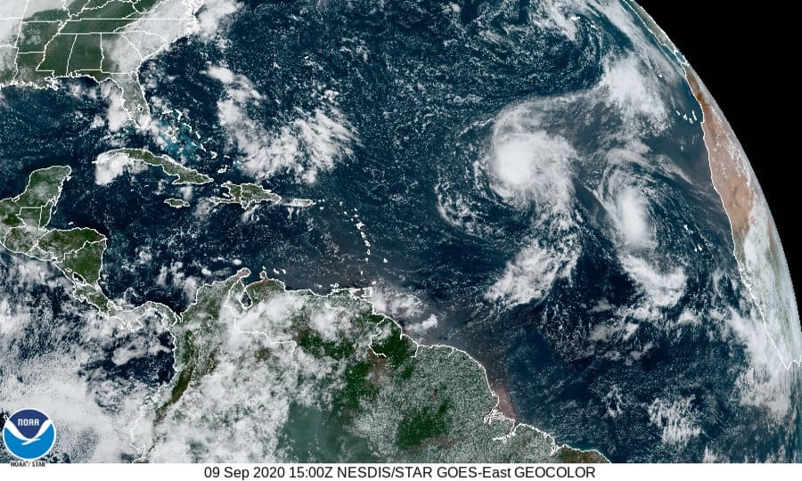
Two tropical storms seen over the eastern tropical Atlantic Ocean. Paulette is a much wider system but has little chance of intensifying for the next few days. Smaller Rene is further east but should become a hurricane by Thursday as it moves northwest. GOES East NOAA Satellite Image
Active Hurricane Season Reaches Peak with Two Storms in the Atlantic and Potentially Two More
As the Atlantic Hurricane Season reaches its peak, Tropical Storm Paulette formed over the weekend and Tropical Storm Rene followed on its heels within hours. Paulette is located over the central tropical Atlantic and poses no immediate threat to land. Forecasts indicated a slow development period until the system reached an area more conducive to development.
Tropical Depression 17 formed Sunday night and intensified to a tropical storm by Monday morning. The size of the storm may allow it to survive an area of strong wind shear. Most models currently point to Paulette making its way to the north of the Caribbean until it turns toward Bermuda and possibly pass between the islands and the U.S. East Coast. Bermuda residents should monitor the storm and prepare for impacts.
The tropical storm is currently moving at 8 MPH in a generally northwest direction with sustained winds of 65 MPH.
As of September 8, Paulette should remain a tropical storm, but that could change as it moves west and north. Through the weekend, Tropical Storm Paulette will not threaten land. The storm has a long way to go before it reaches Bermuda or the US East Coast.
Tropical Storm Rene
Tropical Depression 18 formed early on Monday hours after emerging off the African Continent. The Cabo Verde Islands had heavy rain and gusts to 50 MPH. Rene has since moved west at 16 MPH and 40 MPH sustained winds. Forecasters expect intensification to a hurricane on Thursday with sustained winds of 90 MPH—a strong category 1 hurricane. Rene will begin turn to the north-northwest on Thursday, pick up speed on Friday, and turn Northeast on Saturday.
Rene poses no immediate threat to land. Compared to Paulette, it is a relatively small storm that will grow larger as it moves through an area of low wind shear and warm ocean waters.
Tropical Storm Rene broke the record for the earliest 18th named storm by 11 days. Hurricane Rita in 2005 held the previous record when it formed as a tropical storm on September 18, 2020. Rene has another system following on its heels and about to come off the Coast near the Cabo Verde Islands.

Tropcal Storm Rene east of the Cabo Verde Islands in the eastern tropcial Atlantic Ocean will strengthen to a hurricane as it moves north. NOAA GOES East Image.
Two More Tropical Systems to Watch
An area forecasters call Invest 94L located 300 miles southwest of Bermuda will move northwest toward South Carolina. Warm, moist air and decreasing wind shear will allow some development before the system reaches land and it could become a tropical depression before the end of the week. There is potential for additional strengthening if it organizes soon enough and the wind shear continues to subside. Residents in South Carolina should monitor the system and be ready to act regardless of potential development as it brings drenching rains, flash floods, and strong thunderstorms with gusty winds.
Another system laden with tropical moisture will move off the coast of Africa by Thursday and lead to drenching showers and thunderstorms with strong winds. The National Hurricane Center gives this system an 80 percent chance of development in the next five days. The Cabo Verde Islands should prepare for another storm.
Everyone along the Atlantic Coasts from Africa to Central America, the Caribbean and Gulf Coast, and East Coast should remain alert and monitor the hyperactive Atlantic Hurricane Season as it progresses through the peak for the next 5 to 10 days.
NHC is monitoring 2 disturbances this Tuesday evening. One system could become a tropical depression over the next few days while it slowly approaches the Carolinas. The wave over Africa is likely to become a depression late this week or weekend. More: https://t.co/tW4KeFW0gB pic.twitter.com/QLeMosO84r
— National Hurricane Center (@NHC_Atlantic) September 8, 2020

The New Generac 24kW Generator for Larger Homes and Small Businesses Fits Small Lots and Pays for itself in energy savings with the PWRview ATS and PWRview Smartphone App for realtime energy use monitoring.

Tropical Storm Paulette as it moves northwest across the central Atlantic Ocean. NOAA GOES Image


