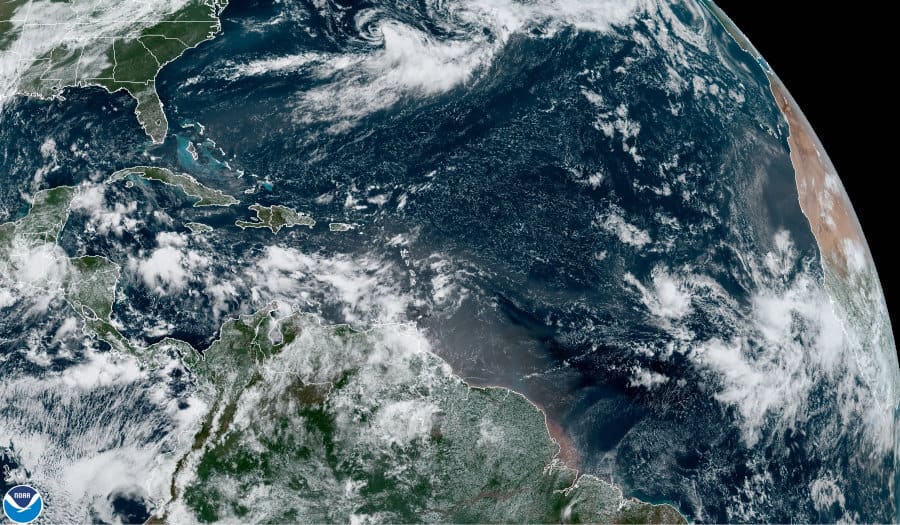
Depression Omar (Near Top) on September 3, 2020 after it weakened from a Tropical Storm. NOAA GOES 16 Satellite Image.
Fifteenth Named Storm of 2020 Hurricane Season is Earliest in History
Depression 15 strengthened to a Tropical Storm on Tuesday to become the fifteenth named storm of the record-setting 2020 Atlantic Hurricane Season. Omar is the earliest “O” storm on record, beating out Hurricane Ophelia. Ophelia was named on September 7, 2005. The 2020 hurricane season has the potential to top the 31 tropical cyclones or subtropical cyclones from the 2005 season. A new record is unlikely but not impossible.
September 2 to September 15 is the peak of the Atlantic Hurricane Season.
Depression 15 formed off the southern East Coast and traveled northeast. After strengthening on Tuesday to tropical storm, it weakened on Wednesday and is expected to degenerate to tropical low by Thursday. Omar had 40 MPH sustained winds for just 24 hours, just barely strong enough to qualify as a tropical storm.
The Tropical Atlantic remains active, on par for the peak of the hurricane season, where we continue to track Tropical Storm Nana, Tropical Depression Omar and several disturbances moving across the eastern Atlantic that have the potential of developing over the week. #LAwx #TXwx pic.twitter.com/3sXuQwzUjM
— NWS Lake Charles (@NWSLakeCharles) September 3, 2020

Hurricane Nana a few hours before it made landfall in Belize, Central America. GOES16 Image via NOAA
Hurricane Nana Approaches Belize
In the western Gulf of Honduras in the Caribbean Sea, Hurricane Nana is closing in on Belize. Hurricane warnings are in effect south and central Belize, tropical storm warnings for the northern coast. Adjacent coasts are under a tropical storm warning. Tropical force winds have begun in Belize.
Nana has maximum sustained winds of 75 MPH and hurricane conditions are expected in the hurricane warning area overnight through Thursday. Dangerous storm surge may affect the coast. Tropical storm warnings are in effect for Guatemala, the Yucatan Peninsula, and the Bay Islands. Heavy rainfall up to 12 inches will result in flash flooding through Belize, Guatemala, and the Yucatan Peninsula.
Hurricane Nana will weaken once it makes landfall, travel through Guatemala as a tropical storm, and weaken to a depression over Mexico. On Friday the storm should reach the Gulf of Tehuantepec in the Pacific Ocean as a subtropical depression or remnant low.
#RememberingEarl
— Kevin Chen 🇧🇿 (@kevinjohnchen) September 2, 2020
Hurricane Earl made landfall as a Cat 1 hurricane on #Belize's coast back in August of 2016.
This week we are faced with another possible Cat 1 hurricane, #Nana. Please take this seriously my fellow Belizeans, let's save lives and property! 🙏🇧🇿❤ pic.twitter.com/1g7F1ris3P

Current Tropica Features in the Atlantic Basin. Note the wave of numbered systems near the bottom of the image. 1. Hurricane Hana 2. Tropical Depression Omar 3. First area of interest with 40% chance of development 4. Second area of interest with 70% chance of development. 5 System moving off the African Coast with a 20 chance for development.
CSU Tropical Meteorology Department Issues Two-Week Forecast
The CSU Tropical Meteorology Department issued its two-week forecast for the 2020 Hurricane Season Peak today. With two active tropical cyclones in the Atlantic Ocean and Caribbean Sea and two more systems in the Tropical Atlantic, residents and businesses anywhere along the coasts of the Atlantic Ocean, Gulf of Mexico, and Caribbean Sea should remain vigilant and prepared for the next tropical storm or hurricane.
FEMA Recommends Backup Power for Emergency Preparedness
CSU expects above average tropical cyclone activity for the next two weeks with an Accumulated Cyclone Energy (ACE) greater than 34. Normal activity is between 12 and 34. Global models indicate additional tropical cyclone formation in the 5 to 12-day period beginning September 5.
Global tropical cyclone modeling uses weather patterns and cycles around the globe to formulate a picture beyond the usual five-day forecasts. Conditions over the Indian and Pacific Oceans, southeast Asia, and Africa all point to increased cyclone activity for the Atlantic Basin over the next two weeks.
National #Hurricane Center is monitoring 3 areas in eastern tropical Atlantic for tropical cyclone formation in next 5 days. Next 3 Atlantic names are Paulette, Rene, Sally. Current record for earliest 16-18th named storms are:
— Philip Klotzbach (@philklotzbach) September 3, 2020
Philippe: 9/17/05
Rita: 9/18/05
Stan: 10/2/05 pic.twitter.com/mq4BGbu5dP


