
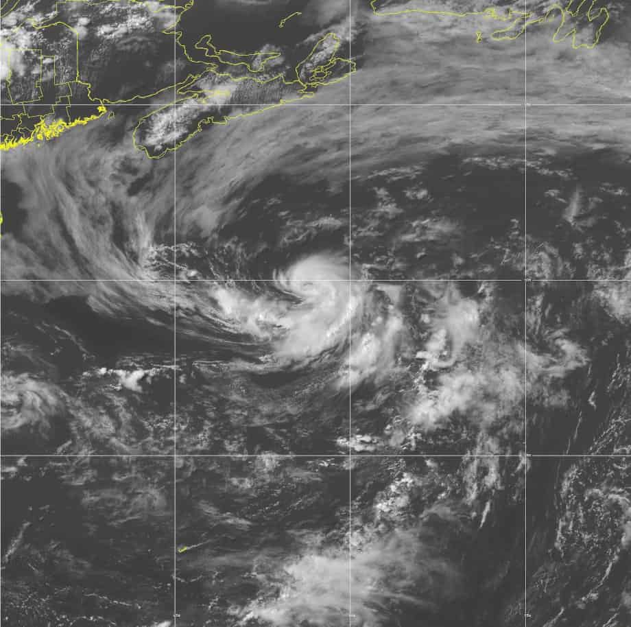
Category 3 Hurricane Teddy in the central Atlantic Ocean with a well-defined eye and significant banding. Teddy will reach Bermuda on Monday, though the exact track is still unknown.
Second Major Hurricane of the Season Aims for Bermuda
Update 5:30 PM CDT: Hurricane Teddy is now a Category 4 Major Hurricane with 140 MPH sustained winds. The NHC forecast calls for additional strengthening over the next 24 hours to at least 150 MPH. Category 5 is not out of reach for Teddy.
Depression Twenty formed over the tropical Atlantic Ocean on Saturday, September 12. Forecasters expected gradual strengthening as the cyclone moved northwest over warm water and an area of decreasing wind shear. By late Saturday, the National Hurricane Center issued its first public advisory and warned that Teddy would become a tropical storm by the next day (Sunday) and a hurricane within a few days—the nineteenth named storm of the 2020 Hurricane Season and the earliest “T” storm on record.
In the 5:00 PM update on Sunday, the forecast expected Depression Twenty to become a tropical storm that night and had the potential for a Major Hurricane.
10 Tips to Survive a Hurricane Disaster
Twelve hours later, Depression Twenty was named Tropical Storm Teddy and the likelihood that it would become a major hurricane had increased. In the 5:00 PM Advisory on Monday, the forecast track and cone of uncertainty showed a path toward Bermuda with an intensity increase to a major hurricane by Thursday, September 17.
By Wednesday evening, Teddy was a Category 1 Hurricane with 90 MPH sustained winds as it began rapid intensification. Seven hours later at 5:00 AM Atlantic Standard Time, the storm had increased to Category 2 with 105 MPH winds and stronger gusts. By 11:00 AM, Teddy was at Category 3 with 120 MPH wind. Bermuda, still recovering after taking a direct hit from Hurricane Paulette, was still in Teddy’s path.
Hurricane #Teddy Advisory 21: Teddy Becomes a Major Hurricane. Swells Forecast to Spread Across the Southwestern Atlantic Into This Weekend Increasing Rip Current Threat. https://t.co/VqHn0u1vgc
— National Hurricane Center (@NHC_Atlantic) September 17, 2020
11 AM AST Hurricane #Teddy key messages. #Teddy has strengthened into a major hurricane, and interests in Bermuda should monitor forecast updates as the risk of impacts is increasing. More: https://t.co/tW4KeFW0gB pic.twitter.com/ke6McJhPb8
— National Hurricane Center (@NHC_Atlantic) September 17, 2020

Hurricane Teddy Threats and Hazards
Hurricane Teddy’s present forecast track remains uncertain for Bermuda. The forecast for the Major Hurricane has considerable error and could pass 150 miles or more to either side of the islands, or it could make a direct hit. Teddy should weaken before reaches Bermuda Sunday night or Monday morning, but it will be still be a category 3 or category 2 hurricane. The five-day forecast is always uncertain. Much could change between today (Thursday, September 17) and Monday, September 21.
As powerful category 3 storm, with the possibility for category 4 tonight, Teddy will churn out high seas and rip currents throughout the southwest Atlantic over the weekend. The hurricane-force wind field is about 70 miles across, tropical storm winds in an area 400 miles wide.
The Best Natural Gas Generator for Whole House Power
Teddy’s track this morning moves it south of Bermuda, then north before it begins to turn northeast. Bermuda residents, businesses, and tourists should monitor the storm over the weekend as it approaches the islands.

National Hurricane Center 2 day tropical weather outlook for September 17, 2020. The next system to watch is the low pressure area in the southwestern Gulf of Mexico which could become Tropical Storm or Hurricane Wilfred in the next few days.
New System Threatens Gulf Coast—Could Become Wilfred
A well-defined low-pressure system over the southwestern Gulf of Mexico is scheduled for reconnaissance by a hurricane hunter aircraft this afternoon. Upper level winds are conducive for development. The National Hurricane Center give it a 90 percent chance to form a depression or tropical storm later today or tomorrow. The system or depression will meander for a day or two before turning to the north northeast by Saturday.
How to Use a Portable Generator for Emergency Power
The system has a wide area of open circulation with increasing thunderstorms. If the system becomes a tropical storm, it will be named Wilfred. Wilfred is the last name in the 2020 list. After Wilfred, the NHC will assign Greek letters starting with Alpha to additional storms.
Life Threatening Storm Surge is No Joke
Video of Gulf Breeze, Florida on east bay getting rocked!! Video Via Katie Felman pic.twitter.com/1WC7hr23ZS
— Jim Cantore (@JimCantore) September 16, 2020
Other Atlantic Storms and Systems
Regardless of a depression or tropical storm forming in the Gulf over the next few days, high activity levels remain in the rest of the Atlantic. A low-pressure system south of the Cape Verde Islands shows signs of development. The NHC gives this system a 60 percent chance of further development over the next five days.
Another low-pressure system to the north near the Azores has a lower (30 percent) chance of formation.
Hurricane Preparedness—Make a Plan
An area of convection and low pressure over Africa will emerge onto the Atlantic in a few days. Each system that moves over this tropical region has the potential for development if the conditions are right.
In any case, it is likely that forecasters will assign the name Wilfred to a storm sometime in the next week.
Meanwhile, Hurricane Sally has degenerated to a Post-Tropical Cyclone over Georgia. Vicky is now a depression with just one day showing in its forecast. Vicky will likely dissipate or be absorbed within the next 24 to 36 hours.


