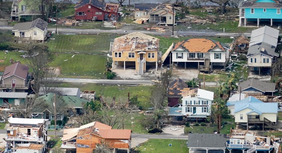
Damage from Hurricane Laura. The Louisiana and the Central Gulf Coast Struggle to Recover During After Multiple Storms Beginning with Cristobal Hit the Region.
Louisiana–Mississippi–Alabama Back in the Crosshairs as Zeta Leaves Mexico
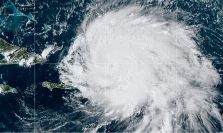
Hurricane Zeta has moved off the Yucatan Peninsula and into the Gulf. Currently at Tropical Storm strength with 65 MPH sustained winds, Zeta will be a Category 1 Hurricane before 10 PM Central Time. Tropical Storm force winds extend 100 Miles from the center making this a 200-mile-wide storm as of this morning. Hurricane Zeta is the eleventh hurricane and twenty-seventh named storm of the record breaking 2020 Atlantic Hurricane Season.
The National Hurricane Center issued Hurricane Warnings from Louisiana to portions of Alabama, and Tropical Storm warnings for Texas, Louisiana, Mississippi, and Florida.
Zeta will gain strength as it crosses the Gulf of Mexico and heads for the Central Gulf Coast. The storm track could change in the next 24 hours. Some weakening may take place as the hurricane nears the Coast, but landfall could include 80 MPH wind and gusts up to 100 MPH hour.
Automatic Standby Generators for Power Outages
The current track has it crossing over or near the Mississippi River Delta about 7:00 PM CDT on Wednesday, October 28th. A second landfall near Biloxi, possibly with reduced strength, will occur not long after. Zeta is moving at 12 MPH and may move faster as it crosses the Gulf.
Zeta is not a large storm or very strong, but residents in the warning and watch areas should put their hurricane preparedness plan into action.
A Storm Surge Warning is in effect for #Zeta from Intracoastal City, LA to Navarre, FL, including adjacent bays and lakes. Maximum inundation could be as high as 5-8 ft above ground level along portions of the Mississippi and Alabama coasts.https://t.co/ONQXCoqnfn pic.twitter.com/1nZ7waiJiB
— National Hurricane Center (@NHC_Atlantic) October 27, 2020
Storm Surge is a mound of water that moves with the storm and is highest just ahead of the eye. Strong wind circling the eye pushes the water ahead of the storm while low pressure near the center allows the water to rise as higher pressure away from the storm pushes down.
Hurricane Laura had a storm surge and wave damage above the 17 foot mark, as evidenced by damage to structures near the coast located well above ground level on piers.
Hurricane Zeta Key Messages from the National Hurricane Center

Life threatening storm surge will bring water well above normal with the highest levels of three to six feet between the Pearl River and Dauphin Island, Alabama. Lessor storm surge of one to three feet is possible across the Gulf Coast including the Florida Panhandle and Florida Peninsula. Low lying areas, estuaries, rivers, and creeks are vulnerable to a surge that moves inland with the storm.
Zeta is a fast-moving hurricane which helps limit the duration of impacts. Heavy rain will cause inland flooding along creeks, rivers, and lakes. The storm could spawn tornadoes, a common occurrence when hurricanes make landfall and as the storm moves inland.
Portable Generators for Backup Power
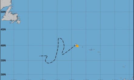
The hurricane will move through the United States on northeast path that takes it through Mississippi, Alabama, Tennessee, and Virginia before it emerges over the Atlantic Ocean late on Friday. Zeta could retain tropical characteristics as a depression with 35 MPH wind and heavy rain, even as it nears Wilmington, Virginia. Along the way it will leave up to eight inches of rain in many places, with local amounts up to 12 inches.
Tropical systems can trigger winter weather in the right conditions. One such case was Hurricane Sandy when it dumped up to three feet of heavy, wet snow in mountainous regions and collapsed roofs. In 2005, Hurricane Wilma brought 20 inches of snow across Pennsylvania and New England.
If Hurricane Zeta meets the cold front coming out of the Great Lakes on Thursday and Friday, rain could turn to a mix of rain and snow or possibly heavy snowfall in higher elevations.
All these factors could lead to power outages from Louisiana and Mississippi all the way through Virginia and across New England.

OVER THE GULF OF MEXICO - Sunset on Oct. 26, 2020 seen from 45,000ft aboard @NOAA Gulfstream IV-SP #NOAA49 “Gonzo” during Hurricane #Zeta mission. Credit: Quinn Kalen, NOAA.
— NOAA Aircraft Operations Center (@NOAA_HurrHunter) October 27, 2020
Visit https://t.co/MhVyAQiGZp for resources and follow @NHC_Atlantic for latest forecast. #FlyNOAA pic.twitter.com/SykcvkMVA4
Backfeeding is the practice of using a portable generator to supply electricity to a home through an outlet & homemade cord. It puts utility workers' in danger when they're working to restore service. This article from @NorwallPowerSys explains why. https://t.co/yFzVVmp6M1 pic.twitter.com/ziy6r8PYR6
— Huntsville Utilities (@HSVUtilities) August 21, 2020
This #TimelapseTuesday imagery from #GOESEast shows the last 12 hours of weather over North America in 22 seconds. We see #Zeta make landfall on the Yucatan Peninsula along with the lightning associated with a winter storm moving across the southern Plains. pic.twitter.com/dJzF7kb6dd
— NOAA Satellites (@NOAASatellites) October 27, 2020


