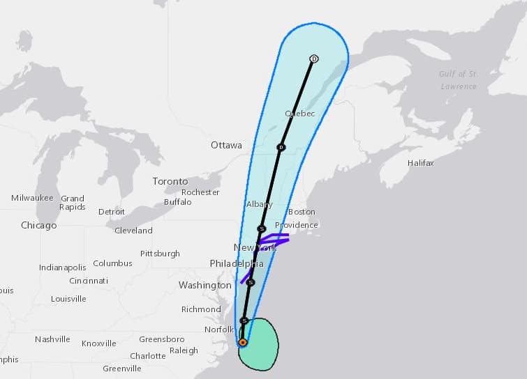
Earliest Fifth Named Storm Since the 1960s
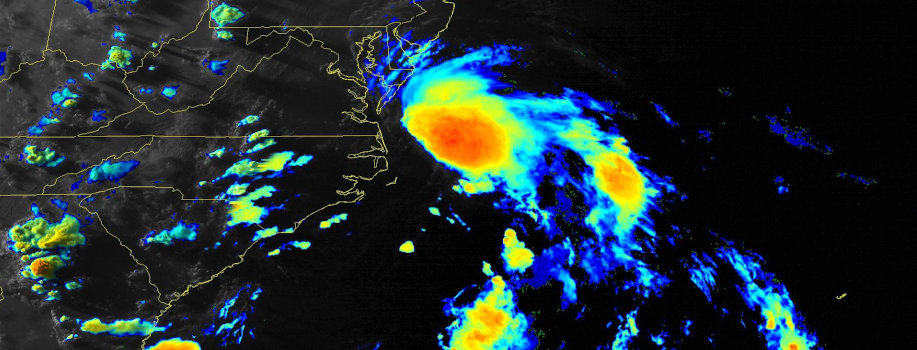
A low-pressure system along the Gulf Coast crossed Florida and the Southeast States over the Fourth of July weekend. After it emerged over the Atlantic Ocean this week, slow but steady development and organization formed into Tropical Storm Fay, the sixth named stormed of the 2020 Atlantic Hurricane Season.
Fay is the earliest F-Named storm since the first satellites in the 1960s. The tropical storm unseats Franklin from July 21, 2005—the same year that produced Hurricane Katrina. Fay follows on the heels of Tropical Storm Edouard, another record-breaker as the earliest E-named storm. The NHC track indicates Fay will take a slightly east of north track along New Jersey into New York and Connecticut. Dolly was the second earliest D-named storm.
A tropical storm warning is issued for New Jersey, New York including Long Island, and Connecticut. New Jersey, New York, and New England residents should expect rough seas, heavy rain, and gusty winds. The storm could bring enough rain to stave off a drought with 1 to 3 inches of rain with up to four inches in some areas.
Further development is unlikely, through it may remain a tropical storm through Maine and into Quebec.
Home Generators for Backup Power
Hurricane Season Off to a Fast Start

With six named storms in the books by the second third week of July, the 2020 hurricane season may break more records before it is over. Forecasters predict up to 20 named storms this year in what has already become another year of record-breaking storms.
Another developing system could set up another tropical storm over the next ten days.
In early June, Tropical Storm Cristobal broke a number of records. First by becoming the earliest C-named storm in history, then it crashed into the Gulf Coast and barreled its way through the Midwest including Illinois, Iowa, Minnesota, Wisconsin, and Upper Michigan. Cristobal remained a tropical storm throughout its journey into the heartland. Warm weather and saturated ground may have aided the storm’s ability to maintain strength through Michigan.
Prior to Cristobal, Tropical Storms Bertha and Arthur formed before the official start of the Hurricane Season. TS Arthur was named on May 18. Ten days later, TS Bertha formed on May 28. Tropical Cyclones can form at any time of year but are most common from June 1 to November 30. Two named storms in May is an unusual event.
Hurricane Preparedness: Make a Plan
Gonzalo and Hanna: The Next Two Storms

With up to 11 hurricanes and 6 major hurricanes in the forecast, the next named storms could become hurricanes. Gonzalo and Hanna are the next two names in the 2020 list. The United States could see either or both of those storms make landfall anywhere along the Gulf or East Coast.
Meanwhile, the Saharan Dust Cloud that helped keep the Caribbean and Gulf quiet at the end of June continues to dissipate. Wind shear in the region, another factor that limits tropical development, has decreased.
Anyone living along the coast should prepare for a hurricane. The next three months could bring the development of up to 14 hurricanes, major hurricanes, and tropical storms. As many as 5 in a single month. The hurricane season peaks from the end of July through October.


