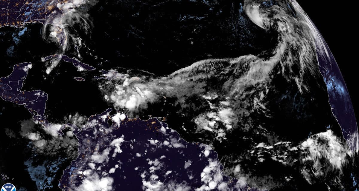
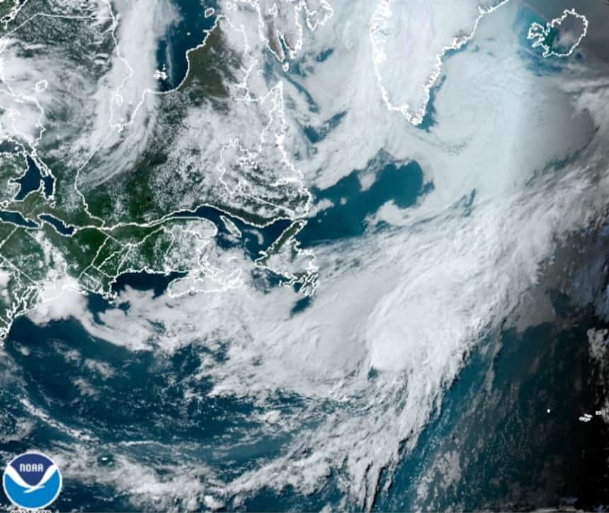
A GOES 16 satellite view of the tropical Atlantic Ocean, Gulf of Mexico, and Caribbean Sea showing Tropical Storm Theta in the upper right, Tropical Storm Eta in theGulf off the coast of Florida, and a new Tropical Wave in the Caribbean likely to become a tropical storm or hurricane later this week.
29th Named Storm of the 2020 Atlantic Hurricane Season
The 2020 Atlantic Hurricane Season has broken another record by adding another tropical storm. The 29th named storm is the most ever in a single season and the first time the Greek Letter Theta has been used to name a storm. Theta is currently located about 900 miles east of the Canary Islands, moving north by northeast. If the current forecast for the storm’s path and evolution does not change, Theta poses little threat to land.
However, the 2020 Atlantic Hurricane Season has proven difficult to forecast and predict at times. Storms change direction or don’t move as expected. Hurricane’s Marco and Laura were expected to hit the coast of Louisiana at nearly the same time. Marco was considered the bigger threat and Laura the lessor.
Best Natural Gas or Propane Generators for Hurricanes
Forecasts are based on multiple computer models, each with different strategies for predicting cyclone formation, strength, and path.
Today, Tropical Storm Theta could pose little risk to land and dissipate in five days after weakening to a depression. Tomorrow, the models could change and predict strengthening to a hurricane before it hits the Canary Islands. Instead of landfalling as a weak tropical storm, Hurricane Laura strengthened to a major hurricane with 150 MPH sustained winds and 185 MPH Gusts. The slow movement and timing brought increased wind damage, and a storm surge over 17 feet above normal levels.
Tropical Storm Eta is another storm that has not behaved as expected.
With the formation of #Theta, 2020 Atlantic #HurricaneSeason takes infamous top spot for busiest on record:
— NOAA (@NOAA) November 10, 2020
More at: https://t.co/Sb60WbgL4U@NWS @NHC_Atlantic pic.twitter.com/3Xo5zMJzp6


Tropical Storm Theta in the East Central Atlantic Ocean
Tropical Storm Eta
Eta first hit Nicaragua and Honduras as a Major Hurricane that churned over land much longe than initially expected. It then exited Central America as a depression. Over the Caribbean Sea, it gained strength before it crossed Cuba to the Straits of Florida. In the straits, a slow curving path into the Florida Panhandle was expected. Instead, Eta meandered for two days before taking a path up the Peninsula.
It’s Never Too Late to Start Hurricane Preparedness
If nothing changes, Eta will make landfall north of Homasassa Springs, Florida on the Peninsula as a strong tropical storm with 65 MPH winds. At 7:35 EST on Wednesday, November 11, Eta was upgraded to a hurricane with 75 MPH winds as noted by Doppler Radar and confirmed by a hurricane hunter aircraft. By 1:00 PM, the storm had weakened again to a tropical storm with 70 MPH wind.
4 PM EST Nov. 11th Key Messages for Tropical Storm #Eta:
— National Hurricane Center (@NHC_Atlantic) November 11, 2020
Tropical storm force winds still expected this evening along the Florida Gulf Coast. Heavy rainfall will continue to spread across west & central Florida. Additional flash & urban flooding possible in south Florida too. pic.twitter.com/WpQNhdK7iy

Caribbean Tropical Wave
A Tropical Wave in the Eastern Caribbean Sea has begun to organize as it moves into a region more conducive to tropical cyclone formation. The National Hurricane Center expects this tropical wave to form into a tropical cyclone late this week or over the weekend. If the wave forms into a cyclone and reaches tropical storm strength, the next name on the Greek Alphabet list is Iota. Current forecasting models show Iota moving toward Honduras on much the same path as Hurricane Eta.


