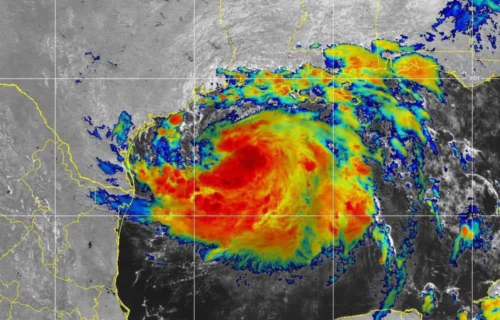
Tropical Storm Hanna Approaches the Texas Gulf Coast
NOAA GOES EAST Satellite Image
Tropical Storm Hanna the Earliest Eighth Named Storm of the Season
Tropical Depression Eight organized into Tropical Storm Hanna late Thursday Night over the central Gulf of Mexico. Hurricane Hunter aircraft investigating the storm found its position slightly north of where expected. Forecasts project Hanna to make landfall just south of Corpus Christi, Texas late Saturday afternoon or early evening.
Hanna is the eighth named storm of the 2020 Hurricane Season and the earliest eighth storm on record. The storm will continue to intensify as it approaches the coast. At landfall, sustained wind speeds might reach 70 MPH—nearly category 1 (75 MPH) hurricane force. After landfall, Hanna will weaken gradually, but maintain tropical storm strength through early Sunday morning.
Did You Complete Your Hurricane Preparedness Plan?
Winds from 60 to 70 MPH will cause moderate wind damage to trees and some buildings. With heavy or even torrential rain in the forecast, Governor Abbot issued a statement for Texas residents to remain vigilant and prepare for flash flooding and heavy rain.
The NHC issued Tropical Storm Warnings from the southern tip of Galveston Island to the Mexican Border. Residents can expect locally heavy rainfall totals up to 12 inches, with lessor amounts away from the storm center. Gulf Coast areas from Galveston to Florida expect 1-2 inches with some higher totals reaching four inches. Power Outages are expected.
Lack of time before landfall limits the storm’s ability to strengthen. Warm Gulf water over 80 degrees and favorable conditions could allow the storm to briefly become a hurricane with 75 MPH winds before it reaches land.

Forecast Path of Tropical Storm Hanna and Storm Warnings on the Texas Coast
National Hurricane Center Graphic
Gonzalo Heads for Windward Islands Amid Unfavorable Conditions
Surrounded by dry air and dust from the Sahara Desert, Tropical Storm Gonzalo probably won’t become the first hurricane of the season. Strong wind shear will prevent further development near the Windward Islands and Caribbean Sea. Forecasts now call for substantial weakening. Strong wind shear could shred the tiny tropical storm and it could dissipate entirely as it passes south of Cuba. If the track moves it further south over the Caribbean, interference from South America could further weaken the storm.
Top Ten Tips to Survive a Hurricane Disaster
Gonzalo will bring rough seas, gusty winds up to 60 or 70 MPH, and heavy rain from Grenada to Saint Lucia and Barbados. Impacts include wind damage, flash flooding, storm surge, and power outages. Heavy rain up to six inches with 2-4 inches in most places. If enough rain falls in the right locations, mudslides could result.

As Tropical Storm Gonzalo Heads for the Windward Islands of Barbados, Grenada, St. Lucia, another Cape Verde Tropical Wave has a moderage chance of development in the next five days.
NOAA GOES EAST Satellite Image
Cape Verde Tropical Wave Development Potential
A tropical wave south of the Cape Verde Islands off the coast of Africa has the potential for tropical development. Tropical Storm Gonzalo was the first Cape Verde system to develop. This tropical wave will follow the same path to the Western Atlantic where conditions are favorable for development to a Tropical Depression or Storm sometime next week.
Portable Generators for Emergencies
Eight weeks into the Atlantic Hurricane Season, eight named storms have formed. The season peak is seven weeks away and four months remaining until hurricane season ends on November 30. Considering the early start with two named storms before the season began, it might not be a stretch to expect a storm or two after the season ends.


