Rare Duet of Tropical Cyclones to Hit Louisiana on Monday and Wednesday
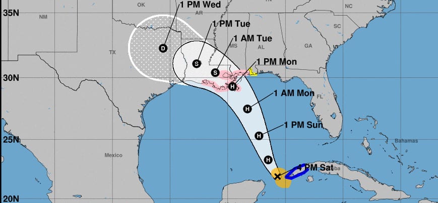
Two tropical storms will strengthen into hurricanes before making landfall on the Gulf Coast. All Gulf Coast Residents from the Florida Panhandle to Texas should activate their Hurricane Preparedness Plan. Hurricane Marco will landfall in Louisiana on Monday and Laura in Louisiana on Wednesday. The speed, direction, and intensity of these two storms has changed markedly in the last 48 hours.
Governor John Edwards Declares State of Emergency for Louisiana
Two hurricanes making landfall in the same general location is relatively rare and could turn into a recipe for a prolonged period of hurricane conditions from Florida to Texas taking place from Sunday afternoon through Wednesday Evening. Storm Surge, Flooding, and Wind Damage, Tornadoes and Widespread Power Outages are expected.
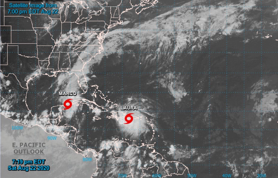
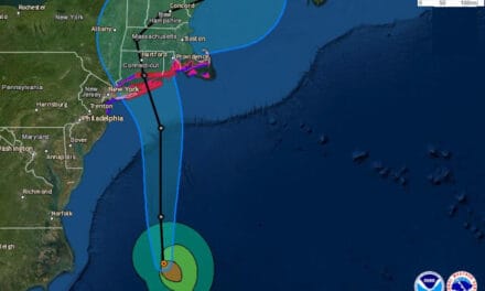
Marco and Laura started as Tropical Depressions in the eastern Atlantic earlier this week. Marco was ahead of Laura and the first to reach the Caribbean but took longer to organize into a tropical storm. As Marco enters the Gulf today near Cancun, may reach hurricane strength tonight or early Sunday morning. Hurricane and Storm Surge Watches are in effect from Pensacola, Florida to Beaumont, Texas. Wind shear will help limit strengthening, but Marco will reach the coast as a category 1 hurricane.
For more local information on effects from Tropical Storm #Marco, please follow @NWSHouston @NWSShreveport @NWSJacksonMS @NWSBirmingham @NWSLakeCharles @NWSNewOrleans @NWSMobile @NWSTallahassee pic.twitter.com/nOdGeoD4fR
— National Hurricane Center (@NHC_Atlantic) August 22, 2020
Marco just before strengthening to a hurricane as it enters the Gulf of Mexico on its way to Louisiana
Laura has slowed on its journey along the corridor just north of the major Caribbean islands and through the Straights of Florida. Once forecast to reach the Gulf Coast within hours of Marco, Laura will deal a second blow to New Orleans on Wednesday, August 26th, possibly as a stronger hurricane.
Puerto Rico is currently experiencing heavy rain and tropical-storm force winds of 60 MPH. Tropical Storm Warnings in effect for Puerto Rico through Cuba and the Bahamas. Tropical Storm Watches in effect from the Bahamas through the Florida Keys.
Best Portable Generators for Emergency Power
Laura’s current forecast track takes it directly over the Dominican Republic and Haiti, and then the full length of Cuba before it emerges over the Gulf of Mexico.

Laura, still a tropical storm, makes it way through the Caribbean on it’s way to the Gulf of Mexico and Louisiana
Key Messages for Hurricane Marco and Laura
- Marco’s Tropical-Storm-Force winds will arrive in Louisiana Sunday evening and continue through Monday.
- Hurricane and Storm Watches are in effect from Pensacola, Florida through Beaumont, Texas. All residents and businesses in the watch area should follow advice from local officials.
- The forecast track for Marco takes it northwest across Louisiana and into Texas as a tropical storm. Expect widespread flooding, heavy rain, and power outages across the region.
- The landfall of Hurricane Laura is still uncertain and could change as the storm moves across Cuba and into the Gulf.
Automatic Standby Generators Start and Run During Hurricanes
- Laura’s Tropical-Storm-Force winds begin to arrive in the Florida Keys on Monday and Louisiana on Tuesday. Laura’s wind and rain should depart sometime on Wednesday.
- Laura will turn north shortly before landfall and continue this track through Arkansas and Mississippi.
- Gulf Coast residents and businesses should monitor the progress of both storms through social media, local news, the National Hurricane Center, and local officials.
National Hurricane Center on Twitter


