The forecast track of Hurricane Henri on August 21, 2021. Hurricane Henri makes landfall on Long Island and Connecticut on Sunday, August 22, 2021. NHC Graphic.
East Coast and New England Prepare for Storm Surge, Wind, Rain, and Dangerous Surf and Rip Currents
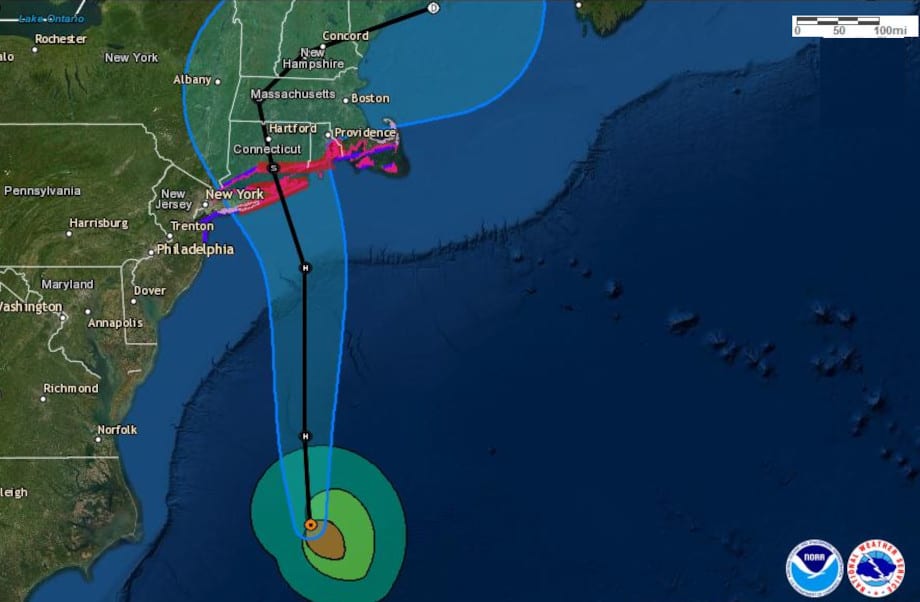
Update August 21, 2:00 PM. The NHC upgraded Henri to a Hurricane. Henri makes landfall before 2:00 PM on Sunday near the Town of Southhampton, on Long Island and crosses the Long Island Sound for a second landfall near the Town of Madison, Connecticut. Hurricane Warnings in effect from West Babylong and Port Jefferson Harbor, Long Island East to Block Island, and from New Haven, Connecticut east to the Rhode Island-Massachusetts Border. Dangerous Storm Surges expected with watches and warnings that encompass the entire Long Island Shore, Long Island Sound, and waterways, Rhode Island, Massachusetts and Nantucket Sound. Cape Cod Bay is under a Storm Surge Watch. Storm Surge could begin late tonight/early tomorrow morning. Expect heavy rain, flash flooding, inland flooding, winds of 80 MPH and gusting to 100 MPH or more. Widespread power outages are possible. Charge phones, keep flashlights with extra batteries. Buy ice for refrigerators.
New York Governor Cumomo declared a state of emergency in advance of Hurricane Henri’s landfall. Follow advice from local officials. Rush to complete hurricane plan preparations.
A State of Emergency has been declared for counties in NYC, Long Island, the Capital Region, and the lower Hudson Valley ahead of #HurricaneHenri.
— State of New York 😷 (@NYGov) August 21, 2021
New Yorkers are urged to prepare for heavy rain, strong winds and power outages.https://t.co/m0bGbEbz1Q
—End Update 21-August-2021–
Tropical Storm Henri, currently about 700 miles east of Daytona Beach, Florida, is moving west as it gradually turns north before becoming a hurricane on Friday evening, August 20. Henri is the eighth named storm of the 2021 Atlantic Hurricane Season.
Most forecasters agree that Henri becomes a hurricane Friday evening. Meanwhile, the Tropical Storm will create heavy surf around Bermuda through the weekend as it moves west and north of the island.
The National Hurricane Center forecast calls for Henri to turn north by northeast Friday evening and pass within 200 miles of Cape Hatteras North Carolina on Saturday. Hurricanes produce dangerous rip currents and heavy surf conditions even when hundreds of miles offshore. The waves attract surfers and beach goers, but the dangerous currents take lives every year. Life threatening surf and rip currents will reach most of the East Coast and Atlantic Canada on Friday and through the weekend.
2021 Hurricane Season Preparedness
By Sunday, Henri is forecast to near the East Coast with storm surge, wind, and rain in portions of southern New England and eastern Long Island. The National Hurricane Center expects to issue Watches and Warnings on Friday.
Computer models point to Henri reaching the New England coast on Monday, August 23, as a hurricane or possibly a strong tropical storm. A landfall between Long Island and Cape Cod is possible before Henri turns northeast away from land. However, forecasts beyond three days are open to interpretation. Henri could make landfall sooner or in another location.
The National Hurricane Center expects to issue Watches and Warnings on Friday.
Tropical Cyclone Risk Assessment Important to Hurricane Preparedness Planning
#Henri has strengthened to a hurricane and is headed for Long Island and southern New England. Hurricane and Tropical Storm Warnings have been extended eastward. Here are the 11 am EDT Key Messages. See https://t.co/tW4KeFW0gB for details. pic.twitter.com/lRb61AnHaj
— National Hurricane Center (@NHC_Atlantic) August 21, 2021
We just flew over the East Coast and saw #HurricaneHenri. Stay safe, friends. pic.twitter.com/o83XZAqDgR
— Megan McArthur (@Astro_Megan) August 21, 2021
200 PM EDT Wed 8/18: Seas associated with Tropical Storm #Henri are currently 20 ft, and are expected to build to 24 ft by Thursday evening. Swells from Henri could reach much of the U.S. east coast by the end of the week pic.twitter.com/T38OPP5Ec3
— NHC_TAFB (@NHC_TAFB) August 18, 2021
New at Norwall: DuroMax Portable Generators https://t.co/i4lnYmX5fM via @NorwallPowerSys
— Norwall PowerSystems (@NorwallPowerSys) August 13, 2021
#Henri is now a hurricane - the 3rd of the 2021 Atlantic hurricane season to date. This is the first tim since 2012 that the Atlantic has has 3+ hurricanes by August 21. pic.twitter.com/IscYmptxjG
— Philip Klotzbach (@philklotzbach) August 21, 2021

Hurricane Henri (upper right) over the Atlantic Ocean and Hurricane Grace (lower left) over the Yucantan Peninsula on August 19, 2021.
Active Hurricane Season Reaches Peak in Mid-September
The Hurricane Season Peak is three weeks away. Forecasters are watching tropical waves over Africa as they move west. Throughout the tropics, convective energy abounds from the Central Pacific through the Gulf of Mexico.
Need to Know: Standby Generator vs Portable Generator for a Power Outage
The waters of the Gulf of Mexico, Caribbean Sea, and Bay of Campeche have high oceanic heat content which contributes to storm formation and development, making them another source of tropical activity over the next three months. Last year, Hurricane Iota became the most powerful storm of the Atlantic Hurricane Season on November 16, reaching category 5 with 165 MPH winds and 200 MPH gusts. Iota started as a depression over the central Caribbean Seas, underwent rapid intensification, and hit Nicaragua on November 16.
Three active systems are currently on the maps. Post-tropical cyclone Fred is now a remnant over New York State. Advisories on Fred are now issued by the Weather Prediction Center.
DuroMax Generators: Features and Benefits
Hurricane Grace is over the Yucatan Peninsula on westward track for the Bay of Campeche and mainland Mexico. It will dissipate over Mexico to a post-tropical cyclone before reaching the Pacific Ocean where conditions are conducive for development into a tropical depression or storm.
Henri is a tropical storm located southeast of Cape Hatteras, North Carolina. Impacts to the East Coast and New England will start tomorrow through the weekend and early next week.
#Grace now has 80 mph winds and #Henri has 70 mph winds. The last time that the Atlantic had two 70+ mph named storms simultaneously this far west in the Atlantic (west of 67.5°W) this early in the calendar year (by August 18) was in 1901. #hurricane pic.twitter.com/ewv040tZaO
— Philip Klotzbach (@philklotzbach) August 18, 2021
Hurricane Preparedness
- Hurricane Hazards and Risk Factors
- Make a Hurricane Evacuation Plan
- Hurricane Preparedness Kits and Supplies
- Hurricane Insurance Checkup and Updates
- Prepare Your Home for Hurricanes
- Help Neighbors with Hurricane Preparedness
- Complete Your Hurricane Preparedness Plan
- Emergency Preparedness Tips
- How to Prepare for a Power Outage
- 10 Tips to Survive a Hurricane Disaster
- FEMA Recommends a Generator
- Hurricane Disaster Preparedness
New at Norwall: DuroMax Portable Generators https://t.co/i4lnYmX5fM via @NorwallPowerSys
— Norwall PowerSystems (@NorwallPowerSys) August 13, 2021
Hurricane Grace to Hit Cayman Islands, Cancun, and Mainland Mexico https://t.co/oOIIytFl3X pic.twitter.com/fC2FRw8esO
— Norwall PowerSystems (@NorwallPowerSys) August 18, 2021


