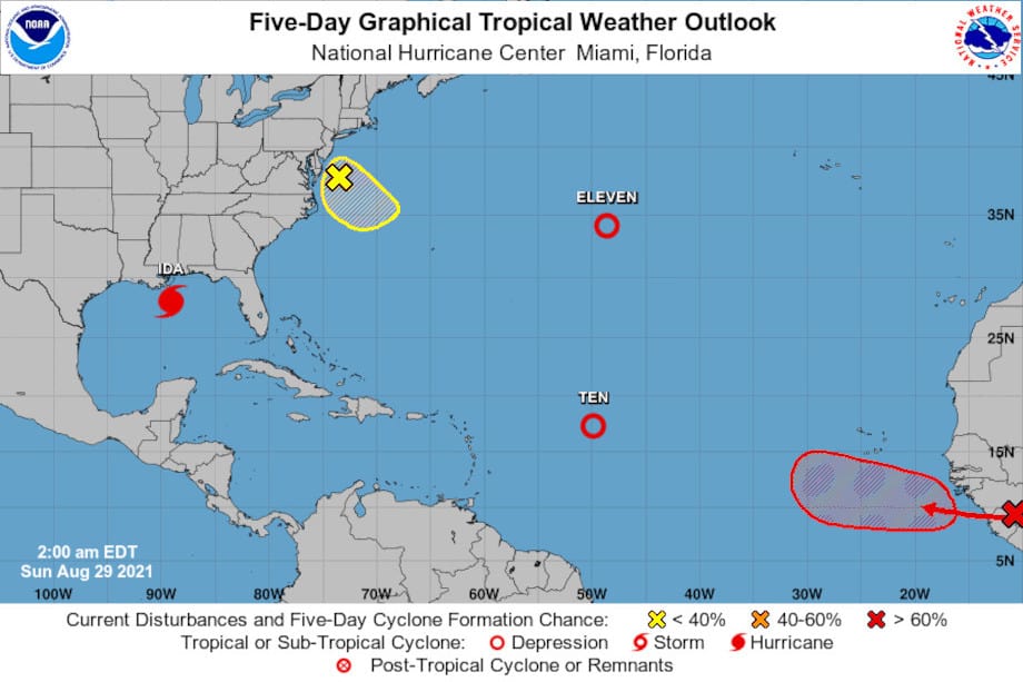
Nearly Two Weeks before the Atlantic Hurricane Season Peak, the basin has two depressions, a major hurricane about to make landfall, and a tropical wave that will become the next hurricane of the 2021 Season. NOAA-NHC Graphic.
Tropical Storms Julian and Kate Come and Go as Hurricane Ida Devastates Louisiana
As Hurricane Ida turned all eyes on Louisiana and the Gulf Coast, Tropical Depression 10 formed in the early hours of Saturday, August 28, several hundred miles east of the Lesser Antilles islands. The depression moved into a region of strong upper level winds and cooler water, which limited further development.
Tropical Depression 11 formed late on the same day about five hundred miles to the north and midway between Virginia and Europe. It became Tropical Storm Julian the next morning. The storm posed no threat to land as it moved northeast. Over the colder waters of the Atlantic, Julian transitioned to an extra-tropical cyclone the next day and dissipated not long after.
Portable Generators for Home Backup During Outages
Another system of development formed off the East Coast near Chesapeake Bay about 2:00 in the morning on Sunday. A. The system had little chance of development and would dissipate by Monday.
A tropical wave moving off the coast of Africa had a high chance of formation over the next five days.
Hurricane Preparedness
- Hurricane Hazards and Risk Factors
- Make a Hurricane Evacuation Plan
- Hurricane Preparedness Kits and Supplies
- Hurricane Insurance Checkup and Updates
- Prepare Your Home for Hurricanes
- Help Neighbors with Hurricane Preparedness
- Complete Your Hurricane Preparedness Plan
- Emergency Preparedness Tips
- How to Prepare for a Power Outage
- 10 Tips to Survive a Hurricane Disaster
- FEMA Recommends a Generator
- Hurricane Disaster Preparedness

Tropical Storm Ida over Mississippi on August 30. Tropical Storm Julian formed and dissipated in a day, and Tropical Storm Kate is headed north. Two new systems form near Central America and the coast of Africa. NOAA Graphic.
Tropical Storm Kate
Tropical Depression 10 took its time to develop. Almost a day after Hurricane Ida made landfall as a category 4 major hurricane, 10 finally organized into Tropical Storm Kate on Monday morning, August 30. The tropical wave near the coast of Africa was moving offshore with an 80 percent chance of tropical development over the next five days. Hurricane Ida weakened to a Tropical Storm over Mississippi after causing catastrophic damage to southeast Louisiana.
The National Hurricane Center began watching yet another broad area of low pressure over the southeast Caribbean Sea along the Central American Coast. Forecasters at the NHC expected it move toward the Yucatan Peninsula just off the coast. It had no chance of development while near Panama, but chances would increase as it moved north.
The Best Natural Gas Generators for Hurricane Power Outages
Tropical Storm Kate moved north at a slow pace with winds at 40 MPH, just about the threshold for a tropical storm. Ida weakened further on Monday to a tropical depression as it turned northeast.
By Tuesday, the tropical wave moving off Africa had a 90 percent chance of tropical development over the next two days. Kate was in a region of strong wind shear, but maintained tropical storm strength for a short time. It then weakened to a depression.
Ida moved over Tennessee as a tropical depression. Ida left behind additional flooding following the flash floods the region is still recovering from. Many homes are being condemned following the major flooding that swept through the area.
The tropical wave off the African Coast organized into Tropical Depression Twelve in an environment that would encourage rapid development.

Tropical Storm Larry
While Tropical Depression Kate moved slowly north, Depression Twelve organized further into Tropical Storm Larry on Wednesday, September 1. Larry was growing and strengthening rapidly in an area of low shear over warm tropical water.
Forecasts for the area of low pressure in the southeast Caribbean Sea extended into the Gulf of Mexico with a track that crossed the Yucatan Peninsula into the Bay of Campeche. If the system stays over water, it will probably develop into a tropical cyclone over the next 5 days.
Tropical Depression Ida transitioned to an extra-tropical cyclone over West Virginia near the Virginia border as it leaves flooding and heavy rain along its path.
How to Use a Portable Generator for Home Power
As Ida reached the East Coast near Cape Cod late on Wednesday or early Thursday, Larry became a hurricane, the twelfth named storm of the Atlantic Hurricane Season and still more than a week before the season’s peak.
Hurricane Larry is currently on a track that points it toward Bermuda as a Category 4 Major Hurricane. Forecasts beyond three days are uncertain. Larry’s projected track could change dramatically over the next few days.
Another low-pressure area has now formed just off the coast of Africa. This area has a low chance of development over the next few days and into the next week as it moves west.
Areas of convection over the southern Caribbean Sea and East of the Lesser Antilles associated with Kate do not yet show signs of organization, but another system will move off the African Coast in the next few days.
Ida has now transitioned to a Tropical Rainstorm moving northeast across southern New England. Forecasts call for an additional 2-4 inches of rain.


