June 2 Hurricane Season Forecast Updates
The latest updates at start of the Atlantic Hurricane Season have a slight increase in the number of storms.
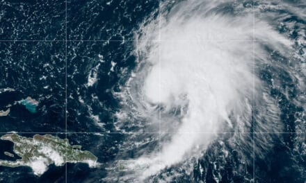
May, 2022, is the first season since 2014 that an early storm did not form. However, Eastern Pacific Hurricane Agatha made landfall on Mexico and crossed the mainland to the Gulf of Mexico where it began to reorganize on May 31 as Potential Tropical Cyclone One (PTC One.) With tropical storm force winds present, forecasters at the National Hurricane Center expected the system to become a tropical storm before landfall on Florida. Wind shear interfered with the organization and prevented full development.
2022 Atlantic Hurricane Season News and Updates
Despite lacking all the tropical characteristics of a cyclone, PTC One brought 50 MPH winds and dumped up to 12 inches of rain on Florida, resulting in flash flooding. The system also spawned several tornadoes.
After emerging over the Atlantic, PTC One completed organization and forecasters named it Tropical Storm Alex as it headed toward Bermuda.
The season forecast increases based on the same or enhanced factors from present in April.
- The Tropical Atlantic is warm with above average temperatures. The rest of the Atlantic, Caribbean, and Gulf of Mexico is warmer than average.
- A persistent La Niña in the equatorial Eastern Pacific Ocean (colder than normal temperatures.) In early spring, this area of the Pacific was colder than any year since 1999.
- The Atlantic Multi-Decadal Oscillation is in a positive phase.
| 2022 Forecast | April 2022 |
June 2022 | 30-Year Average |
| Named Storms | 19 | 20 | 14.4 |
| Hurricanes | 9 | 10 | 7.2 |
| Major Hurricanes | 4 | 5 | 3.2 |
| Accumulated Cyclone Energy* | 160 | 180 | 123 |
Based on forecasts from the Colorado State University Tropical Weather and Climate Research Department, Accuweather.com, and the National Oceanic and Atmospheric Administration.
Hurricane Preparedness
- Hurricane Hazards and Risk Factors
- Make a Hurricane Evacuation Plan
- Hurricane Preparedness Kits and Supplies
- Hurricane Insurance Checkup and Updates
- Prepare Your Home for Hurricanes
- Help Neighbors with Hurricane Preparedness
- Complete Your Hurricane Preparedness Plan
- Emergency Preparedness Tips
- How to Prepare for a Power Outage
- 10 Tips to Survive a Hurricane Disaster
- FEMA Recommends a Generator
- Hurricane Disaster Preparedness

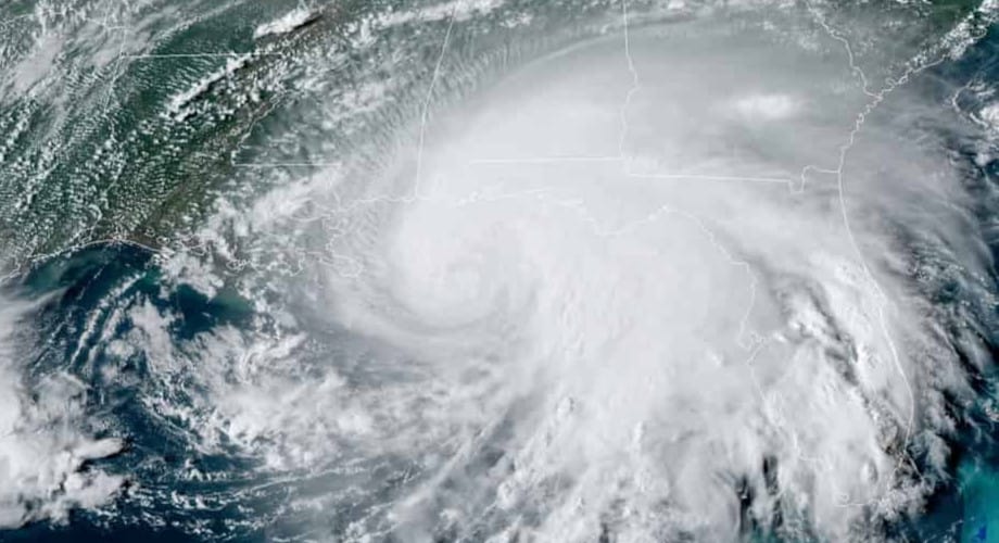
Hurricane Ida about to make landfall on southeast Louisiana, August 29, 2021. Ida downed all the major transmission lines into New Orleans and the surrounding region, forcing the local utility to use two small generating plants to power critical infrastruction. NOAA Satellite Photo.
Do You Know
Minimum Food and Water for Three days includes non-perishable food and three gallons of water per person and each pet.
*ACE is the potential for wind and storm surge destruction defined as the sum of the square of a named storm’s maximum wind speed in knots. (Colorado State University Tropical Weather and Climate Research)
The next forecast updates are scheduled for the first week of July and the first week of August.
Season Forecast Updates: April 2022
Preparations Under Way for the Above Average Season Ahead
In April, we received forecast updates from the NOAA, Colorado State University, and Accuweather. In general, the organizations agree that 2022 looks like the seventh consecutive above average season. Hurricane Season officially starts on June 1 and runs though November 30. Early activity, especially in a year with an above average forecast, is not unusual.
- The 2020 Season was the most active year on record with 31 storms.
- 2021 turned into the third most active season.
- 2022 has the potential to exceed the 2021 season.
Three factors point to above average activity this year.
- The Atlantic Ocean is near average temperatures.
- The Caribbean is warmer than average.
- Coldest April Equatorial Pacific Ocean (La Nina) since 1999
- A positive Atlantic Multi-Decadal Oscillation.
Forecasts change. As the season approaches and gets underwear, forecasting organizations will update their forecasts to reflect the most recent data. We expect the next update in early June as the 2022 Atlantic Hurricane Season gets underway.
| April Forecast | 2022 | 30-Year Average |
| Named Storms | 19-20 | 14.4 |
| Hurricanes | 8-9 | 7.2 |
| Major Hurricanes | 3-5 | 3.2 |
| Accumulated Cyclone Energy* | 160 | 123 |
*ACE is the potential for wind and storm surge destruction defined as the sum of the square of a named storm’s maximum wind speed in knots. (Colorado State University Tropical Weather and Climate Research)
Warm Atlantic Ocean Temperatures + Cooler Eastern Pacific Points to Active 2022 Season
Each year in the weeks following the end of the Atlantic Hurricane Season, the Colorado State University Tropical Weather & Climate Research Department issues a qualitative discussion on the next season. The December discussion is not a forecast, but rather a discussion about what could take place in a season still more than six months away. CSU issues its first forecast in April and follows with updates just before and during the season.
The December tropical weather discussion gives a percentage chance for each of five scenarios based on two key parameters.
- The strength of the Atlantic Multi-Decadal Oscillation (AMO)
- The phase of the El Nino Southern Oscillation (ENSO) (El Nino / La Nina)
Following three quiet hurricane seasons from 2013-2015, the next six seasons from 2016-2020 included two hyperactive seasons for 2017 and 2020. Even though the North Atlantic Sea Surface Temperatures (SSTs) have trended below average in recent years, both in summer and winter, the above-average seasons leading up to 2021 give researchers at CSU confidence that the AMO will remain positive. A positive AMO indicates an active season.
The 2020 Atlantic Hurricane Season Set New Records
In December, the computer models used to predict the following year’s ENSO phase changes are usually in disagreement. The current phase is a moderate La Nina, which tends to promote increased Atlantic Basin activity. However, this could shift toward neutral (average sea temperatures) this summer and moving into fall. The chance of an El Nino forming appears low. In the past, two successive La Nina years shifted to neutral in the third year.

A La Nina Winter brings colder winter weather in the northern states. In the summer, the lack of dry air over the Atlantic promotes tropical cyclone development as shown in the left side, lower graphic. NOAA Graphic Image.
El Nino Southern Oscillation
It might appear counter-intuitive that the equatorial ocean temperatures in the Eastern Pacific influence the Atlantic Hurricane Season, but forecasters have known for some time that shifting sea temperatures in this region affect North America’s weather.
La Nina, the cooler phase, often leads to very cold winters across the northern part of the country and Canada. The current phase is La Nina and by mid-January, northern states had experienced numbing temperatures well below zero for days at a time. The cooler phase of the ENSO also indicates increased Atlantic Basin Tropical Cyclone Activity.
Prepare for Hurricane Power Outages with a Generator—FEMA
El Nino, the warmer phase, can lead to warmer winter weather in the north and less tropical cyclone activity in the Atlantic Basin during the summer and fall months. Forecasters believe the current La Nina phase will trend closer to neutral (60 percent chance) this summer and into fall, but formation of an El Nino is unlikely.

Shifting Sea Surface Temperatures in the Atlantic Multi-Decadal Oscillation.
Atlantic Multi-Decadal Oscillation
The typical AMO period is about 60 years with the range from 40-50 to 70-80 years. This usually means the Atlantic Basic will remain in a generally above average or below average state of tropical cyclone activity for 25-35 years. Within that range, however, there could be months or even two years when AMO conditions (SSTs, salinity, pressure, wind, and moisture) weaken or strengthen. Sea Surface temperatures and circulation of air around Bermuda (called the Bermuda-Azores Gyre) are two indicators of the AMO phase. A strong gyre brings cooler, dryer air across the Eastern Atlantic, which brings stronger trade winds, increased temperature gradients, and upper level westerly winds—all factors that inhibit tropical cyclone formation and intensification.
The AMO index is currently above normal, which indicates, for the purpose of early discussion, above average tropical activity in the Atlantic Basin for the 2022 Hurricane Season.
It only takes one hurricane or tropical storm to landfall near you to make it an active season for your home and family. Are You Prepared?

CSU Tropical Weather 2022 Hurricane Season Outlook
| AMO | ENSO | ACE | Chance |
| Very Strong | No El Niño | 170 | 25% |
| Above Average | No El Niño | 130 | 40% |
| Above Average | El Niño Develops | 80 | 15% |
| Below Average | No El Niño | 80 | 10% |
| Below Average | El Niño Develops | 50 | 10% |
ACE is a measurement of the energy used by a tropical cyclone by taking the square of the maximum wind speed every six hours and adding it to the total for that storm. The NOAA adds the storm totals to create an entire season and classify it as extremely active, above normal, near normal, and below normal.
With an estimated Accumulated Cyclone Energy, forecasters can predict how many storms the season will produce. It is important to note, however, that accuracy for weather prediction nearly six months in advance is very low and can only offer a glimpse of what could happen in the coming season.
| ACE | Named Storms | Hurricanes | Major Hurricanes |
| 170 | 14-17 | 9-11 | 4-5 |
| 130 | 12-15 | 6-8 | 2-3 |
| 80 | 8-11 | 3-5 | 1-2 |
| 50 | 5-7 | 2-3 | 0-1 |
In April 2021, the NOAA Climate Prediction Center updated their hurricane season averages from the years 1981-2010. The change reflects the start of a new decade in 2021 and uses the years 1991-2020 for calculating hurricane season averages.
The season averages have increased and now include:
| Named Storms | 14 (up from 12) |
| Hurricanes | 7 (up from 6) |
| Major Hurricanes (Category 3, 4, 5) | 3 (unchanged) |
Based on CSUs discussion and possible outcomes, the 2022 Atlantic Hurricane Season has a 65 percent chance for an average to above average season with at least 13-18 named storms, 6-11 hurricanes, 2-5 major hurricanes. A 35 percent chance exists for a below average season with 6-12 named storms, 2-5 hurricanes, and 0-2 major hurricanes.
Hurricane Sally nears Louisiana in September, 2020. NOAA Satellite Image.
Tropical Storm Risk
“The Tropical Storm Risk venture developed from the UK government-supported TSUNAMI initiative project on seasonal tropical cyclone prediction which ran from October 1998 to June 2000.” Today, TSR uses cutting edge science and technology to develop innovative products for decision making in business, government, and society related to tropical cyclones around the world.
The early 2020 Hurricane Season forecasts and discussions indicated average to above average activity with 12 or more named storms. The forecast changed several times in the coming months, increasing to 16 storms in April, 19 in June, and 24 in August. August predictions fell short as the season turned hyperactive with 31 named storms including 14 hurricanes and 7 major hurricanes. Even as the 2020 season approached its peak, forecasters still underestimated the season.
TSRs extended forecast calls for ACE activity close to the climate norm for the three decades leading up to 2020. Following past historical data, the current La Nina conditions will shift to neutral during July, August, and September. Historically, a 2-year La Nina has shifted to neutral in the third year.
| Tropical Storm Risk Early Forecast |
| Chance for ACE Index < 155 = 36% |
| Chance for ACE Index 75-155 = 42% |
| Chance for ACE Index <75 = 22% |
Therefore, the chance for an average to above average 2022 hurricane season is 78 percent with only a 22 percent chance of a below average season.
ACE Index and Tropical Cyclones
| ACE | Named Storms | Hurricanes | Major Hurricanes |
| 122 | 18 | 8 | 3 |
Tropical Storm Risk cautions that early forecasts are difficult with a skill level (accuracy?) of just 1 percent for the ACE index, 4 percent for major hurricanes, and 0% for tropical storms and hurricanes.
The early TSR forecast closely follows the 10-Year Climate from 2012 to 2021


