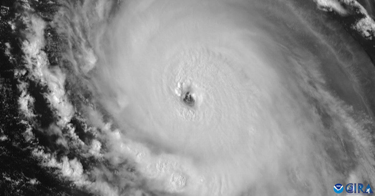
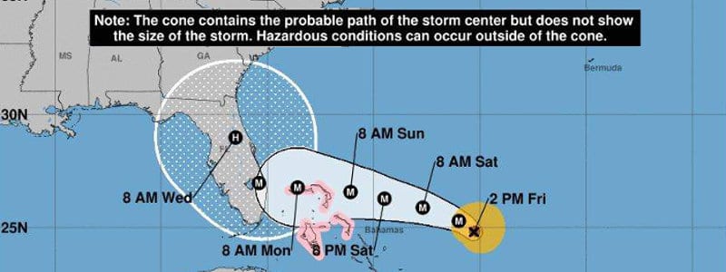
Hurricane Lee became a category 5 hurricane on September 7, 2023—the 4th most rapid intensification on record.
NOAA GOES-16 Satellite Image
Probability for La Niña by Season Peak Increases
Extremely Active 2024 Hurricane Season Forecast Update
August 10, 2024: So far this season, we have four named storms including 2 tropical storms (Alberto and Chris) 1 hurricane (Debby), and 1 major hurricane (Beryl). The NHC is monitoring a tropical wave with a 90% chanc of becoming a tropical cyclone in the next seven days.
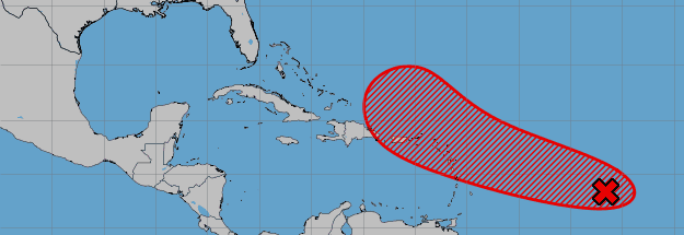
11-August 2024—showers under thunderstorms continue to organize near the Lesser and Greater Antilles with a 90% Chance of development. (NHC)
As of their August 6 forecast update, Colorado State University has increased its estimate for the 2024 hurricane season..
| 2024 Forecast | Average Season | |
| Named Storms | 23 | 14.4 |
| Hurricanes | 12 | 7.2 |
| Major Hurricanes | 6 | 3.2 |
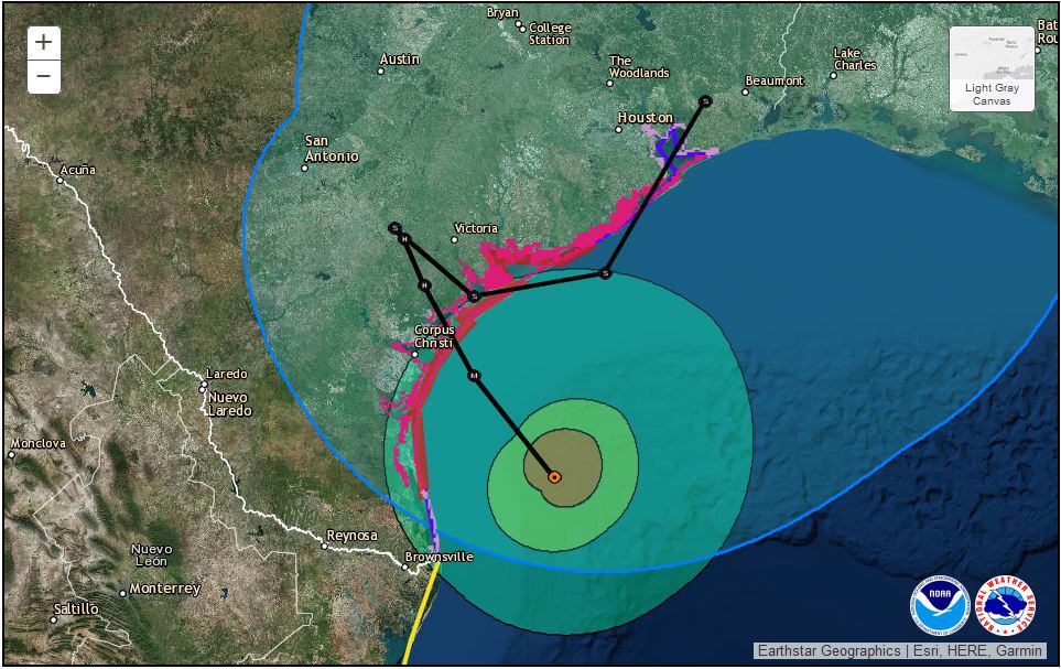
A tropical cyclone organizes as it gains energy from moisture and heat. It first becomes a tropical depression (TD) with winds less than 39 MPH. As it strengthens and the wind reaches or exceeds 39MPH with better organization, it becomes a tropical storm (TD) and is given a name. At 74 MPH, the storm has reached hurricane (H) strength—category 1. It becomes a catetory 2 hurricane at 96 MPH. Sustained winds greater than 110 MPH make the storm a major hurricane (MH) with categories from 3 to 5.
El Niño Ending—La Niña Probable
Next Update: Mid April 2024
April 4, 2024: The state of the El Niño Southern Oscillation (ANSO) has a major impact on weather in North America, the Atlantic Ocean, and around the world. A mild 2023-2024 winter across the north central states is just one example of El Niño’s influence on weather and climate. El Niño will end by June, according to the Climate Prediction Center. Neutral conditions will follow.
An El Niño inhibits tropical cyclone formation and development over the Atlantic Basin. The cooling ocean temperatures along the equator will probably shift to a La Niña by August. High pressure over the Pacific will shift the jet stream north and reduce wind shear over the tropical Atlantic making it easier for tropical cyclones to form.
A shift to La Niña could bring an even more active hurricane season than previous outlooks, forecasts, and predictions.
👀 Special Low Price 👀
La Niña
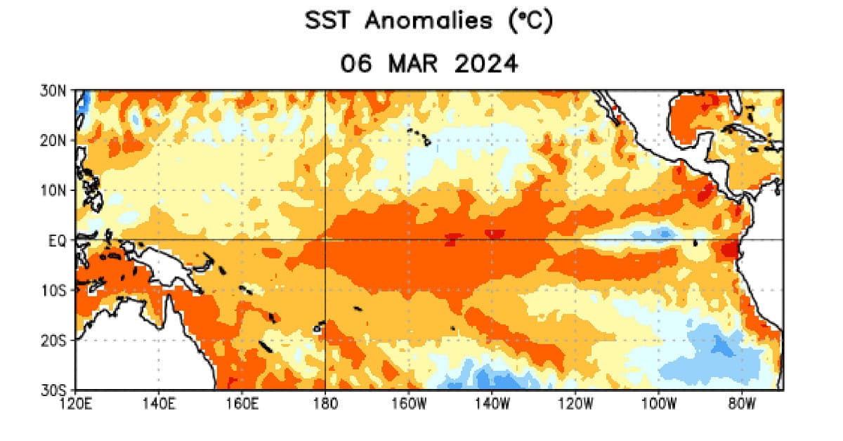
ENSO Neutral conditions continued through July with near-average sea surface temperatures across most of the equatorial Pacific Ocean. (See our ENSO Update article)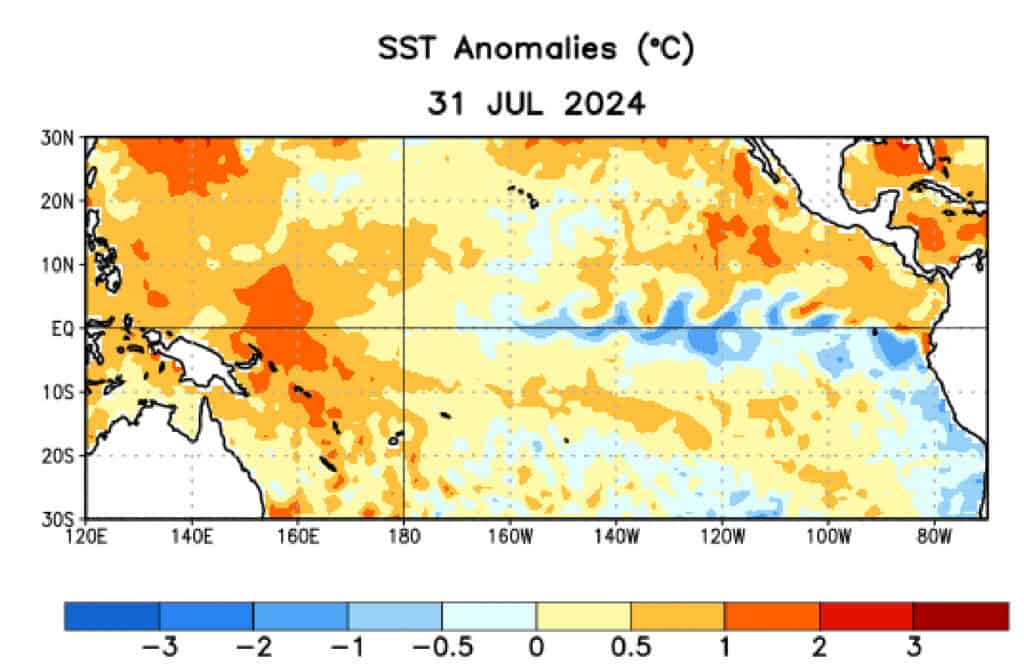
Contrast the above graphic with the one from March (below) and notice the much cooler SSTs along the equator in July. As the ocean water continues to cool, the atmospheric conditions associated with the region will also change. The shift to La Niña will likely happen before October.
La Niña / El Niño events affects weather across North America and the Atlantic Ocean. With respect to Hurricanes, the wind shear across the Atlantic shifts to the north and which supports tropical cyclone development in the tropical Atlantic, Caribbean, and Gulf of Mexico.
The current El Niño is ending as detailed in our ENSO Update article. The orange region along the equator has cooled from about 2 degrees above normal to about 1 degree. Neutral conditions range 0.5 degrees below normal to 0.5 degrees above normal. Below 0.5 degrees, the state of ENSO shifts to La Niña.
February 8, 2024: Long range hurricane season forecasts typically represent the likelihood of an average, below average, or above average season. In the past, Colorado State University’s Department of Tropical Weather & Climate Research would issue a discussion in December about the upcoming season, more than six months ahead of hurricane season. CSU didn’t publish a discussion in December of 2022 or in December 2023, preferring to wait until their first forecast in early April.
Remember—It only takes one hurricane or tropical storm to make landfall near you to turn your season into an active season. Regardless of long-range forecasts, prepare for the 2024 Atlantic Hurricane Season.
Another organization that provides long-term hurricane risk assessment, Tropical Storm Risk (TSR) expects above average activity for the 2024 Atlantic Hurricane Season. The average season, based on thirty years of data from 1991 through 2020, includes:
- 14 Named Storms (tropical storms and hurricanes)
- 7 Hurricanes
- 3 Major Hurricanes
Although the presence of El Niño eastern Pacific Ocean typically dampens Atlantic tropical cyclone activity, the 2023 Atlantic Hurricane Season had an above average season with 20 named storms, seven hurricanes, and 3 major hurricanes, according to a NOAA news release.
A fading El Niño would typically indicate an increase in the number of named storms and coupled with warm sea surface temperatures in the Atlantic, it appears likely for the Atlantic Hurricane Season tropical cyclone activity to match or exceed 2023 activity. In fact, TSR’s Outlook includes 20 storms, 9 hurricanes, and 4 intense hurricanes.
Consider that the Hurricane Season runs for six months from June 1 through November 30. At this point in time (the first week of February) the season start is nearly 4 months away and the season end is nearly 10 months away. A forecast of any kind this far in advance has a wide margin of error due to large uncertainties.
NOAA increases chances for #LaNina for peak of the Atlantic #hurricane season (August-October) from 64% to 74%. Odds of #ElNino have decreased from 6% to 2%. La Nina tends to increase Atlantic hurricane activity via decreases in vertical wind shear, while El Nino increases shear. pic.twitter.com/zrrG4hQeM0
— Philip Klotzbach (@philklotzbach) February 8, 2024
ECMWF forecast for March-May calls for below-normal pressure in subtropical northeast Atlantic. That would result in weaker trades across tropical Atlantic, reinforcing current warmer-than-normal sea surface temps. CSU's first seasonal #hurricane forecast comes out on 4 April. pic.twitter.com/7AHU7nrfc8
— Philip Klotzbach (@philklotzbach) February 5, 2024
Expect an Above Average Hurricane Season in 2024
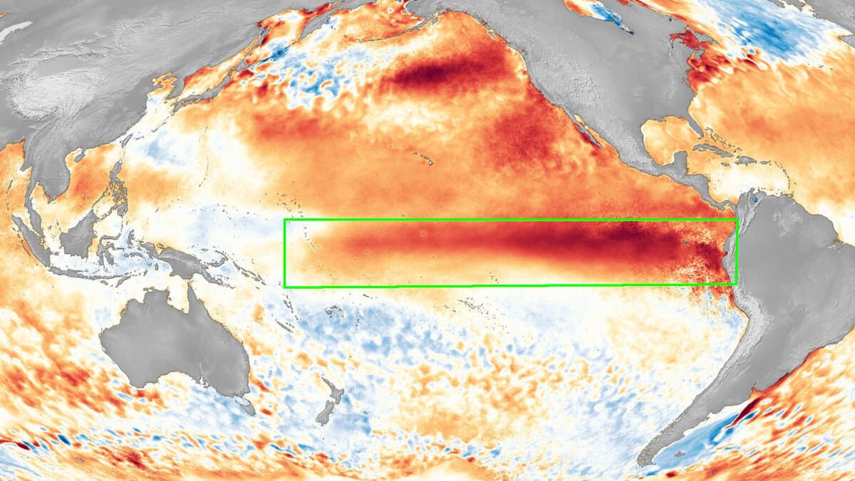
The El Niño Southern Oscillation (shown inside the green box) affects global weather and climate. Currently, the The El Niño state is weakening and the cooler, La Niña state should arrive by the Atlantic Hurricane Season Peak. (NOAA Graphic)
Hurricane Season forecasts never rely on a single indicator. Predictions for the state of the El Niño Southern Oscillation (ENSO) add considerable weight to the forecast models.
El Niño is warmer than average sea surface temperatures in the Pacific Ocean along the equator near North America. La Niña is cooler than average temperatures for the same region. The pattern shifts back and forth every two to seven years. Changes have a predictable effect on ocean temperatures, weather, and the wind and rainfall in the tropics. The shifting ENSO cycle has predictable global side effects. El Niño increases wind shear over the Atlantic region responsible for most cyclone development, which reduces the chances for tropical cyclone formation. La Niña reduces wind shear which aids tropical cyclone development. The current El Niño is fading fast and by the hurricane season peak, the NOAA predicts just a 2% chance the El Niño will persist, and a 55% chance that La Niña will develop.
The end of La Niña gave hope for a quieter, less violent hurricane season, but warmer sea surface temperatures coupled with the warm AMO cycle led to the 4th most active season in history. The return of La Niña in 2024 with warm SSTs and AMO cycle could result in another record breaking Atlantic Hurricane Season. Start Hurricane Preparedness Now. Know Your Risks and Make Your Plans
Sea Surface Temperatures (SSTs) are another factor. Warm SSTs contribute energy from the ocean to cyclone development and can increase the strength and intensity of tropical depressions, tropical storms, and hurricanes. Although the current El Niño was present in 2023, the above average season activity was attributed at least in part to the warm Sea Surface Temperatures. The NOAA expects SSTs to remain above normal, increasing the chance for cyclone development and an above average season.
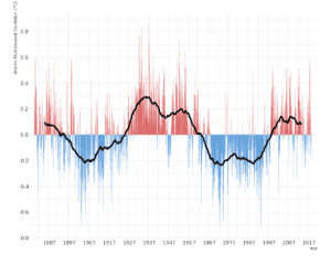
Image by Giorgiogp2
The Atlantic Multidecadal Oscillation (AMO) is a long pattern of atmospheric variability. The AMO has a 50-to-80-year cycle. It affects rainfall over North America and Europe and may affect the intensity of North Atlantic Hurricanes. Long range forecasting of the AMO is difficult for a period as short as three months. The current AMO state is one of warming. However, as shown by the accompanying graph, warm seasons intersperse with the cooler cycles, and cooler seasons may take place during the warmer cycles as a natural part the Atlantic Multidecadal Oscillation.
Seasonal departures within the cycles make predicting the AMO difficult. A warm season contributes to hurricane development, while a cold season dampens cyclone formation. However, given the current warm cycle, the AMO will likely contribute to tropical cyclone formation.
The 2024 Atlantic Hurricane Season Outlook
Long-range forecasts are at best uncertain. Outlook is a better way to look at the upcoming season. As this is only February, we should expect the outlook to change as we move closer to the start of the hurricane season on June 1. Tropical cyclones can form at any time of year, in any month, and impact the United States and other countries.
Storms |
2024 Outlook |
Average Year |
| Named Storms | 18-22 | 14.4 |
| Hurricanes | 9-10 | 7.2 |
| Major Hurricanes | 3-5 | 3.2 |
Any hurricane season, regardless of the projected activity, could bring a disaster anywhere along the East Coast or Gulf Coast.
Hurricane Preparedness Steps to Take Now
- Hurricane Prep takes planning and time. Don’t wait. Start now.
- Understand Hurricane Risks Posed by Water & Wind
- Hurricane Pre-Season Prep
- Understand Hurricane Forecasts & Where to Get Them.
- Know What to Do When a Storm Threatens
- Stay Protected During Storms. Prepare Your Safe Place.
- Be Careful After Storms. Many Hazards Remain.
Hurricane Season Preparedness Resources

2024 Atlantic Hurricane Season Names
- TS Alberto – June 19
- MH Beryl – June 28
- TS Chris – June 30
- H Debby – August 2
- Ernesto
- Francine
- Gordon
- Helene
- Isaac
- Joyce
- Kirk
- Leslie
- Milton
- Nadine
- Oscar
- Patty
- Rafael
- Sara
- Tony
- Valerie
- William
Prior to the record-setting 2020 hurricane season, after using all the names on the list for that year, additional names were chosen from the Greek Alphabet. The only two years the NHC employed Greek letter naming convention were 2005 and 2020.
After the 2020 season, an auxilliary list of storm names provides additional storm names for years with more than 21 names.
The 202o season broke many records. There were 31 tropical cyclones, of which 30 became named storms, 14 became hurricanes, and 7 strengthened into major hurricanes.

