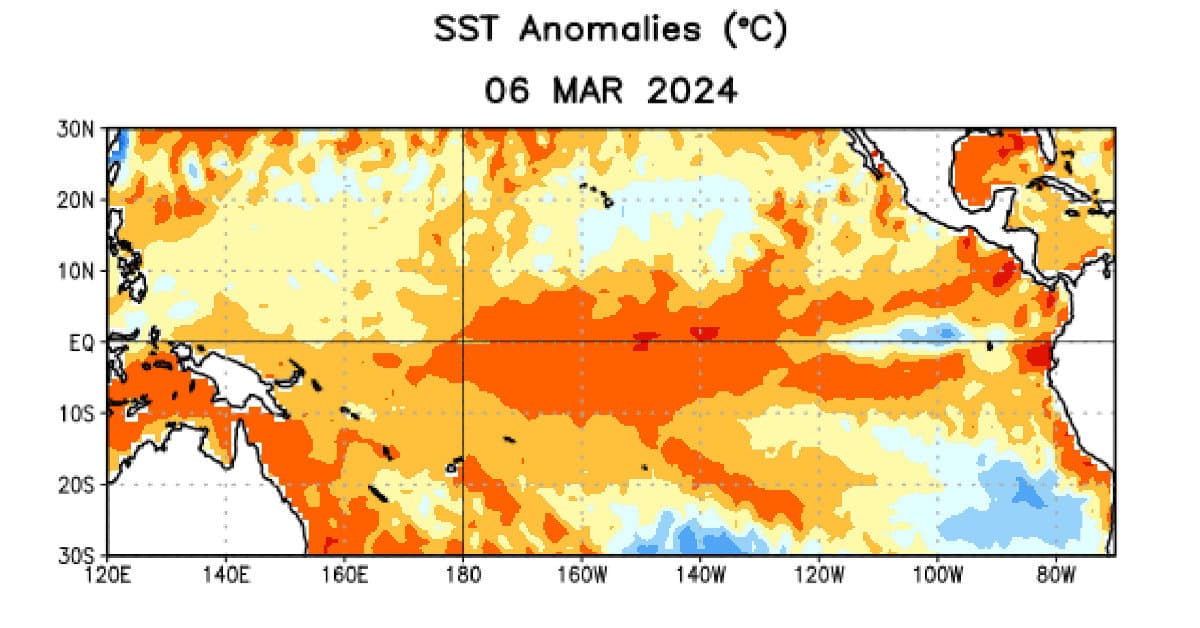
Sea Surface Temperature Anomalies for the Eastern Equatorial Pacific Ocean About 1 Degree C (orange-read) Above Normal
El Niño to End by June—La Niña Likely by August
The NOAA’s Climate Prediction Center has issued an El Niño advisory and a La Niña watch. As of March 14, 2024, El Niño will end (83% chance) by April-June and odds favor the development of La Niña with 62% chance by June and 82% chance by August.
2024 Atlantic Hurricane Season Forecast Updates Predictions
A La Niña promotes Tropical Cyclone Development in the North Atlantic Basin. Numerous factors influence the Atlantic Hurricane Season including SSTs and the AMO, among other factors. Although 2023 was an El Niño year, the Atlantic Basin was still active with more than the average number of hurricanes. As El Niño fades to Neutral before shifting to La Niña, forecasters expect active and above average tropical cyclone development.
The El Niño Southern Oscillation (ENSO) is a weather pattern over the far eastern tropical Pacific Ocean with global weather effects on a large scale.
ENSO oscillates between El Niño, Neutral, and La Niña.
Historically, a La Nina follows strong El Niño events like the one currently in the stages of decline. Warm water temperatures over eastern equatorial Pacific began a decline from +2° C in December to about +1.75 °C in January. Model predictions made in February show a steady decline in Sea Surface Temperatures (SSTs) from El Niño to Neutral in the April-May-June time frame and La Niña conditions as early as June.
As of March 6, 2024, the SST anomalies for the ENSO region of the Pacific Ocean were close to 1 degree above normal, down almost an entire degree from January and with one small cooler than normal area near Central America.

El Niño
An El Niño takes place when the eastern Pacific Ocean temperatures along the equator rise as much as 2 degrees over their historic norm. The winter of 2023/2024 was an El Niño winter with much warmer weather than usual for Canada and the northern half of the United States. These same regions had very little snow compared to most years and the lower Greater Lakes was much drier than usual.
During an El Niño year, a Pacific Jet stream amplifies the winter storm tracks across the southern USA and northern Mexico bringing wetter weather in the west and colder, wetter weather from Texas to Florida, Georgia, and South Carolina.
Some people look upon warmer weather as a blessing, while others wish for the snow and cold that brings tourists and winter weather activities like skiing and snowboarding or ice fishing.
Perhaps one of most important upsides to an El Niño year happens over the Atlantic Ocean. The same jet stream that brings storms across the southern USA also imposes wind shear over the Atlantic which in turn dampens cyclone formation. The 2023 Hurricane Season was an active year despite the ongoing El Niño with other factors encouraging tropical cyclone formation.
The Walker Circulation is a mechanism that regulates momentum, heat, and water vapor in a regular, cyclic pattern along the tropics across the entire globe. During El Niño, the Walker Circulation affecting the Pacific Ocean, United States, and Atlantic Ocean has a sinking column of air over Indonesia that flows east near the surface and picks up heat and moisture from the warm Pacific Ocean. As it reaches the West Coast, the warm, moist air rises and splits. Some flows west and returns to the sinking column over Indonesia. The rest flows east and sinks over the tropical Atlantic where it splits again. The air flowing east over the Atlantic contributes to reduced cyclone activity.
Persistent low pressure over the central and eastern Pacific Ocean typifies an El Niño.

During El Niño, the Walker Circulation feeds a rising column of air over the eastern equatorial Pacific (the ENSO region) from the eastern and western portions of the circulation. the column of air splits to flow east and west, and sinks over Pacific Asia and the Tropical Atlantic. The sinking columns of air split and flow east and west. The eastern flow over the Atlantic inhibits Atlantic Tropical Cyclone formation. NOAA Climate Prediction Center Graphic.
Neutral
The transition from an El Niño to La Niña takes place over months. The Eastern Pacific Ocean along the equator cools to within 0.5 degrees Celsius of normal and the low pressure over the Eastern Pacific Ocean dissipates as higher pressure pushes it out. The Pacific Jet Stream begins a shift north and takes the wet weather with it. A neutral ENSO state has less impact on the Atlantic Hurricane Season. Neutral conditions contribute to a change in the Walker Circulation—warm moist air rises over Indonesia and over the tropical Atlantic (where it can contribute to cyclone formation). There is less shear from east to west over the central tropical Atlantic.

When ENSO conditions are Neutral (SSTs are normal) The Walker Circulation changes with rising columns of warm, moist air over the Tropical Atlantic and the Asian Pacific. Significant is the western air flow off of Africa which, unlike the El Niño eastern flow, does not inhibit tropical cyclone formation. NOAA Climate Prediction Center Graphic
La Niña
Cooler tropical Pacific Ocean temperatures along the equator, in the range of -0.5 C to -2.0 C typify a La Niña. High pressure over the Pacific Ocean keeps the jet stream to the north along the Alaskan and Canadian coasts. It then plunges into the midsection of the USA before turning north through New England and exiting the continent over the Canadian Atlantic Provinces.
It brings colder air to much of the northern part of the country and wetter conditions to the lower Great Lakes and northern West Coast. Below the jet stream it is warmer and drier from the West Coast to East Coast.
With the jet stream headed north along the East Coast, wind shear over the Atlantic drops. Lack of wind shear with an increase in the westerly trade winds along the tropical Atlantic make conditions more conducive to tropical cyclone formation.
The Walker Circulation Shifts to a strong column of rising warm, moist air over Indonesia, the tropical Atlantic, and the Caribbean. This enhances flow from Africa and the contribution of warm, moist air conducive to tropical cyclone formation.

The cool ENSO region creates atmospheric high pressure, which pushes the Pacific Jet Stream North. Strong easterly flow off Africa contributes to the column of rising moist air over the Tropical Atlantic. Reduced wind shear because the Pacific Jet Stream along with the stronger easterly flow of warm, moist from Africa promotes tropical cyclone formation. NOAA Climate Prediction Center Graphic


