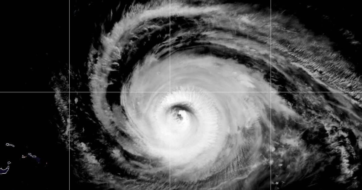
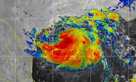
Major Hurricane Lee approximately 400 miles north of Puerto Rico on September 11, 2023, one day after the historical season peak. Lee’s track has become more certain and will likey hit the New England coast or Novia Scotia. NOAA Satellite Imagery.
Posted February 15, 2023 | News & Updates | Tropical Cyclone
2023 Hurricane Season | Hurricane Preparedness | Hurricane Season | Forecast
Updated September 11, 2023
by MJ Logan


Before and After Hurricane Ian-Images of the Fort Myers Pier, Fort Myers, Florida. September, 2022.
2023 Hurricane Season Peak Update and Forecast
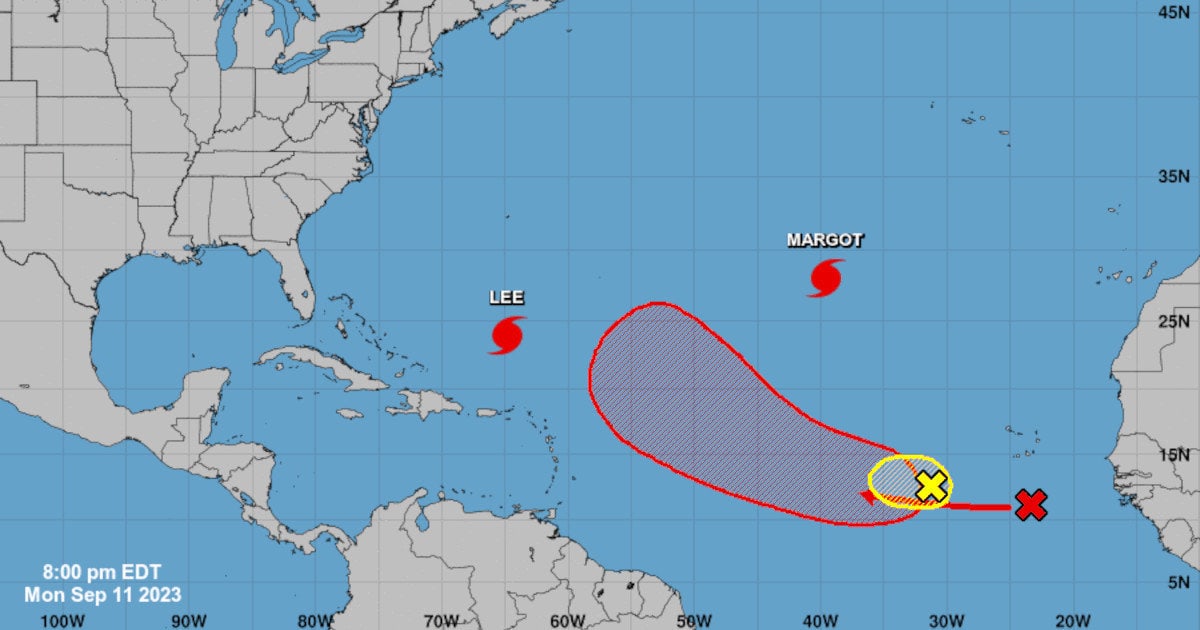
Where Will Hurricane Lee Hit?
At the historical peak of the 2023 Atlantic Hurricane Season, the Atlantic basin had already produced 14 storms, more than the original estimates prior to the season. So far, the seaon has generated nine tropical storms and five hurricanes, including two major hurricanes.
Hurricane Lee
Category 3 Hurricane Lee is headed for the Northeast and will impact the coast between Rhode Island and Novia Scotia. After rapid intesification to a category five storm with sustained winds of 155 MPH, Lee gave up some of its strength as it passed through an environment of dry air. Lee will likely lose more strength over the next week ahead of landfall
Dangerous Rip Currents and Heavy Surf are expected along the East Coast, Caribbean, and Bermuda throughout the week.
Hurricane Margot
Hurricane Margot is over the central Atlantic and is unlikely to threaten land. Margo is a Category 1 storm on northward track that won’t take it anywhere near land over the next seven days. Presently with 75 MPH sustained winds, Margot will strengthen over the next few days to Category 2 with 100 MPH winds.
Behind and to the south of Margo, another system has a 70 percent chance of development. The long term forecast for this storm is unknown, but the NHC will likely name it “Vince” once it reaches tropical storm strength.
NHC 7-Day Tropical Weather Outlook for the Atlantic Basin
In January, a system initially dismissed as unlikely to organize was reassessed in May by the National Hurricane Center. The Sub-tropical storm did not receive a name because it was not recognized until Mid-May. It brought snow to New England and 68 MPH gusts to Novia Scotia. A sub-tropical storm has both tropical and extra-tropical characteristics—it takes energy from the ocean and stable temperature gradients in the atomosphere.
–End Season Peak Update
This is an early outlook for the upcoming Atlantic Hurricane Season which starts on June 1, 2023 and runs through November 30, 2023. The six-month long season reaches a peak in September. The start, end, and peak season dates are based on historical data.


Before and After Hurricane Ian Neighborhood Homes
Update April 13, 2023.
“As is the case with all hurricane seasons, coastal residents are reminded that it only takes one hurricane making landfall to make it an active season for them. They should prepare the same for every season, regardless of how much activity is predicted.” ~CSU
The Colorado State University Tropical Meteorology Department released its first forecast for the 2023 Atlantic Hurricane Season on April 13, 2023 at 10 AM EDT. In the Eastern Pacific Ocean along the equator, the cooler La Niña conditions have shifted to neutral and are likely to remain neutral through the summer months which may mean less tropical activity. However, the El Niño Southern Oscillation (ENSO) is only one factor that determines Atlantic Cyclone Activity. The Atlantic Multi-decadal Oscillation is another, along with tropical ocean Surface Sea Temperatures (SSTs). As we saw for over a month in the record-setting 2020 season, high levels of dust in the air from the Sahara Desert can stifle tropical activity.
Early forecasts and discussions by all agencies and organizations for the 2020 hurricane season underestimated activity by a wide margin. The season ended with a record 30 named storms and 31 cyclones. It forced the retirement of the Greek Alphabet as a naming system used when the number of storms exceeded the number of previously picked storm names.
#Ian's tropical cyclone report by the National #Hurricane Center has been released:https://t.co/Kn3SwaPLcd
— Philip Klotzbach (@philklotzbach) April 3, 2023
Upgraded to a Cat. 5 hurricane (140 kt winds) in southeastern Gulf of Mexico but remains a Cat. 4 at landfall. 130 kt Cayo Costa landfall & 125 kt Punta Gorda landfall. pic.twitter.com/xLrRcDXzGW
| Forecast | CSU 2023 Forecast | 30-Year Average 1991-2020 |
| Named Storms | 13 | 14.4 |
| Hurricanes | 6 | 7.2 |
| Major Hurricanes | 2 | 3.2 |
| Accumulated Cyclone Energy | 100 | 123 |
According to CSU, the 2022 Atlantic Hurricane Season was near average with a slightly lower ACE than average.
The most significant storm was Hurricane Ian which devastaged the Fort Meyers area and flood large areas of the state. Analysis indicates that Ian was a Category 5 storm before it made landfall as a Category 4 storm.
Colorado State University Tropical Weather and Climate Research issued a slightly lower than average activity forecast in the Atlantic Basin. The shift of the El Niño Southern Oscillation (ENSO) from La Niña to Neutral set expectations for a lower than average forecast. Now forecaster are looking at the possibility that the Neutral ENSO state may shift to a weak El Niño late this summer or fall.
“Larger-than-normal uncertainty exists with this outlook. We anticipate a near-average probability for major hurricanes making landfall along the continental United States coastline and in the Caribbean.” ~CSU
As stated previously, ENSO is just one factor that affects the number of cyclones in the Atlantic Ocean, Caribbean, and Gulf of Mexico. Warmer than usual sea surface temperatures could allow for a busy Atlantic Hurricane Season if strong El Niño does not develop.
If you live along the coast, prepare for hurricanes and tropical storms. The season is just 1 1/2 months away.
/Update
Early outlooks are an assessment of current conditions and expected changes in the weather that affect the hurricane season. Factors that affect the season but are difficult to forecast can change the season for more or fewer storms. In 2020, a persistent dust cloud from the Sahara Desert over the Atlantic Ocean suppressed activity for over a month.
Other factors are subject to change. The current state of the El Nino Southern Oscillation (ENSO) is one factor that is currently tilting in favor of a less intense season. However, the Atlantic Multidecadal Oscillation remains in a warm phase, which promotes tropical weather development.
Last year, the 2022 Atlantic Hurricane Season finished as a near-average after predictions of an above average season leading up to the season start and through September.
Norwall joins FEMA and the NWS in reminding everyone that it only takes one hurricane to landfall near your home to make your season, an active season.
Latest NOAA ENSO forecast gives a 60% chance of #ElNino for the peak of the Atlantic #hurricane season (August-October). El Nino typically reduces Atlantic hurricane activity via increases in vertical wind shear. Too much shear tears apart hurricanes. pic.twitter.com/DNHVuC1ejg
— Philip Klotzbach (@philklotzbach) February 9, 2023
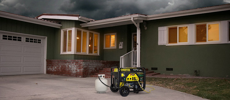
Now at Norwall, the most powerful Generac Guardian 26kW is on sale now for a limited time. This Smart Grid Ready generator handles large homes and multiple air conditioners.
— Norwall PowerSystems (@NorwallPowerSys) March 2, 2023
Learn More at Norwallhttps://t.co/7svLzDQFUA pic.twitter.com/lx0GMDoY8j
🌧️🌪️🌬️ If severe weather is in the forecast, which backup power source would you prefer?#BackupPower #SevereWeather #polls
— Norwall PowerSystems (@NorwallPowerSys) April 11, 2023

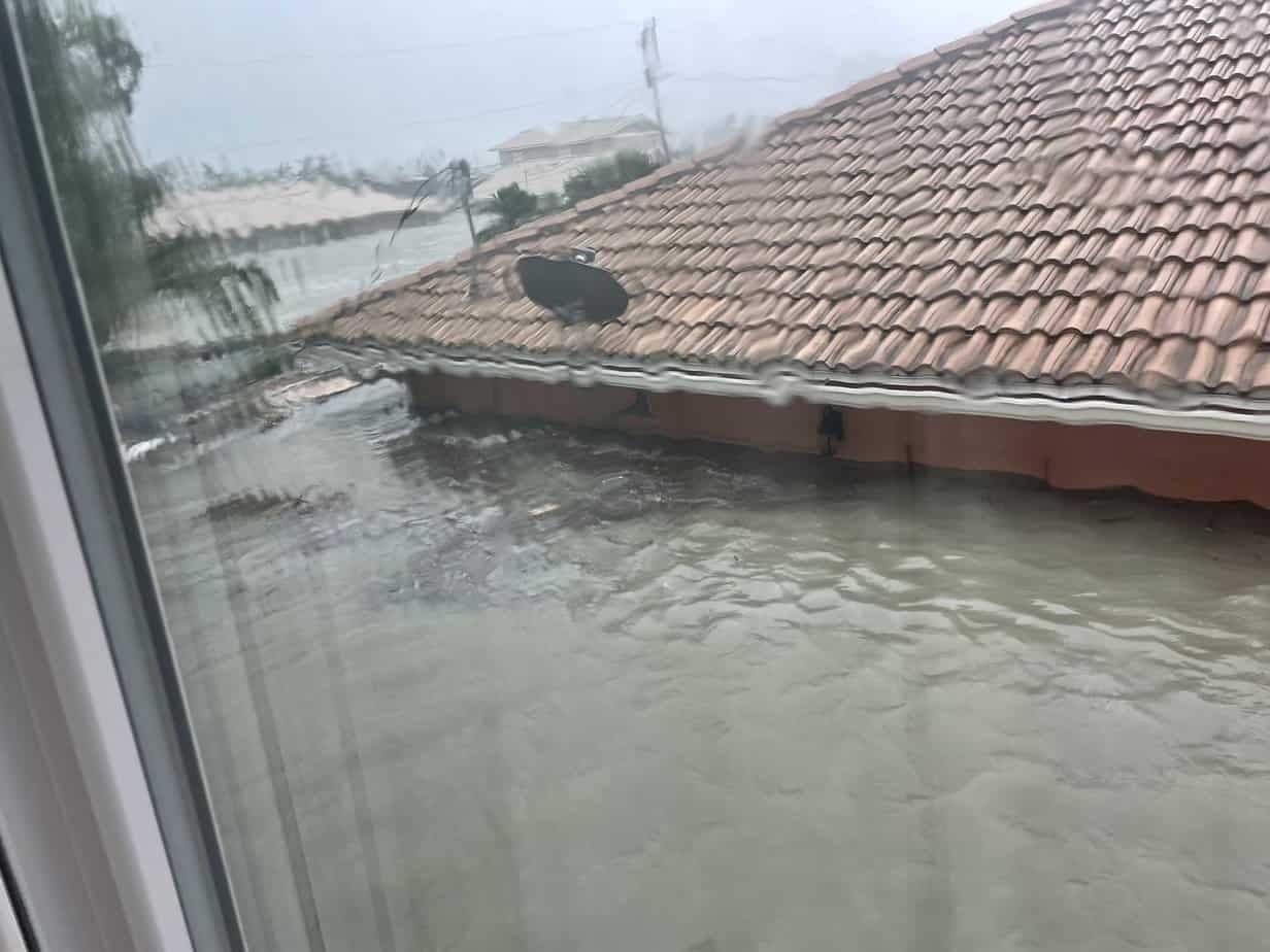
The Storm Surge Swept Inland with Surprising Speed in Naples, Florida. Note the fast-moving water and the depth as the water rises around buildings. In the second photo, a home is almost completely submerged by storm surge flooding.
2023 Hurricanes and Tropical Storms

The dust cloud over the Tropical Atlantic Ocean (gray area—lower right to upper left) is clearly visible in this satellite image from the NOAA in the summer of 2020. Dust from the Sarhara is an annual event, but the extensive size and area it covered dampened tropical development for more than a month. In spite of the dust cloud, the 2020 hurricane season turned hyperactive with 31 tropical cyclones, 30 named storms, 14 hurricanes and 7 major hurricanes—the most active season on record.
The El Nino Southern Oscillation appears ready to swing toward the El Nino phase. Over the summer, the chance of a shift to El Nio has increased to 60 percent, according to the NOAA. The south-eastern Pacific Ocean surface temperatures affect Atlantic Ocean tropical weather systems. El Nino conditions are warmer ocean temperatures while La Nina indicates cooler ocean temperatures near the equator west of the Americas.
This is not the first time that NOAA has predicted a shift toward El Nino. Following the record-breaking 2020 Atlantic Hurricane Season, forecasters predicted a shift in 2021 and in 2022. ENSO remained in a cool La Nina state which promotes more hurricanes in the Atlantic.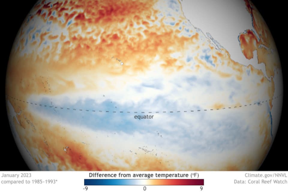
The area in blue indicates the lower surface sea temperatures associated with the La Nina phase of the eastern Pacific Ocean. La Nina affects weather systems in North America and the Atlantic Ocean and aids tropcial cyclone formation.
Since the 1990s, the Atlantic Multidecadal Oscillation has stayed in a warm phase. Warmer ocean waters help storm development. The oscillation between cool and warm takes place over a twenty to forty years. The temperature difference is slight—less than one degree between extremes. It affects the entire Atlantic Basin north of the equator and possibly parts of the Pacific Ocean as well.
Ocean temperatures typically reach a peak around September-October, coinciding with peak tropical cyclone activity. They reach a low around March and April.
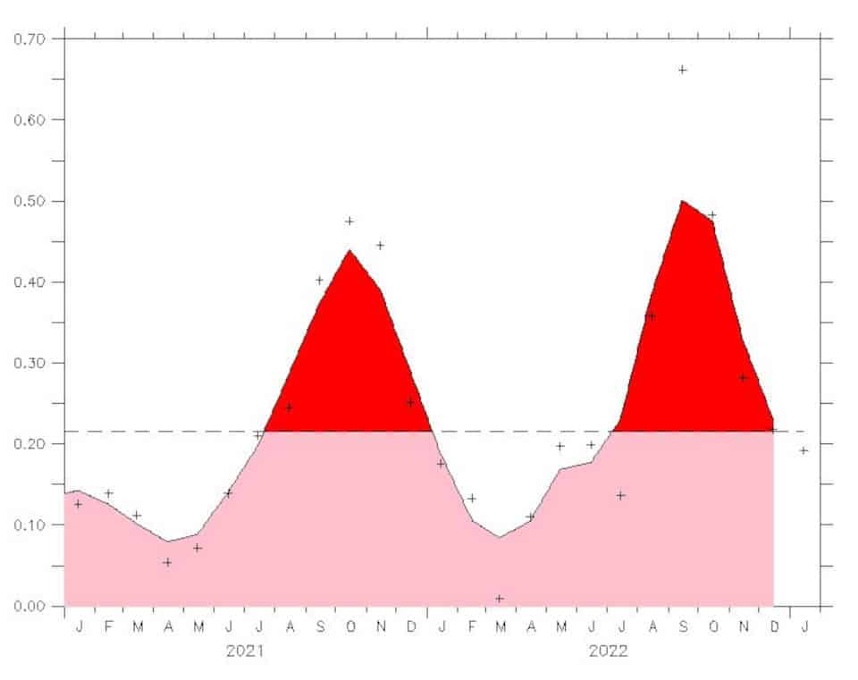
The Atlantic Multidecadal Oscillation or AMO is a long ocean temperature that affects tropical cyclone development. The current state is a warm phase. Using tree rings and ice cores, the AMO has swung less than 1 degree over the past 1000 years and probably longer—long before modern man began affecting climate.
With two of the better-known factors for determining the hurricane season outlook in opposition, the season intensity is an educated guess. The outlook presented by Tropical Storm Risk (TSR) in December indicates a below-average to average season.
If the El Nino Southern Oscillation remains in a cooler, La Nina phase (40 percent chance), we could have a more active season.
Hurricane Season Records and Outlook
| Named Storms | Hurricanes | Major Hurricanes | |
| Average (1991-2020 | 14.4 | 7.2 | 3.2 |
| Record High (2020) | 30 | 15 | 7 |
| Record Low | 4 | 2 | 0 |
| TSR’s 2023 Prediction1 | 13 | 6 | 3 |
1 As of December 6, 2022.

Fort Meyers, Florida. Storm surge waters reach the eaves on a house and other houses and buildings in the background.
Hurricane Preparedness Resources
Hurricane Preparedness
- Hurricane Hazards and Risk Factors
- Make a Hurricane Evacuation Plan
- Hurricane Preparedness Kits and Supplies
- Hurricane Insurance Checkup and Updates
- Prepare Your Home for Hurricanes
- Help Neighbors with Hurricane Preparedness
- Complete Your Hurricane Preparedness Plan
- Emergency Preparedness Tips
- How to Prepare for a Power Outage
- 10 Tips to Survive a Hurricane Disaster
- FEMA Recommends a Generator
- Hurricane Disaster Preparedness

Most Powerful Home Generator Available—Briggs & Stratton 26kW Generator with Automatic Transfer Switch.
Nevertheless, significant non-tropical development of the low is expected during the next couple of days, and hurricane-force wind warnings are in effect. Refer to High Seas Forecasts from @NHC_TAFB and @NWSOPC for more info.https://t.co/qzKXRzpvYK
— National Hurricane Center (@NHC_Atlantic) December 8, 2022
Did you know that a standby generator is built to run in any weather, including a hurricane? When an outage hits, they start in seconds and run until the utility restores power.


