Widespread Evacuations Ordered for Coastal Residents in Hurricane Harvey’s Path – Updated 6:00 PM CDT
From the National Hurricane Center office in Miami, Florida, 2:00 PM EDT, 8-24-2017.
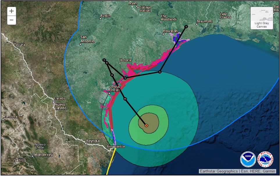
Update 6:00 PM CDT 8-27-2017
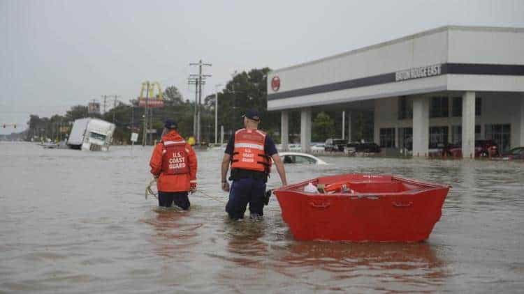
The National Hurricane Center is calling Harvey an unprecedented event which is still unfolding after making landfall Friday evening. The rain continues to fall and Harvey remains a tropical storm over Texas. Rainfall estimates for the event will top 50 inches in some areas. The flooding in Houston and other areas is catastrophic.
Residents are urged to only use 911 if their life is in danger. Responders and call centers are overwhelmed.
If your home is flooded, use the roof. Do not enter the attic unless you have an ax or other means to open a hole for escape. Flood waters continue to rise along with injuries and fatalities.
Rescue Pilots are reporting dangerous encounters with drones flying over flood areas and the small, remote controlled aircraft are hampering efforts.
Twitter…
The FAA is pleading with people not to fly drones over #harvey aftermath. Military and state first responders reporting drone sightings https://t.co/5lcPYJpYDr
— Kris Van Cleave (@krisvancleave) August 27, 2017
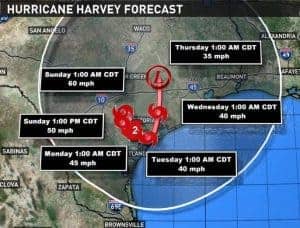
Harvey will move offshore on Monday where it may strengthen somewhat, then come ashore again within 72 hours and cross Texas and Louisiana into Arkansas as a Tropical Depression. Rain and wind are expected in a wide swath that covers a third of Oklahoma, all of Louisiana, Arkansas, portions of Mississippi, and the eastern third of Texas.
The forecast models currently show Harvey remaining a tropical storm for three days and tropical depression through days four and five as it heads northeast through Arkansas.
Update 2:00 PM CDT 8-26-2017
Harvey has weakened and the NHC has downgraded it to a strong tropical storm with 70 MPH winds after making landfall last night as a major hurricane. Significant hazards remain in the form of storm surge, flooding, and heavy rainfall. Over the next five days, some areas will receive total rainfalls as high as 40 inches.
Texas and Louisiana authorities report nearly 350,000 electric utility customers are without power.
What will my Portable Generator Run?
A portion of Harvey’s circulation remains over water which will slow weakening as the cyclone moves at just 2 MPH and contribute to the heavy rain that some areas are still receiving. NHC models agree—the storm will meander over southeast Texas as a tropical storm for the next 24 to 36 hours, then a tropical depression for at least 4 to 7 days.
Flood waters are a significant risk. Do not drive into water. Stay out of areas deemed unsafe by authorities. Heed all warnings and advisories. If you evacuated, do not attempt to return until authorities give the okay.
Update 6:00 PM CDT 8-25-2017
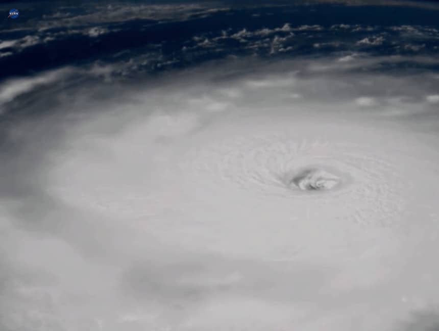
Major Hurricane Harvey, now a category 4 storm, poses a catastrophic risk to life and property and may strengthen further in the next few hours. Harvey will make landfall this evening as a category 4 hurricane. Unlike other tropical cyclones that move ashore and weaken quickly, Harvey is likely to stall or move very slowly along the coast with a significant portion of the circulation remaining over water, further increasing rainfall amounts.
A large portion of the Texas coast will received rainfall amounts exceeding 20 inches. Further east significant portions of Louisiana will receive more than 10 inches of rain. As noted earlier, local amounts could reach three feet over the next few days. The NHC continues to refine its forecast and further updates will be posted as appropriate.
If you are in the path of the storm and have not evacuated, the window of opportunity to reach safety is rapidly closing.
Update 12:00 PM CDT 8-25-2017
“A Grave Risk to the folks of Texas” says Louis Uccellinim, head of the National Weather Service. Hurricane Harvey, now a Category 2 Hurricane with 110 MPH sustained winds and 130 MPH gusts is expected to strengthen to Category 3 in the next few hours, according to the National Weather Service. Storm surge predictions are still at 6-12 feet, with up to three feet of rain predicted over the next 5-6 days.
The NHC warns that even if winds do not increase significantly, the worst risks to life and property come from storm surge and flooding. Harvey will likely stall or meander near the coast and slowly lose intensity, remaining a hurricane and tropical storm through the next 5 to 6 days.
—
Hurricane Harvey, upgraded from a tropical storm to a hurricane, will continue strengthen over warm Gulf waters in an environment rich for tropical cyclone development. Harvey is expected to become at least a Category 3 storm by the time it makes landfall on the Texas Coast. A category 3 hurricane has winds as high as 130 MPH. Harvey’s winds will reach approximately 120 MPH.
A Hurricane Warning is in effect from Sargant Texas to Port Mansfield and hurricane watches in effect from Port Mansfield to the Rio Grande River. A warning means that hurricane conditions are expected within the warning area within 36 hours. A watch is issued 48 hours ahead of expected hurricane conditions.
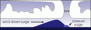
More dangerous than the wind is the life-threatening storm surge from 6 to 12 feet above the normal tide. Along with the surge, inland flooding will occur as Harvey drops up to 25 inches of rain. Storm surge is the leading cause of fatalities and the most dangerous hazard of tropical cyclones. The high winds and low pressure combine to build a mound of water that pushes inland and quickly inundates the coast with rapidly rising flood waters.
Learn More About Hurricanes and How to Prepare for Them
Residents should heed evacuation orders and follow their designated evacuation routes before storm conditions arrive. Once the hurricane begins to reach inland, travel will become difficult or impossible.
If you are under evacuation orders, secure your home and take your family and pets to safety.
Must Know Information
Harvey is expected to become a Major Hurricane of at least category three sometime on Friday, August 25. It will bring life-threatening storm surge, dangerous winds, and inland flooding. It is likely to spawn tornadoes that will cause further damage and endanger lives. Complete preparations to secure property by this evening, August 24.
The storm surge of 6 to 12 feet will threaten lives and property, and is the most dangerous aspect of the storm. If you live along the coast in a storm surge warning area, follow evacuation orders and leave.
Devastating flooding is expected with rainfall totals from 15 to 25 inches, and up to 35 inches in some areas. The worst of the rain will occur from Friday through Wednesday, August 30.
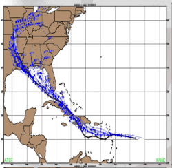
Check the Potential Storm Surge Flooding Map to determine your risk of storm surge and act accordingly. Surges of 6 to 12 feet are expected along waterways up to 30 miles inland from the barrier islands.
Harvey to Meander along Coast
Once inland, Harvey will shift coarse from the N-NW track and meander inland along the coast, first as a hurricane, then a tropical storm. How quickly it loses strength will depend on how far inland it travels before it stalls against a high-pressure system. It will then follow and uncertain path that may take it back out over the gulf where the potential exists for it to strengthen again.
Forecast models are uncertain where Harvey’s track will take it after making landfall. Texas coastal residents can expect tropical storm conditions through at least Tuesday or Wednesday, August 30.
Last Minute Preparations

If you are not under evacuation orders and far enough inland to avoid the storm surge, you still have a short window of time to prepare.
Secure fuel supplies for portable generators. Rotate older fuel by using it in vehicles and refill storage containers with fresh gasoline. Fill ALL vehicles with gasoline ahead of the storm.
Store water containers for drinking and washing. Each person will need a gallon per day for drinking and another gallon per day for personal hygiene. Harvey is expected to affect the Texas Coast for at least a week, so plan accordingly.
Do you have all the medicine you need for at least a week? Refill prescriptions and store medicine in watertight zipper bags. Double bag to keep it usable, even during flood.
FEMA recommends a portable generator for emergencies at a minimum. Remember to stock oil, filters, and spark plugs for maintenance according to the manufacturer’s schedule.
Standby generators run automatically, don’t need refueling, and can keep critical and essential circuits supplied with power. Check the oil daily during extended run times and remember to have the oil and filters changed at the correct intervals.
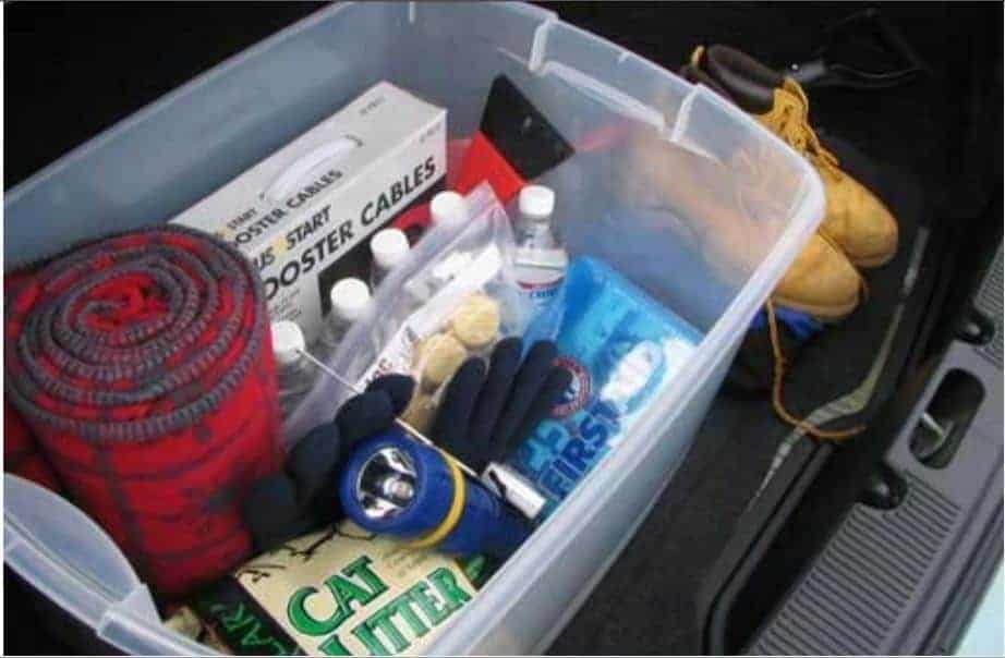
Check your emergency disaster kit and replenish your supplies if necessary including your shelter-in-place supplies.
Don’t forget about your pets. They need food and water and you can’t let them outside during the storm.
Updated 6:00 PM CDT on August 25, 2017
Updated 12:00PM CDT on August 25, 2017


