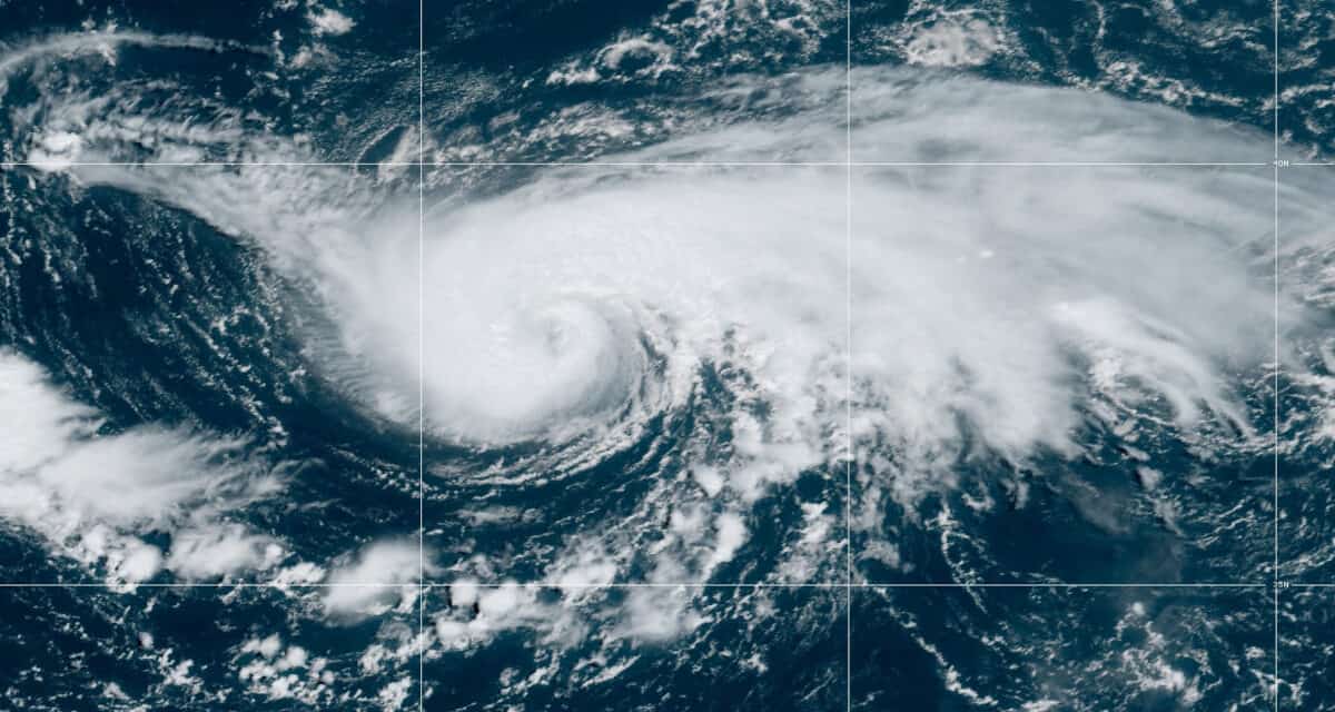
Hurricane Danielle GOES East Satellite Image on September 2, 2022, 885 Miles West of the Azores.
Hurricane Danielle Evolution and Forecast
At 3:00 AM GMT, Tropical Storm Danielle was still strengthening. Satellite imagery revealed the beginnings of an eye and winds of 65 MPH—a very strong tropical storm. By 9:00 AM GMT, Danielle’s intensification continued with winds reaching 70 MPH. Forecaster Beven at the National Hurricane Center noted the intensity was conservative and the wind speeds could have been higher. Danielle continued to strengthen for the next six hours. At the 3:00 PM GMT Discussion, the NHC upgraded the tropical storm to Hurricane Danielle with 75 MPH winds.
2022 Atlantic Hurricane Season Early Forecast & Outlook
Hurricane Danielle is currently meandering slowly to the east about 885 miles west of the Azores. It is a small storm with hurricane-force winds extending 15 miles from the center and tropical storm force winds 115 miles. For the next day or two, it should continue to meander on its present easterly course at one to two miles per hours. Later this weekend, or early next week, the hurricane will make a slow turn to the northeast. As of the last NHC discussion report, Danielle’s motion had stopped, and it was stationary.
Danielle is over warm water, the primary source of energy for a tropical cyclone. It should continue to intensify over the weekend before it begins to move over cooler waters and into a region of wind shear. As the high-pressure ridge blocking the storm dissipates, Danielle will begin moving northeast. As it moves over cooler water, the forward motion will increase.
How to Use a Portable Generator for Home Backup
The hurricane has the potential to become a category 2 storm by mid-afternoon on Sunday. It won’t begin to weaken until Monday or Tuesday. Forecasters expect it to stay a hurricane for at least five days despite moving over cooler water and into a region of wind shear.
Danielle does not pose a direct risk to land at this time, but could impact coastlines with heavy surf and rip currents. The National Hurricane Center has issued no key messages on Hurricane Danielle.
#Danielle is now a #hurricane - the 1st of the 2022 Atlantic #hurricane season. This is the latest calendar year 1st Atlantic hurricane since 2013 (Humberto on 11 September). pic.twitter.com/VcO2CmPJ1H
— Philip Klotzbach (@philklotzbach) September 2, 2022
JUST IN: #Danielle has strengthened into the first hurricane of the 2022 Atlantic season. The storm is located 885 miles west of the Azores and has maximum sustained winds of 75 mph: https://t.co/m6gWshrlSN pic.twitter.com/6uSwvSWwr1
— Breaking Weather by AccuWeather (@breakingweather) September 2, 2022
Did You Know? A home standby generator runs in any weather, including hurricanes, is fully automatic and doesn’t require refueling every few hours? An efficient natural gas generator or propane generator runs your entire home.

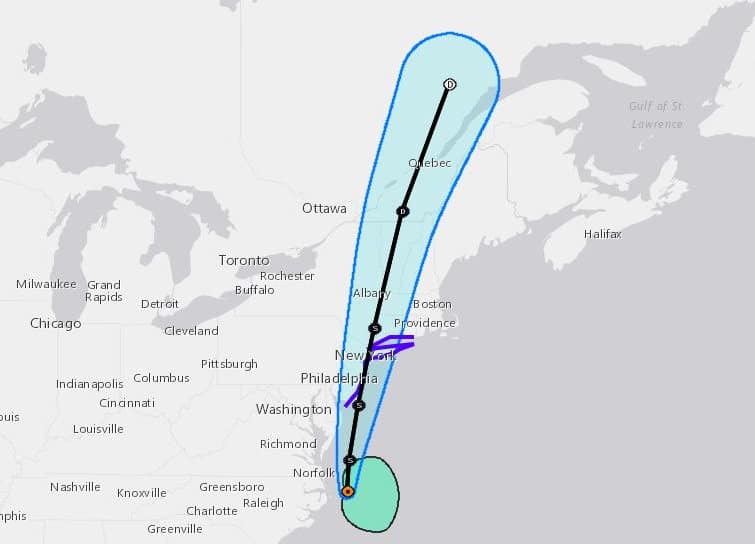
Hurricane Danielle Forecast by the National Hurricane Center in Florida for September 2, 2022. The First Hurricane of the Atlantic Season Poses No Threat to Land. Interests in the Azores should follow the storm for any changes. There are no key messages at this time. NOAA-NHC Graphic.
Forecasters Hold Firm on an Active 2022 Hurricane Season
The presence of dry Saharan dust over the Atlantic has tempered the season so far. However, in the last week, we have seen activity coming off the coast of Africa or forming over ocean water. With very warm surface temperatures, formation of tropical cyclones increases. Wind shear and dry air are the enemies of tropical cyclones. In the last week of August and the first week of September, it appears the factors inhibiting cyclone formation have weakened and we could see an above normal September and October.
Is Your Family Ready for the Next Power Outage?
With a strong La Niña present in the eastern Pacific with no sign of change and surface sea temperatures above normal in the Atlantic, early season forecasts up to the first week of July continued the previous forecast for an above average 2022 Atlantic Hurricane Season. After the third August in history without an Atlantic tropical cyclone, some forecasters have slightly lowered their expectations but continue their forecasts for above average activity.
The next two weeks should see normal activity, according to the Colorado State University Tropical Meteorology Project Forecast. In their August 4 forecast, CSU lowered the number of named storms to 18* from 20. They expect 8 hurricanes instead of 10, and 4 major hurricanes instead of 5.
As always, CSU and the NHC remind people living in hurricane-prone areas along the coasts that it only takes one storm to make their season an active season. All coastal residents should prepare for hurricane season as if they expect the next storm to land close to home.
Hurricane Season Pre—Help Your Neighbors
CSU predicts there remains a nearly 70 percent chance that a major hurricane will strike somewhere along the United States coastline. The east coast, including the Florida Peninsula, has a 43 percent chance of a major hurricane making landfall, and the Gulf Coast from the Florida Panhandle to Brownsville, Texas, also has a 43 percent chance. A 57 percent chance exists for a major hurricane to track into the Caribbean.
*The updated forecast includes Tropical Storms Alex, Bonnie, and Colin in the forecast for total named storms.
#Danielle has just reached hurricane strength in the Atlantic. Only one Atlantic #hurricane season in the satellite era (since 1966) has had no hurricanes during September: 1994. pic.twitter.com/StVze67pFp
— Philip Klotzbach (@philklotzbach) September 2, 2022
Will be ready when the next #PowerOutage strikes with a plan and supplies to keep your family and home safe and comfortable. #Outagehttps://t.co/ffp6Si5jAl pic.twitter.com/nD5RyNWSPb
— Norwall PowerSystems (@NorwallPowerSys) September 2, 2022


