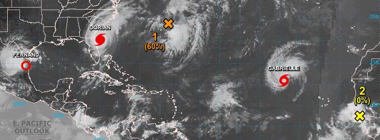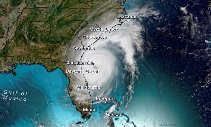
Hurricane Dorian stays just offshore of the East Coast after devastating the Bahamas and Abaco Islands with 185 MPH sustained winds. Dorian will remain a Category 2 Hurricane for the next 48-72 hours as it brushes by the North Carolina Coast or possibly makes landfall. The National Hurricane Center warns that Storm Surge could reach up 7 feet through Chesapeake Bay and flood low-lying regions from Georgia through the Carolinas. Tropical storm winds up to 75 MPH and Flash flooding is expected in conjunction with heavy rain.
The Atlantic Hurricane Season runs from June 1 through November 30. The season peaks quickly in late August and September, then declines through October.
Erin, a short-lived tropical storm, formed from Depression 6 on August 27, headed north, and was downgraded back to a depression on the 28th. The NHC issued its last update on Erin on August 29th in the 5 AM report.
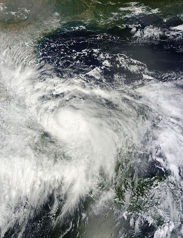
Tropical Storm Fernand made landfall in Mexico and has weakened to a depression. Fernand will bring heavy rain to portions of Mexico with the threat of landslides and flash flooding.
Gabrielle is currently a moderate tropical storm that will grow slowly over the next few days as it travels northwest over the Atlantic. The forecast shows it will organize into a hurricane in about five days provided conditions remain conducive for more development.
Another system east of Bermuda remains somewhat disorganized and has a moderate chance of forming a tropical depression in the next few days. It poses little threat to land and should move northeast into conditions unlikely to support further development.
A Tropical Wave moving off the coast of Africa today has a moderate chance of forming a depression over the weekend and may become a system to watch over the next week as it moves across the Atlantic Ocean.
Hurricanes and Tropical Storm Forecasts and Preparation

Some people ignore the forecasts of advancing storms or don’t take the warnings seriously, but not preparing for a hurricane is a mistake. Dorian is only one example of a small hurricane that grew to devastating strength and proportion. The National Hurricane Center forecasts generally look 5 days ahead. The greatest accuracy lies within the 24 to 48-hour forecast. Storm tracks show a fair degree of certainty over 48 hours but widen from 72 hours to 120 hours.
Hurricanes have the potential to take lives and destroy property. Dorian’s initial forecast as made its way through the Caribbean showed a Category 3 Major Hurricane headed for the coast of Florida. The closer it came, the stronger it grew, but the forecast also changed to update the track as further east than originally predicted. Anyone watching the storm expected a devastating Florida Landfall.
When a storm can push ten to twenty feet of fast rising water ahead of it, it puts residents in areas like Florida and the East Coast in extreme danger. Today, portions of the Bahamas are still under water from the storm surge and the heavy rainfall. Storm surge is responsible for the greatest number of fatalities. Unfortunately for Abaco and Bahama Islands, they took the full brunt of a Category 5 Hurricane. Reports of a 20-foot surge put large portions of Grand Bahama Island under water.
Everyone living on the Atlantic or Gulf Coast should have a hurricane plan that includes a backup power source and an evacuation plan in place. Hurricanes brings dangerous storm surge, a mound of water that moves with the storm as it advances toward land or moves up the coast as Dorian is doing.
Know your risks. Make your plans. You’ll be ready when the next hurricane makes landfall near you, or you might get to breath a sigh of relief when it turns away.
Either way, you were ready, and you won’t ever regret lack of preparation.


