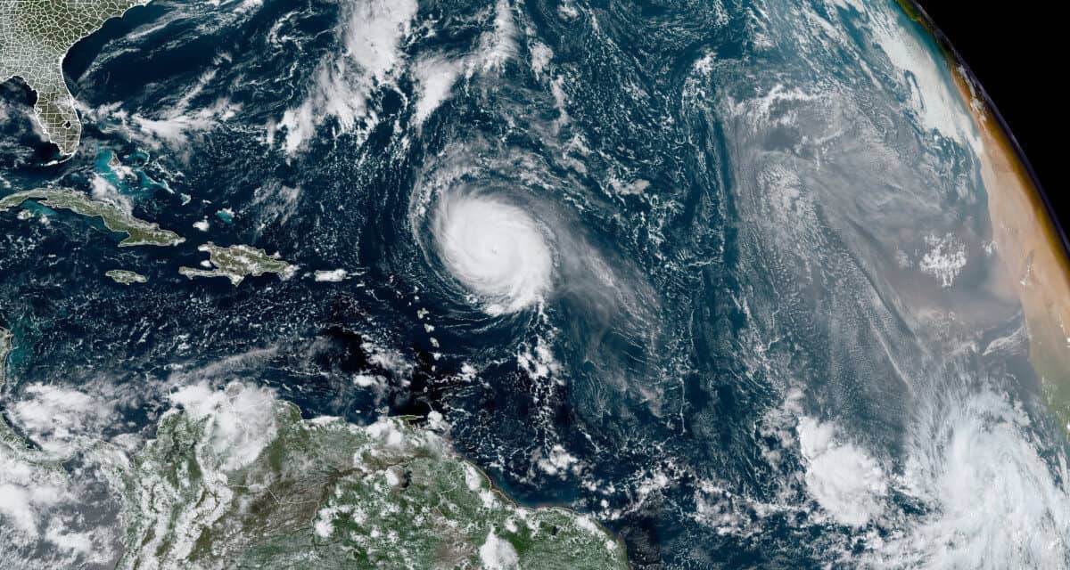
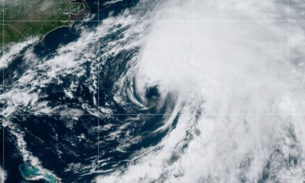
Category 4 Hurricane Sam Churns over the Atlantic several hundred miles east of the northern Leeward Islands. The main circulation is about 320 miles. In the lower left of the image is newly formed Tropical Depression Twenty. NOAA Satellite Image.
Tropical Pacific La Nina Forecast May Extend Hurricane Activity
Since forming late last week, Hurricane Sam plodded through the Atlantic from southwest of the Cabo Verde Islands off the coast of Africa to east of the northern Leeward Islands. Sam is a powerful category 4 hurricane with 130 MPH sustained winds that gust up to 165 MPH. Current movement is to the northwest at 9 MPH. Sam is the nineteenth named storm of the 2021 Atlantic Hurricane Season.
Hurricane Sam will remain over warm ocean water through most of the week in an area with low wind shear. By Friday, it will pass 100 to 300 miles east of Bermuda as a category 3 storm. The forecast track through Friday shows a gradual turn to the north and then to the northeast by the weekend.
Two Months Left in a Very Active 2021 Hurricane Season
Heavy surf and rip currents are the primary threats to the Lesser Antilles Islands and extend to the Bahamas and to Bermuda by the weekend. Although powerful, Sam is a relatively small storm with hurricane-force winds extending up to 40 miles from the storm center, and tropical-storm-force winds up to 160 miles from the center. If Sam moves closer to Bermuda, the NHC may issue Tropical Storm warnings or watches. The latest public advisory and discussion does not expect any watches or warnings, although additional strengthening is possible.
As seen in the GOES East Satellite image, Hurricane Sam has a well-defined shape and a visible, well-defined eye.
Hurricane Sam Strengthening Rapidly on a track heading slightly north of the Leeward Islands. Sam could reach Category 4 by Saturday according to some forecasts. #HurricaneSam #HurricaneSeason2021https://t.co/Aym2EZWGKS pic.twitter.com/ZSB0GesXu2
— Norwall PowerSystems (@NorwallPowerSys) September 24, 2021
Tropical Depression Twenty Likely to Become Hurricane Victor
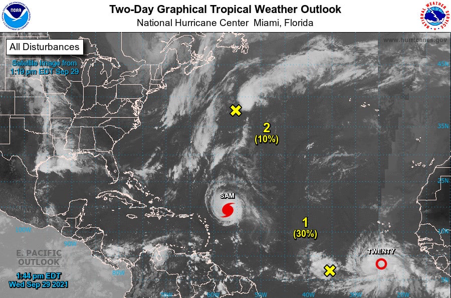
Elsewhere, forecasters at the NHC are watching Depression Twenty after it formed this morning near the Cabo Verde Islands, very close to the location where Depression Nineteen formed before becoming Hurricane Sam. Twenty should gather strength from the warm ocean over the next few days and become a tropical storm by Thursday, and a hurricane by Friday.
Depression Twenty will receive the name Victor after becoming a tropical storm. As the cyclone moves west, it will gradually turn to the northwest and then nearly north. By Sunday, the NHC expects Victor to weaken back to a tropical storm as it heads into the central Atlantic.
How to Use a Portable Generator for Emergency Power
Two other areas of possible development are under observation. The remnants of post-tropical cyclone Peter northeast of Bermuda had a medium chance of development until this morning. It is now headed toward colder water and strong upper level winds. Chances of development are low, around ten percent.
The low-pressure trough west of Tropical Depression Twenty remains disorganized and is interacting with Depression Twenty, which reduces its chance of development. It is drifting west-northwest toward the Lesser Antilles. For the next few days, it has a thirty percent chance of further development. If it reaches the Caribbean, conditions there could help it develop into the next depression or named storm.
Tropical Depression 20 is forecast to become a #hurricane on 1 October. The 2021 Atlantic hurricane season has already had 7 hurricanes. 7 seasons in satellite era (1966 onwards) have had 8+ Atlantic hurricanes by 1 October: 1969, 1995, 2004, 2005, 2012, 2017, 2020. pic.twitter.com/DnPxHOBGkU
— Philip Klotzbach (@philklotzbach) September 29, 2021
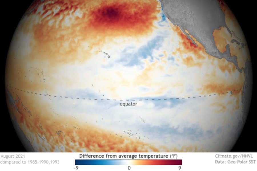
La Nina Forming in the Eastern Pacific May Extend Atlantic Tropical Activity
Last week’s announcement that the El Nino Southern Oscillation (ENSO) is shifting from a neutral state to a La Nina affects this year’s hurricane season and the coming winter in North America. La Nina is a cooler than average ocean surface and is one factor that drives greater tropical cyclone activity in the Atlantic. It is one of the major factors that forecasters use to forecast Atlantic hurricane season activity.
Buyer Guide to the Best Portable Generator for Home Use
As the shift toward La Nina continues, more tropical cyclone activity in the Atlantic becomes a possibility. Although the season is three weeks beyond the historical average peak, October is also historically an active month with the number of cyclones gradually tapering off close as November approaches.
Mid-season forecast updates included up to 26 named storms from organizations like Accuweather.com Hurricane Forecast, the National Hurricane Center Seasonal Outlook, and Colorado State University’s Tropical Weather and Climate Research Project.
Standby Generators Run in Any Weather Including Hurricanes
The La Nina formation announcement has weather forecasters hastening to update their winter weather forecasts for the United States and Canada. Early snow and a colder than average winter appear likely as the La Nina forms. It could also mean some rain for the drought stricken West and sub-zero cold from the Great Plains to the Northeast.
Upper-ocean heat content anomalies in the eastern and central tropical Pacific have dropped considerably in past two weeks, likely a harbinger of a transition to #LaNina shortly, especially when combined with continued strong trade winds across eastern/central tropical Pacific. pic.twitter.com/gCYBYXuXmt
— Philip Klotzbach (@philklotzbach) September 20, 2021

