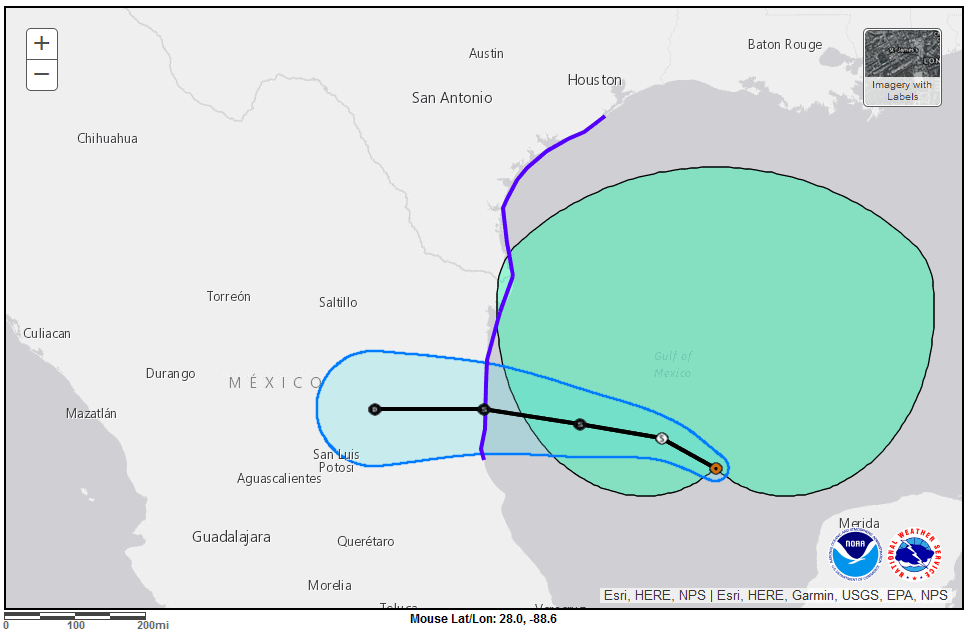
Tropical Storm Warnings extend from Ciudad Madero Tempico, Mexico, North to Brownsville Texas through West Bay south of Galveston. Deteriorating conditions along the Texas Coast will result in Heavy Rain, Coastal and Flash Flooding, Storm Surge, Possible Tornadoes, High Winds, and Dangerous Surf Conditions with Rip Currents. NOAA-NHC Graphic.
Update June 19. The National Hurricane Center has upgraded PTC1 to Tropical Storm Alberto.
Alberto will make Landfall early tomorrow morning before 7 AM with 45 MPH sustained winds and 60 MPH gusts. Check your local weather and official government sources for the latest in your area.
Potential Tropical Cyclone 1 Expected to Organize Before Landfall
The National Hurricane Center has issued tropical storm warnings for the Texas coast from Brownsville to south of Galveston, near the southern portion of West Bay. Although not yet classified a tropical storm, the low-pressure system that makes up Potential Tropical Cyclone 1 is producing tropical storm force winds in excess of 39 MPH.
The system is much larger than the forecast cone might lead some to believe, with tropical storm force winds extending several hundred miles to the north.
This storm will impact the Texas Coast from Brownsville through Galveston.
Conditions are deteriorating along the Texas coast and will continue to worsen through Wednesday.
Mike Brennan, Director of the National Hurricane Center, provided a live update at 4:15 PM Central Time today.
🌀#HurricanePrep 📝Make a Plan. Prepare Your Home and Family. Know Where to Go if You Must Evacuate 🚕Don't Forget About Your Pets 🐈 They Need a Plan Too! #HurricaneStronghttps://t.co/2NsT3fis84
— Norwall PowerSystems (@NorwallPowerSys) June 3, 2024
Texas Coast and Inland—Key Hazards
- Heavy rain of 5-10 inches, with local totals up to 15 inches, primarily in the Corpus Christi region.
- Coastal Flooding with storm surge inundation of 2-4 feet, especially in the Galveston area.
- Flash Flooding near the coast and inland.
- High winds of at least 40 MPH with higher gusts.
- Heavy Surf and dangerous Rip Currents are creating life-threatening conditions.
- Wednesday brings a risk of tornadoes throughout the day.
The system is a wide low-pressure system across the south central Gulf of Mexico with sustained winds of 40 MPH. Large storm bands located over the northern Gulf are moving Northwest and West toward the Texas coast. The system lacks rotation and organized thunderstorms about the center—thus the NHC classifies the storm as a potential tropical cyclone though tropical storm force winds extend hundreds of miles north of the center.
The National Hurricane Center expects the potential tropical cyclone to organize as a tropical storm before it makes landfall.
Flood Watches are in effect for the entire Texas Coast and Inland to San Antonio and Eagle Pass down to Laredo through Brownsville. Lessor amounts of rain will contribute to ongoing flooding in the Houston Galveston Area. Expect flash flooding from the Houston-Galveston area through Port Arthur, Beaumont, and Corpus Christi.
The risk of flash flooding extends inland to the northwest on Thursday from Brownsville to Victoria, Eagle Pass to Laredo.
The NHC forecasts storm surge inundation for the entire Texas coast, with 2-4 feet from Sabine Pass at the Texas-Louisiana Border to Sargent.
Director Brennan reminded residents to stay out of the water, and to turn on multiple emergency weather alerts through the night to stay informed and updated on changes to watches and warnings.
Norwall Resources: Hurricane Preparedness
- Hurricane Hazards and Risk Factors
- Make a Hurricane Evacuation Plan
- Hurricane Preparedness Kits and Supplies
- Hurricane Insurance Checkup and Updates
- Prepare Your Home for Hurricanes
- Help Neighbors with Hurricane Preparedness
- Complete Your Hurricane Preparedness Plan
- Emergency Preparedness Tips
- How to Prepare for a Power Outage
- 10 Tips to Survive a Hurricane Disaster
- FEMA Recommends a Generator
- Hurricane Disaster Preparedness
Atlantic #HurricaneSeason Outlook 2024: 17-25 named storms of which 8-13 could become hurricanes, including 4-7 major hurricanes:https://t.co/xYeB7wLLIg@NWSCPC #HurricaneOutlook #WeatherReadyNation pic.twitter.com/4GskgPkAsF
— NOAA Communications (@NOAAComms) May 23, 2024


