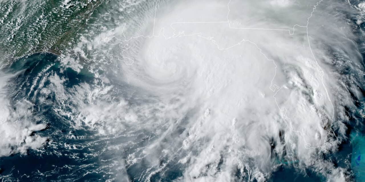
Hurricane Sally Satellite Image Saturday September 13, 2020 4:40 PM CDT.
NOAA GOES 16 Satellite Image
Sally to Intensify in Advance of Landfall as Catetory 1 Hurricane
Update: September 13, 2020. The National Hurricane Center now forecasts Hurricane Sally to intensify to Category 3 before making landfall within the hurricane warning area. from Louisiana to Mississippi. Landfall could occur anywhere within the warning area.
An extremely dangerous storm surge with in the warning area from Port Fourchon, Louisiana to Okaloosa/Walton County line in the Florida Panhandle. Storm surge could reach 10 feet or more for as Sally slows to a few MPH on landfall.
Flash flooding is likely with areas of minor and major flooding along rivers and inland from the coast.
Widespread minor and major flooding through the week is expected along the rivers. Sally could produce flash floods across the Florida Peninsula today and tonight.
Flooding impacts are epected to spread southeast through the middle of the week.
—
The Atlantic Hurricane Season usually peaks on September 10, but the already active season has turned hyperactive with three named storms in the Atlantic basin and two more likely to form in the next 48 to 72 hours.
Tropical Storm Sally—soon to be Hurricane Sally—is the latest storm to threaten the United States just four days after forming a cyclone near Florida.
Tropical Depression Nineteen formed east of Florida late Friday afternoon. The National Hurricane Center hurried to issue a tropical storm watch for east Florida and warned that Tropical Storm Warnings and Hurricane Warnings for the northern Gulf Coast were likely. Twenty-four hours later after crossing the tip of the Florida Peninsula, the depression emerged over the Gulf of Mexico as Tropical Storm Sally.
The National Hurricane Center Hurricane in Florida issued Hurricane, Tropical Storm, and Storm Surge watches encompassing the Florida Panhandle to Vermillion Bay, Louisiana. Most of the watches have since turned into warnings. The current track takes Sally into land at the Mississippi Delta and New Orleans.
Sally will land as a strong Category 1 hurricane with sustain winds from 80 to 90 MPH and gusts to 115 MPH.
#Sally will produce very heavy rainfall resulting in widespread significant flash flooding and minor to isolated major river flooding across southeastern Louisiana, Mississippi, and Alabama through the middle of the week. See @NWSWPC and your local @NWS office for details. pic.twitter.com/GoySWbQVSR
— National Hurricane Center (@NHC_Atlantic) September 13, 2020
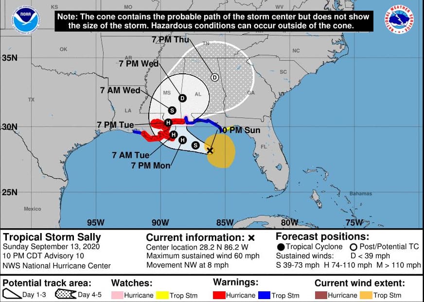
Sally Hazards, Watches, and Warnings
The storm surge warning includes the Mississippi Delta, New Orleans, Lake Pontchartrain, and the Mississippi Gulf Coast from Louisiana to the Alabama state line. A storm surge watch includes the entire Alabama Gulf Coast from Louisiana to Florida. The storm direction and speed will produce a prolonged surge event up to 10 feet above high tide. The National Hurricane Center is calling this an extremely hazardous situation. Storm surge and flooding account for more deaths and property damage than all other storm hazards combined.
A Hurricane warning is in effect from Morgan City Louisiana to Ocean Springs, Mississippi. Tropical Storm conditions will begin on Monday. Landfall with hurricane conditions is expected shortly after midnight on Monday, around 1 AM on September 15. Tropical storm winds range from 40 MPH to 74 MPH. A category 1 hurricane has sustained winds up to 95 MPH.
Devastating Damage From #HurricaneLaura2020. #Evacuation and #Shelter Limited by #COVID19 #Coronovirus. Wide-Spread #PowerOutages amid 90 deg. Temps and Humidity. https://t.co/Iphfg6hRUF pic.twitter.com/zqzQWhgLjl
— Norwall PowerSystems (@NorwallPowerSys) August 27, 2020
Hurricanes and tropical storms cause power outages that last for days or weeks. Heavy rain and storm surge bring extensive flooding. The prolonged 10-foot surge event with fast moving water causes structural damage to buildings and makes rescues difficult or impossible.
Residents are urged to rush to complete preparations ahead of Sally. At least five parishes have issued evacuation orders, including some mandatory evacuations surrounding New Orleans. Those evacuating should leave as soon as possible.
COVID-19 rules for social distancing will make public evacuations difficult and overwhelm public shelters.
Mississippi Governor Tate Reeves and Louisiana Governor John Bel Edwards have declared a state of emergency in advance of the storm. Louisiana is still reeling from Category 4 Hurricane Laura just a few weeks ago. President Trump has declared the damage from Laura a Major Disaster. Governor Edwards asked the President for an advance declaration before Sally hits.

