Complete Preparations and Mandatory Evacuations as Florence Nears North and South Carolina
September 12, 2018 Key Messages from the National Hurricane Center:

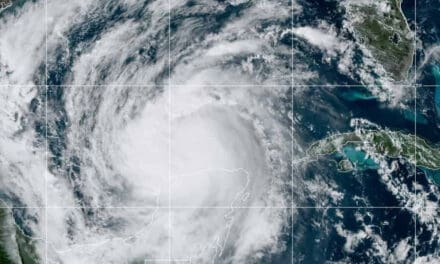
Category 4 Major Hurricane Florence as Seen From the International Space Station (ISS) on September 10 – Astronaut Ricky Arnold.
Life-threatening storm surge is likely along the North Carolina and South Carolina Coasts, and a Storm Surge Warning remains in effect. Complete Preparations and follow the direction and advice given by local officials.
South Carolina Evacuation Orders
North Carolina Evacuation Orders
Life-threatening catastrophic flash flooding and river flooding is likely over much of the Carolinas beginning Thursday-Friday and will last into early next week. Florence will slow as it reaches land and moves inland.
A Hurricane Warning remains in effect for the South and North Carolina Coastlines. Strong winds will spread inland as the hurricane comes ashore.
Life-threatening surf conditions and rip currents will continue to affect the East Coast.
Scroll to the end of the article for additional Resource Links.
Portable Generator Safety Rules to Live By
How to Use a Portable Generator for Emergency Power
September 11, 2018 Update:

Timing of Hurricane and Tropical Storm Force Winds
Mandatory Evacuation orders are in place for coastal areas in South Carolina and North Caroline as Category 4 Florence heads for the coast. This storm will stall once making landfall and have long-lasting, life-threatening impacts. Rainfall may reach 30 inches in some areas of South and North Carolina with 15 to 10 inches common, according to the National Hurricane Center’s 11:00 AM update.
South Carolina Evacuation Orders
North Carolina Evacuation Orders
The NHC issued a Hurricane Watch for South Carolina and North Carolina extending from the Georgia border to the Virginia border. A Watch indicates hurricane conditions will arrive within 48 hours. Once the NHC issues Hurricane Warnings, less than 36 hours remain until hurricane conditions arrive. The coastline is also under a storm surge warning with surge possibility highest along tributaries where water will “stack up” as the surge pushes inland and reverses the river flow direction.

Expected Rainfall Totals From Hurricane Florence over North and South Carolina (Click to Enlarge)
All residents should hasten to complete preparations and those under evacuation orders should follow direction by local governments.
Florence will bring life-threatening surge, dangerous inland flooding, and catastrophic damage. Expect widespread power outages. This storm will remain over South and North Carolina for up to two days before moving on. Be prepared with nonperishable food and enough drinking water for one week.
NHC Key Messages as of 11:00 AM September 11:
The NCH issued a storm surge warning for portions of the North and South Carolina and Virginia coastlines. All interests from South Carolina into the Mid Atlantic should have their hurricane plan in place.
Life-threatening and catastrophic flash flooding and river flooding is possible from late this week into next week. Florence will slow down and remain over the region as it dumps 15-20 inches of rain and up to 30 inches in some locations.
Damaging hurricane strength winds will reach the Carolina coasts; tropical storm force winds will extend much further. Damaging winds will spread inland through the Carolinas and Virginia.
Life-threatening swells and rips currents will continue along much of the coast.
Update September 10, 2018:

#HurricaneFlorence has reached Category 4 and continues to intensify. Put your Hurricane Plan into Action Now.
Forecast models for Major Hurricane Florence continue to solidify. The storm wind-field will grow and will become a large and dangerous storm by the time the hurricane reaches land. A distinct eye formed and convection continues to increase. In its 11 AM EDT discussion update (10-Sept,) the NHC stated that rapid intensification would result in Category 4 by tomorrow. According to AccuWeather, Florence reached Category 4 today and could reach category 5 before making landfall. Category 4 wind speed falls in the 131 to 155 MPH range with higher gusts.
High Surf and Rip Currents already pose life-threatening hazards. Tropical-storm-force winds of 39MPH or higher will arrive on the shoreline by 8 AM Wednesday, with landfall on Thursday morning. The current track, which is subject to change, puts landfall between Myrtle Grove and Masonboro North Carolina.
The NHC cautions residents not to focus on the storm track. This storm is large and dangerous. Storm conditions will reach along the coast far from the storm track. Those living in evacuation zones should prepare to evacuate.
Put Your Hurricane Plan Into Action Now
Key Messages from the NHC on September 10, 2018, 11:00 AM EDT: Life-threatening storm surge is likely. The NHC will issue storm surge warnings as early as Tuesday morning. All residents and interests from South Carolina to the mid-Atlantic region should have their hurricane plan in place and follow local government advice.
The NHC expects a prolonged and heavy rainfall event to bring life-threatening inland flooding which may extend over the Carolinas and the Mid Atlantic for hundreds of miles. Florence will slow down upon making landfall and remain a hurricane for 24 hours or more.
Expect damaging hurricane-force winds along the North Carolina and South Carolina Coasts. The NHC will begin issuing Hurricane Watches sometime Tuesday morning.
The large swells affecting Bermuda and the East Coast will continue through the week and result in life-threatening rip currents and surf conditions.
Scroll Down for Preparedness advice and Links to Resources.
September 9, 2018 Update:

Hurricane Florence Reached Category 4 today, September 10
Florence strengthened over the last two days and has reached the warm deep water and environmental conditions necessary for further intensification. Once again, a hurricane, Florence will strength rapidly and become a Major Hurricane by late Monday. Forecasters expect the storm to reach Category 4 by Tuesday.
High-pressure systems to the north and south of the current track will steer the hurricane into the shore. The certainty of the general track has increased, but the exact path and landfall location remain somewhat unclear. The current track brings Florence ashore along the North Carolina Coast north of Long Bay. Tropical-Storm-Force Winds will arrive by Thursday Morning. High Surf and Dangerous Rip Currents already present life-threatening hazards. Florence brings Storm Surge, Inland Flooding, and Extreme winds. Hurricanes often spawn tornadoes.
South Carolina, North Carolina, and Virginia have declared a state of emergency. Residents and interests along the East Coast now have less than four days to prepare for the hurricane. Put your hurricane plan into action and complete preparations before Thursday Morning.
If you live in an evacuation zone, prepare your home and family and be ready to leave when officials give the order to evacuate. The likelihood that this storm will make landfall as a major hurricane has increased. Category 4 is a dangerous storm with unrelenting winds up to 155 MPH and higher gusts.
Key Message from the NHC on 9 September 2018: The risk of life-threatening impacts from Hurricane Florence has increased. Coastal Storm Surge and Inland Flooding due to prolonged, heavy rain will occur. The exact timing and location of these impacts remain uncertain. Interests along the coast and inland from South Caroline to the mid-Atlantic region should closely monitor Florence and review their hurricane plan. Follow advice by local officials.
Scroll Down for Preparedness advice and Links to Resources.
September 7
May Strengthen to a Major Hurricane Before Making Landfall Next Week

This Image from Hurricane Harvey Shows Storm Surge Coming Ashore
Florence, once a major category three hurricane, lost strength while battling wind shear, but remains a strong tropical storm with 65 MPH winds. Forecasters at the National Hurricane Center expect the storm to strengthen again to hurricane strength by Sunday morning and intensify to a Major Category 3 Hurricane (111 MPH to 130 MPH) by Tuesday when it will pass south of Bermuda
According to AccuWeather’s Atlantic Hurricane and Tropical Storm Center, residents along the East Coast should closely monitor Florence through the weekend and early next week. Although too early for a definitive track, it appears likely that the hurricane will make landfall somewhere along the South Carolina coast or further north.
Key Messages from the National Hurricane Center:
- Large swells from Florence will begin to affect Bermuda today and the U.S. East Coast this weekend with life-threatening surf and rip currents.
- Risk of direct impacts on the East Coast has increased, but the uncertainty of long-range forecasts makes it difficult to predict the impacts and location of those impacts. Residents and interests along the East Coast should review their Hurricane Preparedness Plans.
Hurricane Preparedness: Know Your Risks – Make Your Plans
Hurricane Preparedness Plans

Hurricane Preparedness Requires Time and in the Last Few Hours, Supplies Become Difficult to Find.
The current forecast remains unclear, but Hurricane Florence will affect the East Coast whether it makes landfall or turns north and skims the coastline. With a week to prepare in advance, East Coast residents and interests have time to ensure their homes, families, and properties are ready for the storm.
- Find out if you live in a hurricane evacuation zone and learn your evacuation route. Drive the route from your home to learn it. Determine your destination where you will wait for the storm to pass. Let relatives know in advance.
- Order emergency supplies of medication. Your supply of medicine should last at least a week after the storm’s arrival. Some medications require refrigeration. Determine how to keep it cold if the power goes out for an extended period. Portable Generators can keep a refrigerator and freezer cold and a few other necessities.
- As the storm approaches, the demand for products and supplies increases. Check supplies of plywood for boarding up windows and doors, purchase bottled water or containers for bottled water, and nonperishable food.
- Keep vehicles filled with fuel. If you plan to use a portable generator during a power outage, stock up on fuel now and purchase maintenance items like filters, oil, and spark plugs. Pure gasoline without ethanol works best. Most communities limit residential supplies to 25 gallons or less. Don’t forget to add stabilizer for long-term storage.
- Each person needs at least one gallon of water per day for drinking and washing. Store water in gallon-size or larger containers. Bottled water is fine for drinking; use larger containers for washing and sanitation.
- Check your stock of nonperishable food. Have enough on hand for one week. Foods that require heating will require a heat source like a camp stove, or you might be able to use your gas range. Check out other options for Cooking During a Power Outage.
- Don’t forget about your pets. If you evacuate, take them with you. Every hurricane that makes landfall leaves heartbreaking stories in its path of pet owners who were forced to leave their pets behind. Most shelters don’t allow you to bring pets. Remember they also need food and water, and you must deal with their waste too.
What to Do – Hurricane Watches – Warnings – Action Steps
Resources

Power Expert: Norwall PowerSystems has articles on hurricane and disaster preparedness, safe use of generators, and more.
Ready.gov: FEMA’s Emergency Preparedness Site carries both state and local information. During a disaster. Bookmark this page in your mobile phone browser for easy use.
FEMA App: For Android and IOS. Provides localized alerts about storms and hazards along with how to respond to an alert, prepare, and other disaster resources.
National Hurricane Center: Provides information on approaching tropical cyclones including Tropical Depressions, Tropical Storm, Hurricanes, and Major Hurricanes.
National Weather Service: Localized information on weather and storms. Useful during a hurricane disaster for tornado warnings, flood warnings. Find your local forecast and bookmark.
Red Cross: Responds to disasters and provides emergency services including food, shelter, relief supplies, and first aid assistance.
Portable Generators for Disasters: Portable Generators large, small, and in between to meet virtually every need during a disaster.
Home Backup Generators: Permanently connected, supplies power automatically without setup. Reliable. Home Standby Generators don’t need constant refueling.


