Milton Second Strongest Gulf Hurricane in History
Landfall Near Tampa Bay—St. Petersburg Wednesday at Category 3 to 4
Update: October 8, 2024:
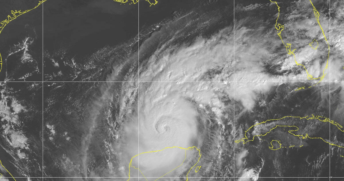
Major Hurricane Milton rapidly intensified from a Tropical Storm to a Category 5 Hurricane with 180 MPH winds between Sunday evening and Monday morning. A hurricane hunter aircraft recorded a near record low of 897mb, or 26.49 inches of mercury. Milton ties the third-place record for strongest winds, and is the second strongest hurricane in the Gulf of Mexico. Hurricane Rita in 2005 had 180 MPH winds and a low pressure of 895 mbar.
Milton has weakened slightly since the near record strength recorded yesterday. The National Hurricane Center in its discussion this morning that Milton underwent a complete eyewall replacement. Eyewall replacement is common in strong hurricanes and a signal that the size of the storm is growing.
By landfall, the width of hurricane and tropical storm force winds will extend well beyond the current forecast cone.
Hurricane Milton NHC Key Messages
- Milton will make landfall near the Tampa Bay-St. Petersburg area late Wednesday afternoon, early evening as a category 3 or possible category 4 hurricane.
- Hurricane Milton will grow in size as its winds slightly decrease. At landfall, hurricane force and tropical storm force winds will extend beyond the currrent forecast cone.
- A deadly 10 to 15 foot storm surge will inundate the landfall area, and life-threatening surge is forecast for the entire Florida Penisula Gulf Coast. Storm Surge Watches and Warnings up to 6 feet are in effect for the Atlantic Coast extend from Sebastian Inlet north to South Santee River in South Carolina.
- Milton will remain a hurricane as it crosses the peninsula before entering the Atlantic Ocean near or at Cape Cananveral, where hurricane warnings are now in effect.
- Heavy rainfal ahead of Milton’s arrival through Thursday will cause flash and urban flooding. Tornadoes are associated with the hurricane are also possible.
🚌 10/8: TODAY there are free evacuation shuttles operating in Pinellas, Pasco & Hillsborough counties helping residents reach shelters for #Milton.
— FL Division of Emergency Management (@FLSERT) October 8, 2024
➡️ You can find shuttle locations & times at https://t.co/nfDMe4HFPM under the Evacuation Assistance tab. https://t.co/KeV77ufQX9
Check Your Zone
If you are in an evacuation zone, make use of a shuttle in your county to evacuate to a shelter, or fill your vehicle with fuel and leave along a designated Hurricane Evacuation Route.
Florida Resources
10/8 10am CDT: A large area of destructive storm surge from #Milton will occur along parts of the west coast of Florida on Wednesday.
— NHC Storm Surge (@NHC_Surge) October 8, 2024
This is an extremely life-threatening situation & residents should follow advice from local officials & evacuate immediately if told to do so. pic.twitter.com/mtzYc38l81
Listen to local officials! #Milton is approaching fast, and conditions could change rapidly.
— FEMA (@fema) October 8, 2024
Stay tuned to all official updates for the latest evacuation orders and safety information.
If told to evacuate, do so IMMEDIATELY! pic.twitter.com/dU5C7TXPog
Did you know?
Water in the form of storm surge and inland flooding is responsible of 50% of all deaths and damage associated with a hurricane.
Hurricane Milton Forecast—Cat 3 Major Hurricane by Landfall
Saturday, October 5, 2024, Gulf of Mexico. The broad area of showers and thunderstorms that extended from the Western Caribbean Sea into the Gulf of Mexico over the past week has organized into Tropical Storm Milton. Milton will strengthen overnight and tomorrow into a Hurricane by Sunday morning. By 1:00PM Tuesday, it should reach Category 3, a Major Hurricane.
The current National Hurricane Center forecast indicates a landfall near Tampa Bay on Wednesday at approximately 1:00 PM as a Category 3 storm. However, the forecast cone encompasses nearly the entire Peninsula from the Big Bend Region to the Everglades, but not the Florida Keys.
Tropical Storm Milton Key Messages
- Milton will intensify quickly over the next 36 hours as it moves eastward cross the Gulf of Mexico. It will be at or near major hurricane strength when it reaches Florida midweek.
- Expect Life Threatening Storm Surge across portions of the west Florida Coast beginning late Tuesday or Wednesday.
- Residents along the western coast should have their hurricane plans in place and be prepared to evacuate.
- Follow advice from local officials. Stay tuned to the National Hurricane Center, and Local Weather for updates.
- Areas of heavy rain up to 12 inches on Sunday and Monday will precede hurricane’s arrival on Wednesday. Flash, urban, and area flooding. Minor to moderate river flooding is possible.
- Swells from the storm will begin affecting the west Gulf Coast today and spread north and east, and bring life-threatening RIP currents and Surf.
Hurricane Preparedness
- Hurricane Hazards and Risk Factors
- Make a Hurricane Evacuation Plan
- Hurricane Preparedness Kits and Supplies
- Hurricane Insurance Checkup and Updates
- Prepare Your Home for Hurricanes
- Help Neighbors with Hurricane Preparedness
- Complete Your Hurricane Preparedness Plan
- Emergency Preparedness Tips
- How to Prepare for a Power Outage
- 10 Tips to Survive a Hurricane Disaster
- FEMA Recommends a Generator
- Hurricane Disaster Preparedness
Automatic Briggs & Stratton Home Generator Starts/Runs Automatically—Even in a Hurricane
4PM CDT Oct 5: Tropical Storm Milton is forecast to strengthen quickly and bring the risk of life-threatening impacts to portions of the west coast of Florida Tuesday or Wednesday. Make sure to check back for updates through the weekend and into next week at… pic.twitter.com/ODXkMcuLAz
— National Hurricane Center (@NHC_Atlantic) October 5, 2024
Now is the time to prepare for #Milton if you live in #Florida! Get your supplies replenished & remember to include your pets! Visit https://t.co/RpQ6ZejVlK to find your evacuation zone. For information on the latest forecast, visit https://t.co/HwaVRhSa8B https://t.co/TF81M0uk9R
— National Hurricane Center (@NWSNHC) October 5, 2024
Tropical Storm Milton has formed in the southwest Gulf of Mexico. Milton is forecast to strengthen into a major hurricane and move northeast and impact Florida midweek.
— NWS Tallahassee (@NWSTallahassee) October 5, 2024
Keep updated of TS Milton at https://t.co/VS96jxeUGj and https://t.co/vH6hBhFjeA #FLwx #GAwx pic.twitter.com/VCMp4CzopS


