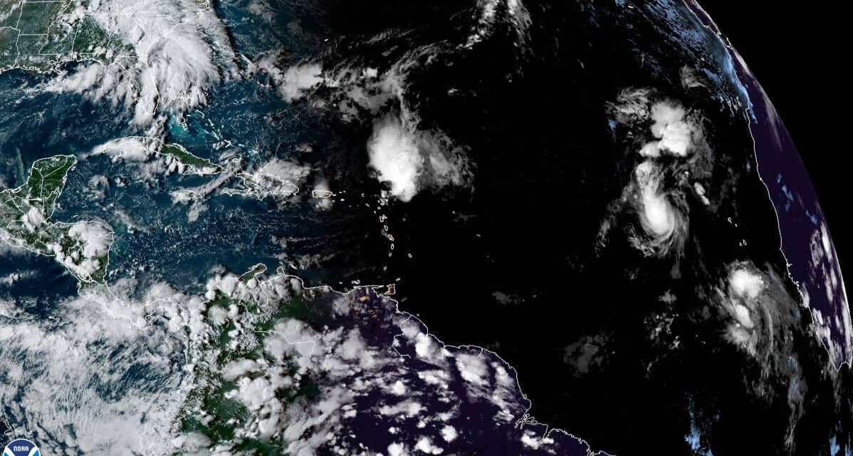
Satellite image shows the active Tropical Atlantic with Tropical Storm Peter and Tropical Storm Rose. At the far right is a tropical wave that emerged off the coast and will probably be the next tropical cyclone in the 2021 Hurricane Season.
NOAA Satellite Imagery on September 20, 2021.
Sixteenth Named Storm Forms as Season Shows No Sign of Slowing
With more than two months left in the season, the Atlantic Basin shows no sign of slowing. Tropical Storm Peter developed out of Depression Sixteen late in the afternoon on Saturday, September 18. Earlier in the week, forecasters began watching a low-pressure system that moved off the African Coast near the Cabo Verde islands. The system moved generally west northwest. On Saturday afternoon, it organized into Tropical Depression Sixteen. A few hours later, the NHC upgraded Depression Sixteen to a tropical storm and named it Peter.
Peak Atlantic Hurricane Season Above Average Activity
Tropical Storm Peter moved northwest and is currently about 150 miles north of the Leeward Islands. Heavy rain could cause some flooding across the Leeward Islands with some heavy surf conditions. The National Hurricane Center has not issued warnings or watches for Peter.
Peter is battling strong wind shear. Most of the storm’s wind field is northeast of the center, well away from the Caribbean Islands.
Standby Generators that Run During Hurricanes
Despite battling wind shear, Tropical Storm Peter has sustained winds of 50 MPH with higher gusts. It should continue to track northwest for the next two days and gradually weaken due to the strong wind shear. A turn to the north and northeast and it should weaken to a depression on day three (Thursday) and four. Gradual strengthening should follow as it moves toward Bermuda and it could regain tropical storm strength by Saturday.
Here are the 11 AM AST September 20 Key Messages for Tropical Storm #Peter. More info: https://t.co/tW4KeFW0gB pic.twitter.com/fCbOqIOHvo
— National Hurricane Center (@NHC_Atlantic) September 20, 2021
Tropical Storm #Peter Advisory 6: Air Force Hurricane Hunters Find Peter a Little Stronger. Peter Expected to Pass North of the Leeward Islands Early This Week. https://t.co/VqHn0u1vgc
— National Hurricane Center (@NHC_Atlantic) September 20, 2021

More Tropical Systems in Development
In the Northern Atlantic, the Post-Tropical Cyclone Odette is slowly moving south over warmer water with 60+ MPH sustained winds. Odette could redevelop as a tropical storm, but currently has just a 30 percent chance over the next five days. Odette should turn to the north again and move over cold water later this weekend.
Hurricane Season Preparedness Planning Checklists
Tropical Storm Rose, the seventeenth named storm of the 2021 Hurricane Season, is east of the Cabo Verde Islands on a northerly track. Rose has maximum sustained winds of 40 MPH. Rose is currently moving northwest as it heads into a region of wind shear. It will lose strength by Wednesday and become a tropical depression. Forecasters expect a turn to the northeast on Thursday and Friday. The system will probably become post-tropical on Saturday.
A tropical wave that emerged off the Coast of Africa is located south of the Cabo Verde islands and moving west. Chances for development in the next five days are about 80 percent. The system is moving in an area of low wind shear and warm ocean water, good conditions for development. A tropical depression will probably form by Thursday of Friday, according to the NHC. It would be named Tropical Storm Sam if it develops.
How to Prepare for a Power Outage
The 2021 Hurricane Season has already produced 17 named storms, above average activity. With more than two months left, the Atlantic Basin, the Caribbean, and United States Coastlines could see more hurricanes and tropical storms before the season ends on November 30.
Upper-ocean heat content anomalies in the eastern and central tropical Pacific have dropped considerably in past two weeks, likely a harbinger of a transition to #LaNina shortly, especially when combined with continued strong trade winds across eastern/central tropical Pacific. pic.twitter.com/gCYBYXuXmt
— Philip Klotzbach (@philklotzbach) September 20, 2021


