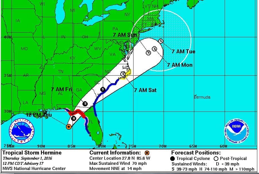
Tropical Storm Hermine may reach the Florida Coast at near hurricane strength.
(NHC Image)
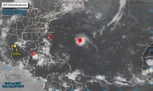
Current Storms in the Atlantic and Gulf of Mexico
(NOAA Image)
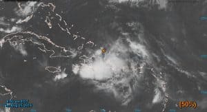
The Tropical Wave with the potential to organize into Tropical Storm Hermine.
(NOAA Image)
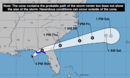
Update: 1 September 2016 2:00 PM Eastern: The National Hurricane Center has extended the Hurricane Warnings and Tropical Storm Warnings much further along the coast. The storm surge forecast has increased up to 8 feet in some locations. TS Hermine will almost certainly strengthen to a Hurricane before making landfall late tonight or early tomorrow. Visit the NHC Forecast Cone for Hermine and click on the blue “Public Adv” link at the top of the page.
Update: 31 August 2016 – 7:00 PM Eastern Time:
-The National Hurricane Center has upgraded Tropical Depression Nine to Tropical Storm Hermine, the eighth named storm of the season. Forecasters expect it to strengthen as it moves toward Florida and it may be near hurricane strength when it reaches land Thursday Night.
Tropical Storm Warnings and a Hurricane Watch have been issued for the Florida Coast from Anclote River to Destin. A Tropical Storm watch is also in effect for Marineland Florida to Altamaha Sound Georgia.
Hazards include a Storm Surge of up to 6 feet, Coastal Flooding, Inland Flooding, Tornadoes, and Heavy Rain. Northwest Florida should prepare for 5 – 10 inches of rain through Friday, with up to 20 inches in some areas.
The storm is expected to move through Florida on a northeast track to Georgia, South Carolina, and North Carolina by midday Saturday as an extra-tropical storm, then through Maryland, Delaware and New Jersey before it finally leaves land, but could affect the New England Coastline through New Hampshire and possibly Maine by early next week.
Update: 29 August 2016 – 0500 AM Pacific Time:
– The National Hurricane Center is issuing advisories on category 3 Hurricane Gaston, located about three hundred miles east of Bermuda and moving North at about 1 mile per hour.
– Tropical Depression Eight is several hundred miles southeast of Cape Hatteras North Carolina and moving west-northwest at 10 miles per hour. Tropical Storm watches are posted along the North Carolina Coastline as this depression is likely to become a named storm before it reaches land. Eight will batter the Carolina Coast with high winds, rough surf, and heavy downpours.
– Tropical Depression Nine is about 100 miles southwest of Key West and formed out of a previously mentioned tropical wave that swept through the Caribbean late last week and over the weekend. Depression Nine is moving northwest and may begin to strengthen as it begins to turn north and become a tropical storm. By Wednesday, this storm will move northeast, make landfall on the Florida Peninsula somewhere southwest of Gainesville on it’s way to Jacksonville and the Atlantic Ocean. Florida residents should prepare for strong winds up to 60 miles per hour and gusts to 75 miles per hour as well as torrential rain followed by inland flooding.
As TD Nine moves into the gulf, it could affect Louisiana before turning northeast. Gulf Coast Residents should keep an eye on this developing storm.
End Update
Tropical Storm Gaston, currently located about halfway between the coast of Africa and the Lessor Antilles of the Caribbean islands, has taken a turn to the northwest. Although it will probably become a hurricane sometime on Friday or Saturday, only Bermuda is near it’s forecast track where residents and tourists should take precautions as it turns north and then northeast early next week.
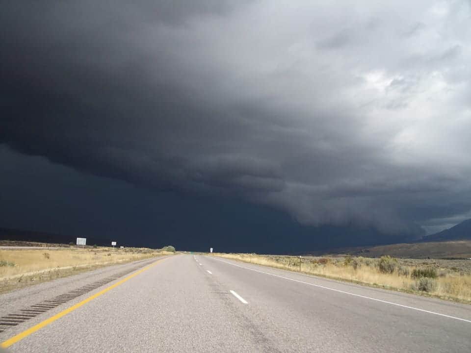
A larger concern is a low pressure system associated with a tropical wave currently on track to impact the Turks and Caicos Islands in the Caribbean. This system is producing gale force winds and has an even chance of becoming a tropical depression or storm by noon on Saturday. Following Saturday, there is a high probability this system will become Tropical Storm Hermine over the weekend.
This system will produce significant impacts as it stays on track to pass through the Bahamas and on through Florida. High winds, heavy rains, life-threatening mudslides, and inland flooding are likely to occur on the Caribbean Islands.
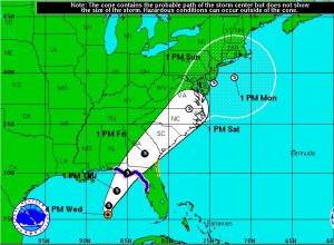
Forecast

Homes inundated by flood waters after record rainfalls between August 11 and 14, 2016.
The low pressure area associated with the tropical wave is currently located in the Caribbean just North of Puerto Rico and Hispanola. Residents and tourists should expect heavy rains and gale force winds that could produce flooding and dangerous mudslides. There is a high degree of confidence that this system will become an organized tropical cyclone on it’s way through the Turks and Caicos before it reaches Florida.
Large, slow moving low pressure systems coming off the warm waters of the Caribbean and the Gulf have the potential to produce torrential rain like that seen in Louisiana earlier this month where some areas saw more than thirty inches of rain in just 48 hours.
Prepare now as this system is very likely to impact Florida and nearby states. Although the wind damage and storm surge are less likely to have the same impacts as a hurricane, a tropical system can still produce significant impacts of Wind, Heavy Rainfall, and Inland Flooding.
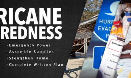
Prepare

Small Portable Generators such as this IQ2000 Inverter from Generac can make life easier during a power outage
Listen to weather radio and local forecasts and be aware that low-lying areas are the first to experience flooding. Review your emergency plan and prepare to put it into action. Stay alert for evacuation notices in the event of major flooding.
Top off vehicles now and keep the fuel tanks full. Fill approved storage containers with gasoline for portable generators. If the power goes out, local stations may not have backup power to keep businesses open. Rotate older fuel into vehicles to use quickly and fill the containers with fresh fuel and add fuel stabilizer.
Start portables and let them run for five minutes to warm up and make starting easier if their use is required. Stock up on maintenance supplies like fuel and air filters, oil, and spark plugs. After five to seven days of continuous operation, portable generators require maintenance.
If you lose power, give power from portables priority to sump pumps, air conditioning, and refrigerators and freezers. Small portables produce limited amounts of power and cannot provide power to every circuit in the house. A manual transfer switch can supply power to hard-wired appliances such as central air conditioners and furnaces. Window air conditioners use far less power and judicious use can help keep a home bearable.
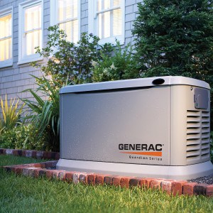
A home standby generator keeps the lights on and the home safe during an outage.
Never back-feed appliance outlets with power from a generator. This practice is both dangerous and often illegal.
Owners of standby generators don’t have these concerns. These units provide backup power automatically and run on municipal natural gas supplies or the property owner’s LP tank. When the utility power is interrupted, they start and run automatically. An Automatic Transfer Switch isolates the house from the local grid and connects it to the generator within seconds of detecting the outage.
Maintenance is required however and homeowners should follow the manufacturers guidelines found in the owners manual for maintenance during an extended outage to ensure their standby generator continues to operate for as long as necessary.
Seasonal Forecast
The Atlantic Hurricane Season has not quite reached the halfway mark. The likelihood of a tropical storm or hurricane increases during the next two months. Gaston is the seventh named storm of the season and the tropical wave and associated low pressure system will become the eighth if it organizes sufficiently to become Tropical Storm Hermine.
Prepare now. Form a plan if you have not already done so and be ready to put that plan into action.


