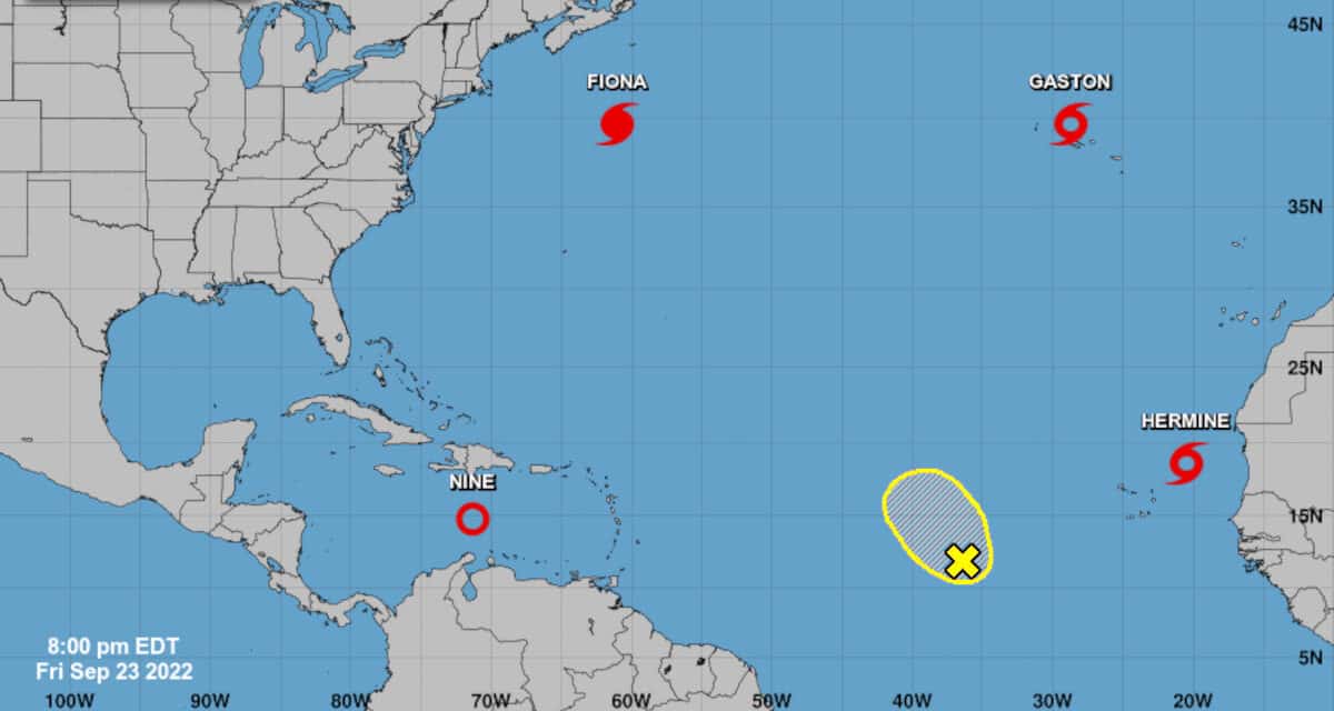
The Five Day Outlook from the National Hurricane Center with 4 active cyclones and a fifth possibility. The monsoon trough (not seen) has numerous areas of convection with potential to form new storms. NHC Graphic
Atlantic Basin Active with 4 Cyclones and 1 Area of Potential Development
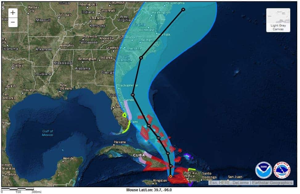
To look at the National Hurricane Center Outlook for September 23, one could easily confuse the map for early September 2020, the year with a record-breaking 31 tropical cyclones. Of particular interest to the United States and the Caribbean is Depression Nine, currently 400-500 miles east-southeast of Jamaica. Nine will cross Cuba as a hurricane and intensify to a major hurricane before it reaches Florida. Residents should begin preparation and follow advice from local authorities.
Atlantic Canada Braces for Fiona
Category 4 Major Hurricane Fiona is on track to landfall in Atlantic Canada as either a hurricane or powerful extratropical cyclone with hurricane-force winds up to 105 MPH. Hurricane Warnings and Tropical Storm Warnings are in effect for Nova Scotia and Newfoundland. Fiona is a large storm with hurricane force wind up to 200 miles across, and tropical storm force winds up to 600 miles across.
Residents and interests in Nova Scotia and Newfoundland should complete final preparations with haste. Deteriorating weather this evening with Tropical Storm and hurricane-force winds overnight and tomorrow.

5PM AST Sep 23 Key Messages for Hurricane #Fiona: High winds, storm surge, and heavy rains expected in portions of Atlantic Canada tonight and on Saturday. Life-threatening surf and rip current conditions expected along the Atlantic coastlines. https://t.co/tW4KeGe9uJ pic.twitter.com/FJovxJlknO
— National Hurricane Center (@NHC_Atlantic) September 23, 2022
Tropical Storm Gaston Hitting the Azores
Tropical Storm Gaston is moving west after arriving between the Western and Central Azores, with 60 MPH sustained winds and gusts up to 70 MPH. Expect Tropical Storm Conditions over portions of the Western and Central Azores. Gaston will produce heavy rainfall through Friday and into Saturday, resulting in flooding and the possibility of landslides.
Residents and interests in the Azores should follow local official guidance.

Here are the 9/23 9 PM GMT Key Messages for Tropical Storm #Gaston. Tropical storm conditions and heavy rainfall expected over portions of the western and central Azores tonight. More: https://t.co/tW4KeGe9uJ pic.twitter.com/vbqJrkzBbK
— National Hurricane Center (@NHC_Atlantic) September 23, 2022
Tropical Storm Hermine near the Cabo Verde Islands
Tropical Storm Hermine formed out of Depression 10, the result of a tropical wave that came off the coast of Africa. Hermine has 40 MPH sustained winds. Located northeast of the Islands, Hermine is moving north northwest. It could hold together for another day before it runs into dry air and very strong southwesterly windshear.
Hermine could bring heavy rain to the Canary Islands through this weekend with isolated totals up to 6 inches. Flash flooding may occur in higher elevations.

#Hermine has formed in the far eastern Atlantic - the farthest east (20.5°W) that a named storm has formed in the tropical (<=23.5°N) Atlantic since Helene in 2018. pic.twitter.com/uRfzASZUkI
— Philip Klotzbach (@philklotzbach) September 23, 2022
Tropical Depression Nine
Forecasters expect heavy rain in the higher terrain of Aruba, Bonaire, and Curacao from Depression Nine currently located 400 miles east-southeast of Jamaica. The rain will spread to other parts of the Caribbean as the depression moves west.
Depression Nine is a cyclone for the Caribbean to watch over the weekend, including Jamaica, the Cayman Islands, and Cuba. Nine will intensify over the next few days. A Tropical Storm Watch is in effect for Jamaica and a Hurricane Watch for the Cayman Islands. Expect additional watches and warnings as the storm progresses and grows stronger. Forecasters expect it to be a hurricane before it reaches The Caymans and then across Cuba into the Straits of Florida. Forecaster expect rapid intensification to a Major Hurricane before it hits Florida, probably on the west coast of the peninsula.
However, computer models show variance in the last two days of the current forecast, and it could hit anywhere along the panhandle or skirt the east coast. The most likely scenario is a landfall somewhere just south of Tampa Bay.
Here are the 11 AM EDT Sep 23 Key Messages for Tropical Depression Nine. Strengthening is forecast in the coming days, and residents in Cuba and Florida should ensure they have their hurricane plan in place.
— National Hurricane Center (@NHC_Atlantic) September 23, 2022
For the latest updates: https://t.co/tW4KeGdBFb pic.twitter.com/ofzDMSNpA5
Low Pressure System West of Cabo Verdes Islands
The tropical low-pressure system several hundred miles west of the Cabo Verdes Islands remains disorganized with a low chance of development over the next 5 days because of unfavorable upper level winds. However, it could slowly develop as it drifts over the central tropical Atlantic. This system has a 30 percent chance of development over the next five days.
Monsoon Trough
The monsoon trough brings tropical waves across Africa which then emerge off the coast with the potential to form into tropical cyclones. Typically, a depression forms first, then a tropical storm. Further development into a hurricane or major hurricane is then possible as it moves over the warmer water of the tropical Atlantic.
Currently, the monsoon trough has many moderate to strong areas of convection within 270 miles south of the trough and within 180 miles north of the trough. These areas of convection will reach the western coast of Africa over the next week and bring the possibility of more tropical cyclones if conditions remain favorable for development.


