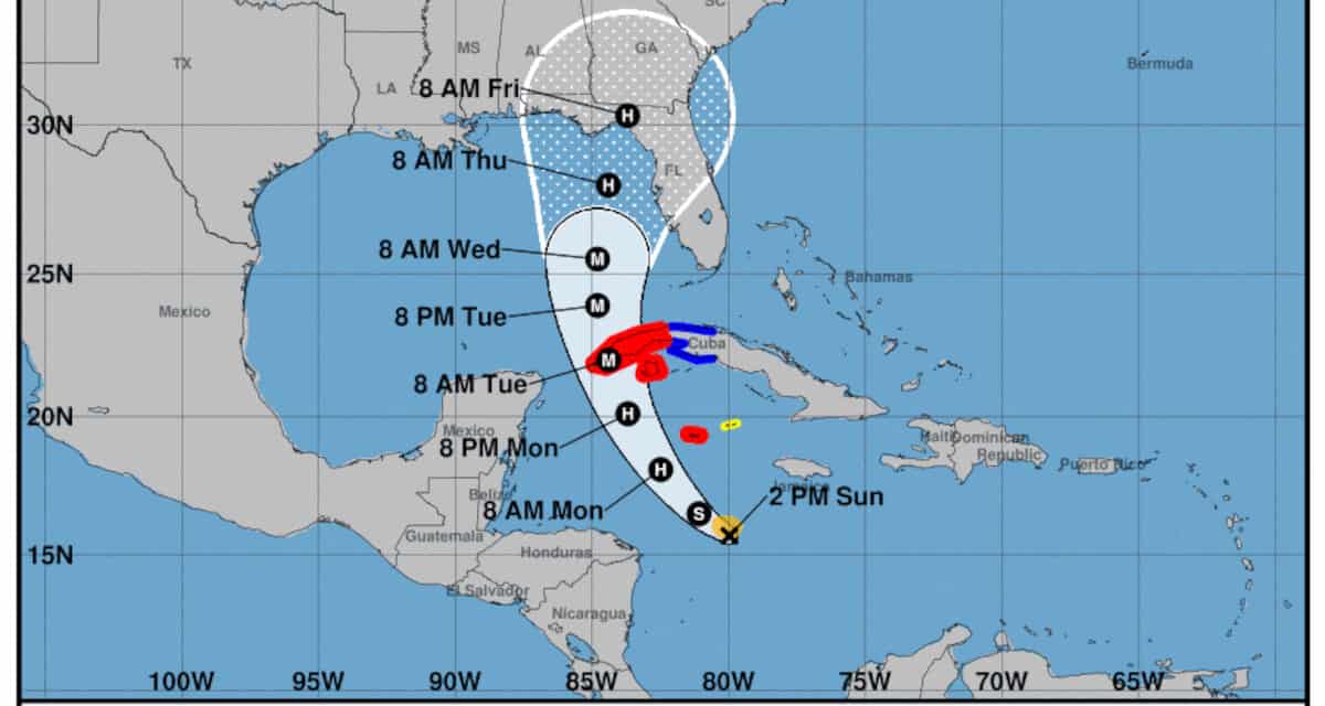
The forecasted strengthening and movement of Tropical Storm Ian as it crosses the western Caribbean, Cuba, and into the Gulf of Mexico. Ian will become a dangerous category 3 or 4 hurricane once in the Gulf. NOAA NHC Graphic September 25, 2022.
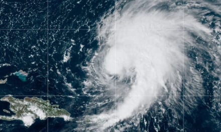
Hurricane Ian Makes Category 4 Landfall
Update: September 28, 2022 Hurricane Ian made landfall near Charlotte Harbor, Florida this afternoon with 155 MPH sustained winds, just 1 MPH short of Category 5. As of 7:00 PM, more than 1.5 million utility customers were without power.
In terms of wind speed, Hurricane Ian is the fifth strongest hurricane to make landfall on the United States. According to reports on Social Media from CBS News and others, the water was drained from portions of Tampa Bay, Sarasota Bay, Charlotte Harbor, and others.
Rare video where water being drained or sucked because of #Hurricane at #Florida's Tampa Bay.#TampaBay#HurricanIan #IanHurricane#Ian
— Sitam Moharana(ANI) (@SitamMoharana) September 28, 2022
(VC-@LarissaScott ) pic.twitter.com/Pl57XiRz6E
#HurricaneIan has officially made landfall, however, many impacts remain a threat:
— NWS Tampa Bay (@NWSTampaBay) September 28, 2022
☔️Up to 2 feet of rain resulting in historic flooding
🌬️ Hurricane/TS force winds
🌊 Life-threatening storm surge
**CATASTROPHIC flooding is anticipated**
SHELTER-IN PLACE!! #FLwx pic.twitter.com/9NY8hLRBNS
- Do not go outside until the storm passes.
- Do not wade or swim in flood waters.
- Follow all generator safety guidelines.
Second Landfall Expected on Friday
Hurricane Warnings remain in effect for portionas of the Florida East Coast and West Coast. Tropical Storm Warnings remain in effect for southern Florida, the Big Bend, north along the East Coast from the Palm Coast to the Georgia border, then north to the South Carolina border to North of Wilmington North Carolina. A tropical storm watch is in effect from Wilmington, North Carolina to Cape Hatteras.
Ian will emerge over the Atlantic near Port Orange / Daytona Beach as a strong tropical storm. Forecasters have not ruled out further intensification to hurricane strength before making a second landfall between Savanna, Georgia and Charlston South Carolina. Storm surge warnings in effect for the Florida, Georgia, and South Carolina Coastlines.
— End Update —
Thursday/Friday Landfall—Significant Impacts Across Florida Panhandle and Peninsula
The NHC predicts Ian will strengthen to a major hurricane as it crosses the westernmost tip of Cuba. The storm will continue to curve north and north-northeast as it strengthens—possibly to category 4—a very powerful and dangerous hurricane. On the 3-5 day forecast, computer models vary widely to the east and west of the NHC forecast for a landfall on the Big Bend Coast. The current track is further north and a little west than originally expected.
Florida Governor Ron DeSantis Declares State of Emergency—Landfall of Hurricane Ian Constitutes a Major Disaster. (Amended Executive Order 22-219) The Emergency Order now includes the entire state of Florida.
All Florida residents, businesses, and other interests should monitor this storm as it develops. Begin hurricane preparations now. The NHC expects significant impacts across the Florida Peninsula and Panhandle including storm surge and flooding, extreme winds, tornadoes, and widespread power outages.
The Governor and the Florida Division of Emergency Management urge everyone in the path of the storm to prepare.
Top 10 Tips to Survive a Hurricane Disaster
Tropical Storm Ian formed out of a tropical wave over the Western Caribbean Sea. This system emerged off the coast of Africa and crossed the tropical Atlantic to the Windward Islands. Forecasters gave the tropical wave a 90 percent chance of development. Tropical Depression Nine organized on the morning of Friday, September 23 and strengthened to a Tropical Storm by 11:00 PM EDT Friday Evening.
Watches issued by the NHC included a tropical storm watch for Jamaica and a hurricane watch for the Cayman Islands. Ian stayed away from Jamaica and the authorities cancelled the watch there.
Grand Cayman Island and the western third of Cuba is under a hurricane warning and tropical storm warning. Hurricane Warnings are now in effect for the Cayman Islands.
As the storm grows in size and approaches Cuba on Tuesday, the first watches and warnings could go into effect for the Florida Keys with additional watches and warnings issued as the storm progresses into the Gulf and nears Florida.
Here are the 11am EDT Sunday 25 Sep Key Messages for Tropical Storm #Ian.
— National Hurricane Center (@NHC_Atlantic) September 25, 2022
A Hurricane Warning is now in effect for portions of western Cuba.
Latest Advisory: https://t.co/tnOTyfOjMY pic.twitter.com/kQVDbE5768
#Ian is forecast to become a Category 4 #hurricane with maximum sustained winds of 140 mph in the Gulf of Mexico on Wednesday. If that forecast were to verify, Ian would be the strongest September hurricane in the Gulf of Mexico since Rita (2005). pic.twitter.com/GMU7gnHAKD
— Philip Klotzbach (@philklotzbach) September 25, 2022
Hurricane Ian Emergency Preparedness

Any impacts on the Florida Keys could occur well in advance of impacts to the Florida Peninsula and Panhandle. These impacts could be significant if the storm follows a more easterly track than currently forecast. Expect Storm Surge, heavy rain, and flooding.
How to Use a Portable Generator for Emergency Power
Must Have Items:
- Non-perishable food for 5 days
- 5 Gallons of water per person (= a 5-day supply)
- Prescription Medicines for at least 5 days. Talk to your pharmacist/doctor for emergency prescription medicine supplies.
- If you have medication that must be refrigerated, make sure you have a way to keep it cold.
- Food and Water for Pets
- A reasonable amount of cash on hand in smaller bills: ones, fives, and tens, with a few larger bills kept separately.
- Supplies to shelter in place including a large tarp, blankets, sleeping bags, etc.
- Personal hygiene items
- Keep vehicles fueled and ready to go.
- Radio, flashlights, extra batteries.
- Emergency Power Source
In-Stock Portable Generators Ready to Ship
Must Do Items:
- Know your evacuation route.
- Be prepared to take your supplies and evacuate if ordered.
- Prepare your home. Move all loose objects indoors.
- Lawn and patio furniture
- BBQ grills
- Toys
- Lawn tools and equipment
- Remove any dead branches. Trim trees back from the house.
Portable Generator Safety Rules to Live By
- Cover Windows and doors, especially garage doors and sliding patio doors. Storm shutters and hurricane rated doors are best, but if you don’t have them, use 3/4-inch plywood with 5/8-inch lag screws screwed into the house framing every six to 10 inches.
- Inform family members of your plans and where you will go if you evacuation. Designate one family member as your point of contact and keep them up to date.
- Include your pets in evacuation plans. They are completely reliant on you for their safety.
- If you intend to evacuate, complete preparations on your home and leave as early as possible. Make hotel reservations well in advance and arrive before the earliest check-in time if possible.
- Start and warm up your generator. Check fuel supplies and top off as required.
- Keep your phone batteries charged and have a way to charge them during an outage.
Hurricane Preparedness
- Hurricane Hazards and Risk Factors
- Make a Hurricane Evacuation Plan
- Hurricane Preparedness Kits and Supplies
- Hurricane Insurance Checkup and Updates
- Prepare Your Home for Hurricanes
- Help Neighbors with Hurricane Preparedness
- Complete Your Hurricane Preparedness Plan
- Emergency Preparedness Tips
- How to Prepare for a Power Outage
- 10 Tips to Survive a Hurricane Disaster
- FEMA Recommends a Generator
- Hurricane Disaster Preparedness
Tropical Storm Ian is expected to strengthen into a hurricane and approach the Florida Gulf Coast mid-week.
— Ron DeSantis (@GovRonDeSantis) September 24, 2022
Floridians should take precautions.
Follow @FLSERT for updates about the storm. pic.twitter.com/Iqdn6wCXbJ
This morning the State Emergency Operations Center is activated to a Level 1 to respond to Tropical Storm #Ian. During this full-scale activation, @FLSERT is fully staffed by Division personnel and all Emergency Support Functions. pic.twitter.com/3PznVMbhJt
— FL Division of Emergency Management (@FLSERT) September 25, 2022


