
Tropical Storm Dorian Expected to Become a Hurricane by Tuesday Morning
Update: August 27, 10:00PM EDT: A Hurricane Watch for Puerto Rico is in effect. Tropical Storm Warnings were issued for Puerto Rico and Hispaniola. The National Hurricane Center’s latest key messages regarding Tropical Storm Dora include advice for residents of Florida and the Bahamas to monitor the storm and ensure their hurricane plan is in place. The possibility of hurricane or tropical storm conditions including storm surge along the Florida East Coast and in the Bahamas has increased.
Puerto Rico and the U.S. Virgin Islands can expect Tropical Storm Conditions on Wednesday, then Wednesday night and Thursday in the Dominican Republic and Puerto Rico. Hurricane Conditions are possible in Puerto Rico and the Dominican Republic.
Uncertainty of Dorian’s strength later this week and into the weekend remains higher than usual because interaction land may weaken the storm or cause it to lose organization. Impacts later this week will include heavy rainfall and the potential for flash floods and power outages.
If Dorian survives the interaction with Puerto Rico and Dominican Republic, the 72 to 120 hour forecast includes hurricane or near hurricane force winds as the storm passes through the Bahamas and approaches the Florida East Coast.
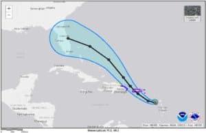
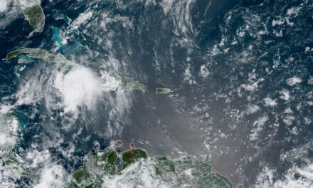
August 26th, 2019: Tropical Storm Dorian continues to strengthen as it pushes into the Caribbean. The National Hurricane Center has issued Hurricane Watches and Storm Warnings for portions of the Lesser Antilles. According to the current forecast at the time of this post, Dorian will reach Puerto Rico and Hispaniola as a Category 1 hurricane with sustained winds of 80 MPH and gusts to 100 MPH.
Interaction with land over the Hispaniola could weaken Dorian to a Tropical Storm as it heads for the Bahamas, but it could strengthen again before reaching Florida. The forecast on August 26th indicates a possible landfall anywhere along the East Atlantic Coast or the Gulf Coast if the storm continues the present course.
Dorian is moving North-Northwest at 14 MPH with sustained winds of 60 MPH and a minimum pressure of 1002 mb. It will affect the Lesser Antilles island group through Tuesday morning, then Puerto Rico and Hispaniola from Wednesday night into Thursday morning. It could start affecting the Florida Coast late Saturday.
St. Lucia is under a hurricane warning. The NHC also issued Tropical Storm warnings for Barbados, St. Vincent, and the Grenadines.
Accuweather reports that Dorian’s path could take it between Puerto Rico and the Hispaniola. Staying over water allows Dorian to maintain its strength rather than weaken. Less interaction with mountainous terrain increases the chance of U.S. landfall as a strong tropical storm or hurricane.
National Hurricane Center Key Messages
August 26th, 2019
- Expect Tropical Storm conditions in the Lesser Antilles Islands tonight and Tuesday. Hurricane Conditions are also possible. The NHC has issued a Hurricane Watch for St. Lucia. Heed advice from local officials and meteorologists.
- 3 to 8 inches of rain with locally heavier totals up to 10 inches from Martinique to St. Vincent and the northern Windward Islands.
- The NHC expects to issue Tropical Storm and/or hurricane watches for Puerto Rico and Hispaniola later today.
- Potential impacts on the Bahamas and the United States remain uncertain. Interaction with land will weaken the storm. Crossing warm ocean water will strengthen it.
Advance Preparation
It is never too early to Prepare for a Hurricane or Tropical Storm. U.S. Residents currently have 5-7 days to prepare for the possibility of any impacts. Preparation now means less to forget or set aside as the storm approaches.
- Review your Hurricane Preparedness and Evacuation Plans.
- Check with local official information and news about the storm and any local impacts.
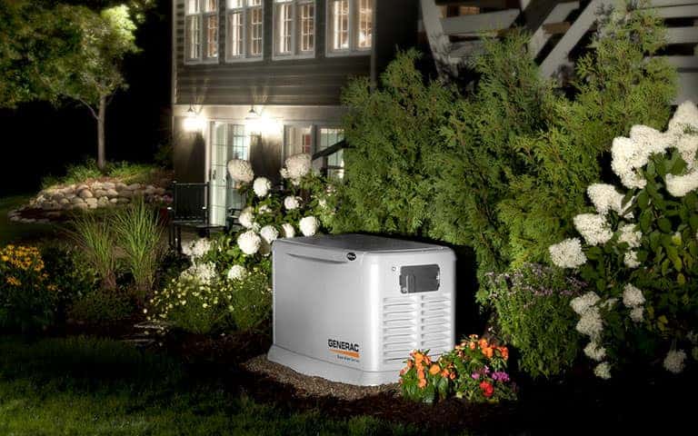
- Perform maintenance on vehicles. Keep the tanks topped off during the week. This is a good time to rotate stored gasoline into vehicles and refill the gas cans for portable generators.
- Complete maintenance on standby generators before the storm arrives. Doing it now may reduce maintenance time during extended outages. Keep several maintenance kits on hand and several additional bottles of oil.
- Start and run portable generators. Review your plan for portable generator use after the storm setup. Plan to protect the portable generator from rain. Review portable generator safety rules.
- Check and restock your five-day supply of nonperishable food and water. Review other supplies including batteries, flashlights, and shelter in place materials. Discuss the possibility of a hurricane with family members and how they can help prepare.


