Will Hurricane Season 2020 Bring Another Year of Destructive Storms?
Forecast Update August 11, 2020
The Tropical Meteorology Department at CSU and the NOAA have issued dramatic forecast changes from an active or very active season to extremely active.
So far the 2020 Atlantic Hurricane Season has broken records from Tropical Storm Arthur to Hurricane Isaias. Cristobal remained organized as a tropical depression all the way to Wisconsin and regained strength as a post-tropical storm over Lake Superior on its way to Hudson Bay, Ontario. Every storm since Cristobal set a record as the earliest numbered storm in history. Dolly the earliest fourth named storm, Edouward the earliest fifth.
As the Colorado State University Tropical Meteorology Department prepared to publish the August 5 update to the season outlook, the earliest ninth storm of the season was on its way to Florida and a landfall in North Carolina.
Factors that contributed to a dramtic forecast change from active to extremely active include a weak El Nino in the Pacific Ocean, warm Atlantic Ocean water, relatively low vertical wind shear, and an active West African monsoon season.
| Named Storms | Hurricanes | Major Hurricanes | Accumulated Cyclone Energy | |
| CSU | 24 | 12 | 5 | 200 |
| NOAA | 19-25 | 7-11 | 3-6 | 129-212 |
Season Forecast Update June 5, 2020.
On June 4, 2020, the Tropical Meteorology Project at Colorado State University updated its April 2, Forecast for the 2020 Hurricane Season. Previous discussions indicated an above average season with up to 16 named storms.
The forecast has increased slightly to 19 named storms (12 average) for a well above average season. This includes 9 hurricanes (6.4 average) and 4 Major Hurricanes (2.7 average.) Accumulated Cyclone Energy of 160 versus the average of 106. Other organizations have updated their forecasts with similar numbers.
The year started early when Tropical Storms Arthur and Bertha formed before the season started on June 1. Arthur came within 20 miles of North Carolina’s Outer Banks. Bertha made landfall a week later in South Carolina. Tropical Storm Cristobal is expected to hit Louisiana this weekend on June 7.
–end update
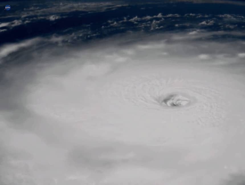
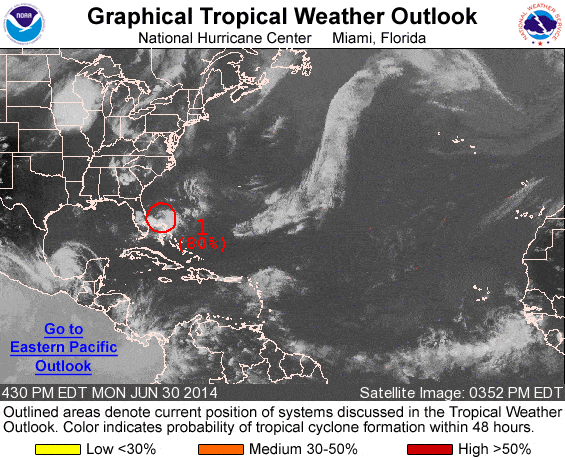
(NOAA Satellite Photo)
After four consecutive years of destructive storms, residents in the Caribbean and along the Gulf Coast and East Coast are ready for a break. Though 2017 was the costliest, 2019 tied earlier records as the fourth most active season with 20 tropical cyclones and 18 named storms. 2019 was the fourth consecutive season to produce Category 5 Hurricanes with Dorian and Lorenzo. Initial long-range forecasts and outlooks pointed at an average to above average season.
Long-range forecasts can’t provide an accurate picture of the upcoming season. As the season approaches, forecast reliability improves. However, no one can predict months in advance of when a hurricane will form and if it will make landfall. Tropical cyclones may form in any month of the year. The most activity takes place during the hurricane season with the greatest risk during the peak months of August, September, and October.
Scientists and meteorologists can only look at current conditions over a relatively short time to forecast weather events over the coming year. In December, The Tropical Meteorology Project of the University of Colorado issues a discussion of the next hurricane season—a period five to 11 months in the future.
Weather forecasts greater than three days often change and may look nothing like the original forecast. The Tropical Meteorology Project releases seasonal forecasts in April, June, July, and August. They also issue biweekly forecasts for accumulated cyclone energy during the season’s peak from August to October.
The Atlantic Hurricane Season 2020 begins on June 1 and ends on November 30.
Hurricane Season 2020 Risks

Tropical Cyclones includes Depressions, Storms, Hurricanes, and Major Hurricanes. Each is stronger and better organized than the previous.
- A Tropical Depression can produce heavy rain and
sustained winds up to 39 MPH with stronger wind gusts. - Tropical Storms produce more rain—often more
than a hurricane—and higher sustained winds up to 73 MPH. Damage from wind is
generally not catastrophic, but the floods from heavy rain cause widespread devastation.
Strong Tropical Storms can bring include life-threatening storm surge. - Hurricane-force winds start at 74 MPH. Higher
winds drive water ahead of the storm to form a mound of water known as storm surge
that comes ashore with the hurricane. In some cases, it may leave shallow ocean
areas empty of water. - Major Hurricanes from Category 3 to Category 5
have sustained winds greater than 111 MPH. Category 5 Hurricanes exceed 156 MPH.
Hurricane Dorian in 2019 had sustained winds that exceeded 185 MPH and gusts
over 200 MPH. The 28-foot storm surge with Hurricane Katrina contributed heavily
to the 1500 lives lost.
Storm Surge and Inland Flooding take more lives and cause more damage than all other risks combined from Tropical Storms, Hurricanes, and Major Hurricanes.
Extreme wind makes headlines and features weather forecasters hunched over against the wind as they give their reports. Beyond the drama of news reporting, high winds can cause considerable damage. Good structural design, adherence to building codes, and well-prepared homes and building prevent most major damage.
Hurricanes and Tropical Storms cause widespread power outages that can last days, sometimes weeks. It took utility crews up to five weeks to restore power to some portions of New Jersey after Hurricane Sandy. Utility customers without power may rely on portable generators until the limited local supply of gasoline runs out. Supplies of food and water are in short supply after a hurricane because delivery trucks lack access. Communities become isolated by the storm damage, flooding, and other factors.
Did you know that a standby generator starts and runs in any weather, including a hurricane? Seconds after the outage hits, the generator starts and signals the automatic transfer switch to turn off the utility lines and supply power to the house from the generator. Electricity for refrigerator and freezer, heating and air conditioning, home medical equipment, and lights and small appliances. They supply power from the moment it goes out until the utility restores service.
Other risks include rip currents before a storm nears land or as it passes unseen and far offshore. Heavy surf conditions attract onlookers and the rip currents drag swimmers away from the beach. Instead of fighting the current, swim perpendicular to it until free and then return to shore. Hurricanes spawn short-lived tornadoes that wreak their own brand of havoc. Cold weather during an outage can freeze pipes which then burst and flood the house.
What Will Hurricane Season 2020 Bring?

The CSU Tropical Meteorology Project December Assessment provides five scenarios for the 2020 Hurricane Season. The assessment relies in part on the Atlantic Multi-Decadal Oscillation (AMO) and the phase of the El Niño Southern Oscillation (ENSO). Using the AMO and ENSO Phase, forecasters predict an Accumulated Cyclone Energy for the Atlantic Basin which translates into an approximate number of tropical cyclones and named storms.
The current ENSO outlook indicates a season without the formation of El Niño and average to above average tropical cyclone activity.
- 30 percent chance of an ACE~ 130 without an El Niño.
More than 12 named storms, at least 6 hurricanes, and 2-3 major hurricanes. - 20 percent chance of an ACE ~80 without an El Niño.
8-11 named storms, 3-5 hurricanes, and 1-2 major hurricanes. - 15 percent chance of an ACE~170 without an El Niño.
14-17 named storms, 9-11 hurricanes, and 4-5 major hurricanes.
Like any weather event, forecasts predicting the ENSO phase so many months in advance lacks precision. If the ENSO phase shifts toward El Niño during the summer and fall, the result could be lower than average activity.
- 25 percent chance of an ACE ~80 with an El Niño.
8-11 named storms, 3-5 hurricanes, and 1-2 major hurricanes. - 10 percent chance of an ACE~50 with an El Niño.
5-7 named storms, 2-3 hurricanes, and 0-1 major hurricanes.
The average from 1966 through 2009 included 11.3 named storms, 6.2 hurricanes, and 2.3 major hurricanes. Without an El Niño, the chance for more storms increases. According Climate.gov, El Niño lowers the risk of tropical cyclones in the Atlantic Basin. Changes in vertical wind shear (speed and direction) between 5,000 and 35,000 feet lower risk and reduce storm intensity.
Overall the December Assessment by the CSU Tropical Meteorology Project indicates a 65 percent chance for an average to above average season, with a 15 percent chance of a very active season. Conversely, it indicates a 35 percent chance for an average to below average season and just a 10 percent chance for a quiet, inactive season.
Prepare in Advance of the 2020 Atlantic Hurricane Season

The June 1 start of the 2020 Hurricane Season is just around the corner. Ready.Gov advises everyone in the United States and its territories to create emergency plans. Despite annual campaigns for hurricane preparedness, disaster planning, and evacuations, most of the population lacks enough supplies to last three days or knows where to go if authorities order an evacuation when a hurricane takes aim on their home and community.
At the first sign of an approaching storm, grocery stores and home centers run out of supplies. Canned food and water, bread, and other staples disappear from shelves. Home centers run out of plywood for boarding up windows and portable generators for emergency power.
Are you ready?


